What Cincinnati’s Brent Spence Bridge can tell Portland

There’s plenty of time to fix the Interstate Bridge Project

Contrary to claims made by OregonDOT and WSDOT officials, the federal government allows considerable flexibility in funding and re-designing, especially shrinking costly and damaging highway widening projects

In Cincinnati, the $3.6 billion Brent Spence Bridge Project

  • Was downsized 40 percent without causing delays due to environmental reviews
  • Got $1.6 billion in Federal grants, with only about $250 million in state funding plus vague promises to pay more
  • Is still actively looking to re-design ramps and approaches to free up 30 acres of downtown land

For years, the managers of the Interstate Bridge Project have been telling local officials that if they so much as changed a single bit of the proposed IBR project, that it would jeopardize funding and produce impossible delays.  Asked whether it’s possible to change the design, and they frown, and gravely intone that “our federal partners” would be displeased, and would not allow even the most minor change.  It’s a calculated conversation stopper—and it’s just not true.

Across the country, in Cincinnati, local leaders–who’ve already gotten a commitment of $1.6 billion in federal funds—based on a modest down payment and vague commitments to pay more.  Collectively, Kentucky and Ohio still have to figure out where about $1.5 billion in state funding will come from.

The new bridge over the Ohio River could be one of these two designs: cable-stayed or tied arch. Ohio and Kentucky officials pictured these options in a July 2022 presentation about the Brent Spence Bridge Corridor Project.

Last year, in response to local government concerns, the two state DOTs reduced the size of the Brent Spence Bridge by 40 percent from the version that the Ohio and Kentucky DOTs pushed through the environmental review process.  And that change isn’t expected to affect its environmental approvals or timetable.

Not only that, but local governments–led by Cincinnati—are still actively pushing for a major re-design of the bridge’s on- and off-ramps to free up 40 acres of land in downtown Cincinnati for urban redevelopment—something that they believe can be done without jeopardizing the project.

This is an object lesson for Oregon and Washington:  The federal government doesn’t require all local funding to be in place before it makes its commitment, it’s possible to shrink a project even after its gotten its environmental approval, and its also possible, even after getting the federal funding, to make major changes to the project design to lessen its impact on urban spaces.

As Metro President David Bragdon observed, Oregon and Washington DOT officials routinely lie about federal requirements and deadlines to block local officials from designing better and more affordable highway projects.

Leadership at ODOT frequently told me things that were not true, bluffed about things they did not know, made all sorts of misleading claims, and routinely broke promises. They continually substituted PR and lobbying gambits in place of sound engineering, planning and financial acumen, treating absolutely everything as merely a challenge of spin rather than matters of dollars or physical reality.  . . . ODOT management has revived one of its favorite old falsehoods by claiming they are facing an “imminent federal deadline,” and that if local leaders don’t knuckle under to ODOT’s plan–and soon–the region will lose millions or tens of millions of dollars forever.  Creating fictional “federal deadlines” and other federal processes as an excuse for false urgency is a familiar ODOT tactic.

For too long, highway officials have gotten away with their best Jerry Lundegaard impressions, telling state and local officials that their hands are tied, because their manager (in another room) just won’t approve a better deal or not charging for the under-coating.  Cincinnati’s Brent Spence project shows the federal government will allow changes that make highway projects have fewer environmental impacts, become more affordable, and benefit local communities.

Honey:  I shrank the bridge

The original design for the Brent Spence Bridge was approved by the US Department of Transportation in a “Finding of No Significant Environmental Impact, (FONSI)” in 2012.  As originally proposed, the bridge would have been nearly 150 feet wide.  Not only was this design over-sized (and expensive) but it had significant impacts on  the City of Covington Kentucky (the southern terminus of the new bridge).  The project languished without funding for more than a decade.

In 2022, the Kentucky and Ohio Departments of Transportation agreed to significantly reduce the width of the project.  They width of the double-decker bridge was reduced from 145.5 feet to 84 feet.

In June, 2022, the new, much more compact design was announced:

Based on engagement and technical analysis, the announced Friday said, the footprint of the new bridge has been significantly reduced from the alternative approved in 2012. . . . . The new bridge was planned to cover nearly 25 acres and span nearly 150 feet in width. Revised plans show the new bridge at almost half the size of the 2012 footprint – covering approximately 14 acres and 84 feet in width. (emphasis added)

This was a major concession to local leaders:

Covington Mayor Joe Meyer, led the negotiation for the City, called the agreement a monumental victory for Covington residents and businesses.  . . . “Meyer said it will “reduce the width of the driving companion bridge by over 40 %. It’s a 61 and a half foot reduction in the driving width of that bridge.They’ve reduced the additional right of way that was necessary by 10 acres, another 40 plus percent reduction in right of way acquisition.”

The Federal Highway Administration is being asked to “re-evaluate” it s NEPA approval.  The Kentucky and Ohio transportation departments are preparing an updated Environmental Assessment, and FHWA is expected to issue a revised “FONSI” this Fall.  The key argument made by the state transportation departments is that the new, smaller design is within the “footprint” of the already approved 2012 design, and therefore can be expected to have fewer environmental impacts.

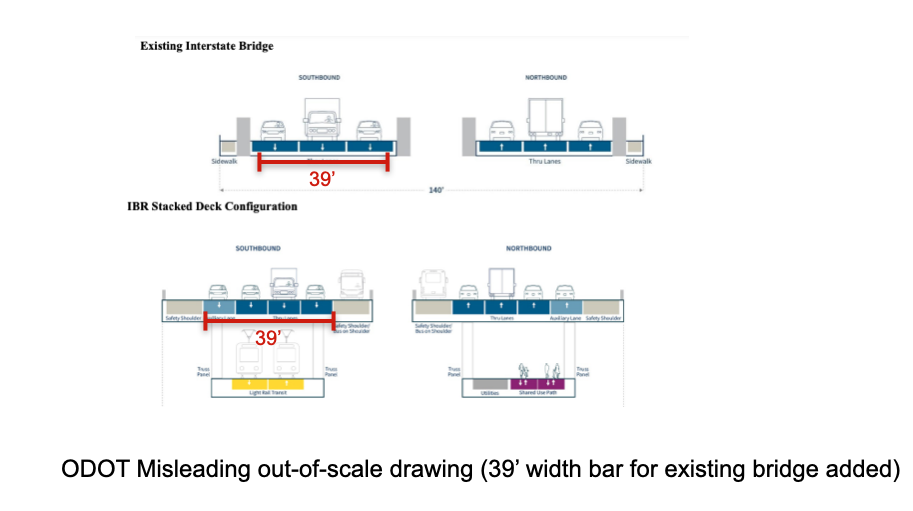
Here’s the lesson for Oregon and Washington:  Just because the decade-old plans for your bridge called for a massively wider freeway, nothing in the federal environmental review process precludes you from making the project smaller.  That won’t slow down the environmental review process, and it’s no obstacle to getting federal funding.  For the proposed Interstate Bridge Replacement project, this means that a right-sized bridge, coupled with retaining (rather than replacing) existing interchanges, would likely get FHWA approval.

The bridge is approved:  Now let’s re-design it

The current design for the Brent Spence Bridge is now 40 percent smaller than it was a year ago—but the re-design is not over.  Like the proposed Interstate Bridge Replacement Project, the Brent Spence “Corridor” project calls for an expensive set of on- and off-ramps to connect to the new bridge.  On the Cincinnati side of the river, this spaghetti of ramps and intersections would foreclose the urban use of more than 30 acres of prime real estate in the city’s downtown.  Rather than repeat the devastating mistakes of past freeway construction–which obliterated most of Cincinnati’s historically Black neighborhoods–local leaders are calling for a re-design of Brent Spence’s ramps and connections to restore urban use.


Keep in mind that President Biden announced the approval of federal funding in January of this year.  Right now, in May, 2023, the Cincinnati City Council is pushing forward with plans to re-design the project as it passes through the city. The current Cincinnati Mayor, Aftab Pureval, and two former Mayors, John Cranley and Mark Mallory—have all spoken out in favor of a fundamental re-design of the Brent Spence Bridge to dramatically shrink its complex of interchanges and off-ramps, and free up more than 30 acres of land that were devastated by freeway construction. They’re calling on the Ohio Department of Transportation, and US DOT Secretary Pete Buttigieg, to give them flexibility to re-design the project—something the city has done successfully with other highways in Cincinnati:

We also applaud Transportation Secretary Pete Buttigieg (whom we have both known for many years) for implementing new rules that reward designs that are urban friendly. The federal government now embraces the kind of progressive vision our city showed in redoing Fort Washington Way and the I-71/MLK interchange.

The progressive design build process that ODOT has rightly put in place requires that local input be an official part of selecting a contractor and finalizing with that contractor a design that meets local goals and ambitions. That process has only just begun and any suggestion that it is “too late” to make design improvements isn’t paying attention to recent changes ushered in by Secretary Buttigieg.

A local group, called Bridge Forward, has come up with a plan to reduce the footprint of the onramps, and trigger urban renovation:

The Bridge Forward Plan

This has a direction implication for the Interstate Bridge Replacement Project in Portland and Vancouver.  In their $7.5 billion project, ODOT and WSDOT are proposing to re-create, and rebuild at great expense, seven closely spaced freeway interchanges, which they—and independent consultants they hired—have said are a fundamental cause of the highway congestion and which are a majority of the cost of the bloated project.

As Cincinnati’s experience shows, even after the bridge has been down-sized, and the federal money committed, there’s still the opportunity to get a more sensible, sensitive design.

The Ohio experience with the Brent Spence Bridge shows that, if local leaders are in agreement, we can shrink the size of the project to reduce its cost, and continue to explore designs that are less disruptive to the urban fabric without slowing down the federal funding, environmental approval, or construction contracting processes.

No money down:  The Feds contributed to the project in return for partial state funding and vague commitments, not hard cash

A key talking point of the Oregon and Washington DOTs is that Oregon has to put $1 billion on the table in order to apply for federal funds.  That’s clearly not the case with the Brent Spence Bridge.  Local television news station WKRC reported that President Biden committed $1.6 billion in federal funds for the project’s total cost, estimated at $3.5 billion.  So far the only state commitments are a $250 million pledge from the Kentucky legislature and an vague statement from Ohio Governor that his state would “pay its share:  That leaves more than $1.5 billion that the two states expected have yet to come up with, as WKRC reported:

That leaves another $1.5 billion in costs to be split between Ohio and Kentucky. The Kentucky General Assembly last year pledged $250 million toward the project, with Ohio Gov. Mike DeWine also promising his state would pay its share.
Ohio and Kentucky have gotten the federal government to commit its $1.6 billion from the bipartisan infrastructure law well before nailing down the local revenues for the project.  The lesson for Oregon and Washington is that they should instruct their state transportation departments to proceed to get the federal funding in place, without insisting on a full up-front payment from the states.  Knowing exactly how much the federal government will contribute will tell the states how big a hole they have to fill, rather than signing them up to pay whatever the project ends up costing.
Editor’s Note:  This commentary has been revised to correct errors in the summary (May 10).


Why can’t ODOT tell the truth?

The Oregon Department of Transportation (ODOT) can’t tell the truth about the width of proposed $7.5 billion Interstate Bridge Replacement Project

ODOT is more than doubling the width of the bridge from its existing 77 feet to 164 feet.

The agency can’t even admit these simple facts, and instead produces intentionally misleading and out of scale drawings to make their proposed bridge look smaller.

If engineers can’t answer a simple question about how wide a structure they’ll build, why should anyone have any confidence in their ability to accurately estimate costs or revenues?  

Why is the width of this bridge, and its actual appearance a state secret?

It’s a simple question, really:  How wide is the $7.5 billion”Interstate Bridge Replacement” that Oregon DOT is trying to sell the Oregon Legislature?  Several members of the Joint Transportation Committee put that very question to ODOT leaders, and simply got a gibberish non-answer.

Oregon DOT’s lobbyist, Lindsay Baker wrote a rambling response to the question, which alternately, offered a long digression on the history of the existing bridges, answered a question the legislators didn’t ask (combined the over-water space covered by the bridges, including the space between the bridges), and offered absurd and meaningless statistics (28 percent of structure area would be “dedicated” to transit.). Baker’s response even included a couple of diagrams—which as we will see were purposely altered to conceal the actual width of the proposed bridge, and make it look smaller. Instead, the chief ODOT talking point is that they are merely adding “one auxiliary lane” in each direction to the existing bridge footprint.

Nothing in Baker’s non-response reveals the actual measurements of either the existing or proposed structures.  Let’s cut to the chase, because these are, ODOT obfuscation notwithstanding, simple facts (the kind the real engineers actually excel at).  The existing bridges have a combined roadway about 77 feet wide.  The proposed bridges would have a roadway that is 164 feet wide. ODOT proposes to more than double the width of the roadway across the river.  The existing bridges carry six lanes of traffic (three lanes in each direction).  The proposed structure is easily wide enough to carry twelve lanes—six in each direction.

Old Bridge:  77 Feet Wide; New Bridge 164 Feet Wide

How do we know this?  It takes a combination a two-second Internet search (the existing bridge) and a public records request and some algebra (the proposed bridge). First, for the record, the existing bridges have roadway widths of 38 feet and 39 feet respectively., for a total roadway width of 77 feet. 

It’s harder—much harder—to find the width of the structure ODOT is proposing.  In describing the width of the “locally preferred alternative” at the time it was approved by local governments, ODOT declined to say how wide the actual structure was, instead it cryptically reported that the LPA will be 16 feet narrower than the Columbia River Crossing proposed a decade ago. 

So, in order to know the width of the IBR, you have to know the width of the CRC.  And, the width of the CRC is effectively a state secret.  In its environment impact statement of 2011, ODOT erased all the actual measurements showing how wide that bridge would be—it took a public records request to get them to disclose that it would be 180 feet wide.  Here’s an excerpt of the plans we obtained via public records request, showing the CRC had a minimum width of roadway of more than 90 feet on the top decks of each of its two spans (other portions of the bridge are even wider, to accommodate a horizontal curve, as the bridge crosses the river). 

So the answer to the ODOT bridge width riddle is that the LPA is 164 feet wide:  180 feet (the width of the CRC) minus 16 feet equals 164 feet.  For the record, ODOT is planning two side-by-side, double-decker bridges with 82 foot top decks and 48 foot bottom decks.  That creates 164 feet of roadway on the top-deck of the two bridges.  In addition, there’s even more space on the bottom deck of these double decker bridges; the bottom decks are about 47 and a half feet wide, meaning that there’s a total of 95 feet of additional travel capacity on the two bottom decks.  ODOT’s plan is for the highway to be carried on the top decks of the two bridges, and for light rail to be located on the bottom deck of one bridge, and a bike/pedestrian path on the bottom deck of the second bridge.

Intentionally Misleading Images

In her letter Joint Transportation Committee, ODOT lobbyist Lindsay Baker waxed poetic about the width of the existing bridges, and included a couple of extremely misleading and not-to-scale drawings of the existing bridge and their proposed alternatives.  We’ll focus on the double-decker bridge alternative which ODOT has characterized as the official “Locally Preferred Alternative” (LPA).  Keep in mind, the Interstate Bridge Program has spent tens of millions of dollars on engineering; its predecessor spent $200 million on the nearly identical Columbia River Crossing, and when asked to provide a drawing, ODOT offers up some “not-to-scale” cartoons to answer a simple quantitative question.

Here are the illustrations Baker provided.  Above is the existing bridge, below is the proposed bridge


We’ve added one small annotation—a red bar showing the width of the wider of the two current bridges (39 feet).  We’ve copied that 39 foot measuring stick to ODOT’s drawing.  It seems to show that ODOT is squeezing four lanes of traffic into the same space as the current bridges three lanes.  But of course that isn’t true:  ODOT has rendered the two bridge images at different scales.  The first clue is that the cars and trucks in the lower, IBR drawing are much smaller than the cars and trucks in the upper (existing) drawing).  We printed out and measured their diagrams.  The top diagram is drawn at a scale of about 1:250 (about one inch equals 20 feet).  The bottom diagram is diagram is drawn at a scale of about 1:375 (one inch equals about 30 feet).  The scales are chosen explicitly to make the new bridge seem smaller than it really is.

We’ve corrected ODOT’s drawing by re-projecting their image at a comparable scale.  (This makes the trucks and cars roughly the same size in both drawings).  With this correction it’s now apparent that the ODOT plan is to more than double the width of the current roadway, from a combined 77 feet between the two existing bridges, to a total of 164 feet between the two proposed bridges.

More than Doubling the width of the I-5 highway bridges—Enough for a 12 full lanes

We know, that at a minimum, ODOT’s plan is to increase the roadway width across the Columbia River from 77 feet to 164 feet–more than doubling the width of the roadway.  The new bridge is 164 feet wide.  How wide is that exactly:  well, its almost exactly as wide as a football field (160 feet).

A 164 foot wide roadway can easily accommodate 12 travel lanes.  Standard travel lanes are 12 feet wide.  Twelve twelve foot travel lanes would occupy 144 feet of the 164 feet of roadway that ODOT proposes for its bridge structure—leaving 20 feet for shoulders.  It is not uncommon on urban roadways, especially on bridges, to accommodate shoulders in this area:  ODOT’s plan would allow for 4 foot inside (left) shoulders) on each crossing and 8 foot outside (right) shoulders.  For reference, as part of its $1.45 billion  I-5 Rose Quarter project, ODOT is proposing 11 foot travel lanes and shoulders of between 3 and 6.5 feet on a viaduct section of the project near I-84.  There’s nothing illegal, unusual, or substandard about 11 foot lanes and somewhat narrower shoulders on urban roadways:  In fact, the Federal Highway Administration prominently praised ODOT for narrow lanes and narrow shoulders on Portland’s I-84 Interstate Freeway.  Here is a page of the USDOT report, “USE OF NARROW LANES AND NARROW SHOULDERS ON FREEWAYS: A Primer on Experiences, Current Practice, and Implementation Considerations.” FHWA HOP-16-060.  The narrow shoulders on I-84 are also featured on the cover of the document.

IBR:  A Pattern of mIsleading, “not to scale” drawings.

Lying with pictures is nothing new for the IBR project.  As we’ve noted before, despite spending tens of millions of dollars on planning, and more than $1.5 million to build an extremely detailed “digital twin” of the proposed bridge, IBR has never released any renderings showing what the bridge and its mile long approaches will look like to human beings standing on the ground in Vancouver or on Hayden Island.  And the IBR also released similar misleading and not-to-scale drawings that intentionally made the height and navigation clearance of their proposed bridge look smaller than it actually is.

ODOT’s not-to-scale image to make the IBR look smaller than the existing I-5 bridge

Hiding the actual width of the bridge they intend to build is a scene-for-scene remake of false claim made for the preceding project—the failed Columbia River Crossing (CRC). In 2010, in response to objections from the City of Portland and Metro, ODOT and WSDOT announced they were reducing the size of the CRC bridge from 12 lanes to 10 lanes. But in reality, all they did was change the references in the project documents to that number of lanes, while literally erasing from the Final Environmental Impact Statement every single reference to the actual widths of the bridges and other structures they intended to build. A public records request showed the actual plans for the bridges — which were not published — were exactly the same size (180 feet in width) as they were for the 12-lane version of the bridge.

ODOT seems to be congenitally incapable of revealing the actual width of any of the major projects it is proposing.  As we’ve pointed out at City Observatory, it has gone to great lengths to conceal the width of the proposed I-5 Rose Quarter project, which as it crosses under the Broadway and Weidler interchanges in Portland will be 160 feet wide.  While the project’s Environmental Assessment pretended the project was 126 feet wide (again, based on cartoon “not to scale” images), secret ODOT documents confirmed that the agency has always been planning a 160-wide roadway.


Reference

Here’s the full letter from ODOT’s Lindsay Baker to the Oregon Legislature’s Joint Transportation Committee.

https://olis.oregonlegislature.gov/liz/2023R1/Downloads/CommitteeMeetingDocument/271285


The Week Observed, May 26, 2023

What City Observatory did this week

Pricing is a better, cheaper fix for congestion at the I-5 Rose Quarter.  The Oregon Department of Transportation is proposing to squander $1.45 billion to widen about a mile and a half of I-5 in Portland—that’s right about $1 billion per mile.  But a new analysis prepared by ODOT shows that pricing I-5 would do a better job of reducing congestion and improving traffic flow than widening the freeway—and would save more than a billion dollars.

ODOT study: Pricing, instead of widening, would save $1.45 billion and reduce congestion more.

ODOT has steadfastly (and falsely) maintained that pricing is “unforeseeable” and has excluded any analysis of the impact of pricing from the project’s Environmental Assessment (EA).  But an ODOT technical memorandum shows that pricing I-5 would significantly reduce traffic congestion and speed traffic flow, without widening the I-5 roadway.  The analysis also flatly contradicts EA claims that widening the highway won’t induce more traffic and also disproves claims made that the project will improve safety.

Must Read

Time for New York to stop giving away valuable street space for free.  Don Shoup, described as the O.G. of parking policy, has pointed advice for the City of New York.  The problem, Shoup notes, is that the city is awash in cars because it literally gives parking away for free.  Most cars sit parked most of the day, or for days on end, and much of the traffic on city streets is cars searching for the elusive open parking space.  All that could end if the city simply charged those who park on city streets for the privilege.  Shoup has worked out that a fee that would keep about 15 percent of parking spaces open at any time would work wonders for the city’s transportation mess:  less traffic, easier parking for those who pay, and plenty of revenue to improve local streets and subsidize mass transit.  He writes:

Demand-based prices for curb parking resemble urban acupuncture: a simple touch at a critical point — in this case, the curb lane — can benefit the whole city. In another medical metaphor, streets resemble a city’s blood vessels, and overcrowded free curb parking resembles plaque on the vessel walls, leading to a stroke. Market prices for curb parking prevent urban plaque.

In New York, a minority of residents own cars, and they tend to have higher incomes than those who don’t own vehicles.  Giving away parking hurts a majority of NYC residents, especially those of limited means.  As Shoup says, it’s time to turn parked cars from freeloaders into paying guests.

False Equivalence:  Bike- and bus-lanes are not the neighborhood destroyers that freeways were.  Los Angeles Metro’s Chief Innovation Officer Selena Reynolds maintained in a recent interview that failing to get enough local assent for bike lanes or bus priority on urban streets was functionally a repetition of the arrogant destruction of neighborhoods by highway builders in the 1950s and 1960s (and in many places to this very day).  Aaron Gordon of Vice strong disagrees.

While Reynolds frets that we are repeating the arrogant, top down approach of the past; Gordon points out that the public involvement process has been subverted, and really represents the interests of older, wealthier car-owning households, creating obstacles to more just forms of transportation.

While humility is a fine trait for a public official to have, it too often crosses over into policy nihilism, which is precisely the wrong lesson to take from the mistakes from the past. The result of this is well-intentioned, dedicated public officials comparing building bike lanes to urban highways. Not all bike or bus lane projects are perfect at their initial conception, but it is, in fact, possible to know if something is good or bad without hearing everyone’s opinion on it.

As Gordon points out, more than a million people were displaced by urban highway construction; there’s no evidence that anyone was displaced by a bike lane or bus lane.  It wasn’t simply the process that was flawed, it was that highway were infinitely more destructive of the urban fabric.  It’s useful to get public input to improve projects, but that shouldn’t dissuade public officials from acknowledging some modes are inherently more just and accessible than others.

Driving less is possible.  The Frontier Group’s Elizabeth Ridlington has a great data analysis looking at state-level trends in vehicle miles traveled per person.  Transportation models (and much public discourse) seems to assume that daily travel is a fixed, irreducible quantity, but in reality, how far we travel (and by what means) can and does change over time.  Critically, it reflects the way we build our communities and how much we subsidize car travel.

The policy takeaway here is that trends in vehicle miles traveled are not unchanging forces of nature.  They are in fact, amenable to policy changes. Places that encourage more urbanization, and provide more options, tend to have much lower growth in VMT than sprawling, auto-dependent states.

New Knowledge

Missing Middle:  Still MIA.  One of the heartening developments in the housing debate has been increasing support for local and state policies that encourage so-called “Missing Middle” housing:  duplexes, triplexes, four-plexes and other small scale, multi-family housing that fall between the traditional singe-family home and larger apartment buildings.

While there is definite progress on the policy front (Minneapolis, Oregon, Washington, and now California—have greatly liberalized the kinds of housing that can be built in many urban single family zones—the needle doesn’t appear to be moving much in terms of national housing supply.

Nationally, builders have been producing starting between about 2,00 and 4,000 new two- to four-unit structures each quarter since 2010.  These levels of production are well below the average for the previous two decades.

Missing middle housing policies are a promising, and positive step in the right direction, but ultimately, the problem of housing production is one of scale, and so far, the missing middle policies have been too small to have much impact.

Robert Dietz, “Multifamily Missing Middle Flat at Start of 2023,” National Association of Home Builders:  Eye on Housing, May 24, 2023.

H/t to: Luca Gattoni-Celli (@TheGattoniCelli)

In the News

Joe Cortright’s analysis of the ODOT was cited in by the Sisters Nugget:  Issuing debt for major highway expansions could jeopardize re-opening Cascade pass highways each Spring.


The Week Observed, May 19, 2023

What City Observatory did this week

Rose Quarter tolls:  Available, but not foreseeable?  There’s a glaring–and illegal–contradiction in the planning for the Oregon Department of Transportation’s $1.45 billion Rose Quarter project.  While ODOT’s financial plan claims that needed funds for the project will come from tolling I-5, the project’s environmental analysis claims that there’s no need to consider the effect of tolling on traffic or the environment, because tolling isn’t “reasonably foreseeable.”

  • Tolls can’t be both “available” and “not reasonably foreseeable.
  • Tolling would eliminate the need to widen the I-5 freeway.
  • Without tolls, ODOT can’t pay for the $1.45 billion Rose Quarter project.
  • FHWA can’t approve the Rose Quarter project because of these errors and contradictions.

No technical fix for road safety.  It’s tempting—but wrong—to assume that the growing death rate on the nation’s roads can be solved with another dose of technology.  A viral video showing a self-driving car blowing through an occupied crosswalk shows autonomous vehicles can be just as indifferent to humans on foot as human drivers.  And at the same time, university researchers are flogging a phone app as a cure for the supposed problem of “distracted pedestrians.”  There’s no shortage of silly ideas as to how technology could be applied to this problem—we have a few ourselves.  But the point is that technology is a diversion, rather than a solution.

The belief that just one more technological advance will reduce road carnage is wrong, and it illustrates our obsession with gizmos, and the car-blindedness that has relentlessly shifts blame and responsibility to vulnerable road users.

Must Read

Cars are getting older.  Axios reports new data show that the average age of a car or truck in the United States is now 12 and a half years, the longest ever recorded. That matters because climate policies are counting on people replacing their internal combustion engines with electric vehicles.  But as people hold on to fossil fueled vehicles longer, we make slower progress toward reducing greenhouse gases.

The transition from gas to electric cars will take decades.  It’ll likely take until at least 2050 — and possibly longer — before most gas-powered cars are off the road, [S&P Global Mobility researcher Todd] Campau says.

The report also shows that, so far, electric ars are less durable that their internal combustion counterparts.  about x.x % of the EVs sold in the last decade have been scrapped compared with about x.y percent of internal combustion vehicles.  The shorter average lifespan of EVs means it will take longer for EVs to replace internal combustion vehicles.

Time for a national “roads review.”  The Frontier Group’s Tony Dutzik says its time to take a considered national look at our highway transportation system.  We really don’t have a national transportation plan:  what we have is a series of state level plans (mostly to expand highways), coupled to a generous and indiscriminate federal firehose of funding.  When aded up, over the next several decades, does our spending on hundreds of billions on roads take us in the direction of meeting our climate and safety goals?

A similar “roads review” in Wales reached the conclusion that the status quo ante of incrementally expanding the road system was fundamentally out of step with the national interest, both for economic and environmental reasons.

Dutzik argues that the transportation fraternity is incapable of reforming itself (as evidenced by a 2019 report published by the Transportation Research Board) and that what we need is a broad-based “people’s roads review” that integrates the diverse critiques of our current car-centric system from urbanists, public health experts, displaced communities, climate change advocates, and fiscal experts.  As he says:

The climate crisis and the safety crisis on our roads – together with the countless other big and small problems driven by our continued emphasis on cars and road-building – demand something bigger than what transportation advocacy has yet been able to deliver. We need a rallying point that knits small movements into a bigger one, that enables the whole to become greater than the sum of the parts, and that provides the public, the media and decision-makers with a common focal point for education, engagement and action.

The Devilish Details of Missing Middle Housing.  Many states are making progress in ending the hegemony of single family zoning, opening up residential zones for duplexes, triplexes and other missing middle housing.  Washington State has recently passed HB 1110, which legalizes multiplex homes and accessory development units in most single family zones.

But as with many things in housing, the complex web of regulations and guidelines that shape what can be built mean that zoning is just one of many obstacles.  Building codes, setbacks, height limits and other provisions can be equally daunting.  Matt Hutchins looks at a new infill development manual from Washington State’s commerce department, which, in theory, is designed as a “how to” guide to promote missing middle housing, but in practice may turn out to squelch real change.

The publication is replete with gauzy watercolor illustrations of hypothetical missing middle developments.  But if you look more closely at what’s being prescribed, especially in the proposed “overlay standards”, the guide does more to limit missing middle housing than to enable it:

 The underlaying premise of these overlay development standards is to make middle housing as palatable to neighbors as possible (low densities, smaller footprints, bigger setbacks, lower heights) rather than embracing the challenge we face with the housing crisis and climate change. The standards do not match up with the reality of many neighborhoods (funky cul-de-sacs, small narrow and deep lots, parcels with buildings already on them). At its very worst, this toolkit will give slow-growth municipalities cover for downzoning by providing the option to select overlays that are less intense for the majority of their currently residentially zoned land.

The complex and interconnected web of regulations regarding housing all reflect and reinforce the dominance of exclusively single-family neighborhoods.  Dismantling this structure will require considerable effort.

New Knowledge

Remote work, urban location and household formation.  Adam Ozimek and Eric Carlson of the Economic Innovation Group have a new paper looking at how work from home has influenced housing demand.  There are some glib assertions that the ability to work at a distance is leading to decentralization and the demise of cities, but this paper points out that the effects are much more nuanced.

While there has been some population movement to suburbs since the pandemic, a striking fact is that urban housing markets remain very robust–prices for centrally located apartments have surged in most cities.

The study shows that households that work from home tend to spend more on housing (rents or mortgage payments) than households that don’t work from home.  That makes sense:  If you’re working at home, you need more space to serve as your “office”—and likely are spending more on the amenity of your home, reflecting the increased amount of time you spend there.  In addition, if you’re working at home, you’re most likely spending less on commuting, which gives you relatively more income to spend on housing.

This finding—higher housing expenditures by work at home households—holds from 2020, but the size of the effect appears attenuated in 2021 (the additional amount spent on housing by work at home households is smaller.). The author’s also find that work at home was associated with increased household formation—think of adult children moving out of the house, couples splitting up, roommates sharing a space moving to separate housing units, etc.  Even though there was some population movement to suburbs, this increased household formation helped maintain robust housing demand in denser neighborhoods.  As the authors conclude:

In general, exposure to remote work led to increases in housing demand as shown, for example, through gross monthly rental payments and home values. However, this effect was smaller for PUMAs with high population densities and expensive housing markets. Indeed, we find a negative effect of remote work exposure on population growth the most dense and expensive PUMAs, suggesting that working from home led to some level of out-migration from these areas. However, in these dense and expensive PUMAs, the positive effect on the household formation helped offset the population loss. In short, one reason places that lost population nevertheless saw robust housing markets was that they had stronger household formation.

Adam Ozimek, Eric Carlson, Economic Innovation Group, Remote Work and Household Formation, April 11, 2023
https://eig.org/wp-content/uploads/2023/04/Remote-Work-and-Household-Formation.pdf

In the News


The Week Observed, May 12, 2023

What City Observatory did this week

There’s plenty of time to fix the Interstate Bridge Project. Contrary to claims made by OregonDOT and WSDOT officials, the federal government allows considerable flexibility in funding and re-designing, especially shrinking costly and damaging highway widening projects

In Cincinnati, the $3.6 billion Brent Spence Bridge Project

  • Was downsized 40 percent without causing delays due to environmental reviews
  • Got $1.6 billion in Federal grants, without only about $250 in state funding plus vague promises to pay more
  • Is still actively looking to re-design ramps and approaches to free up 30 acres of downtown land

Within the past year, the Ohio and Kentucky transportation departments pared the size of the bridge by almost half, without prolonging the environmental review process or sacrificing federal funds.

For years, the managers of the Interstate Bridge Project have been telling local officials that if they so much as changed a single bit of the proposed IBR project, that it would jeopardize funding and produce impossible delays. Asked whether it’s possible to change the design, and they frown, and gravely intone that “our federal partners” would be displeased, and would not allow even the most minor change. It’s a calculated conversation stopper—and it’s just not true.

Must Read

The Playground City?  The persistence of work-at-home and the surge in office vacancies in downtowns has people worried about the future of cities.  One of the nation’s leading urban economists, Ed Glaeser, penned an op ed in the New York Times with his MIT colleague Carlo Ratti, foreseeing a predicting the emergence of the “playground city.”  They argue that New York’s economy is shifting from office work to entertainment:

New York is undergoing a metamorphosis from a city dedicated to productivity to one built around pleasure. . . The economic future of the city that never sleeps depends on embracing this shift from vocation to recreation and ensuring that New Yorkers with a wide range of talents want to spend their nights downtown, even if they are spending their days on Zoom. We are witnessing the dawn of a new kind of urban area: the Playground City.

Glaeser makes the point that, throughout history, cities like New York have successively re-invented themselves in the face of economic and technological changes.  New York’s economy was once fueled by trade and manufacturing, but in recent decades has been propelled by financial and professional services.  They suggest that the city can, and will, reinvent itself again.

Oddly, the column makes no reference to Glaeser’s own seminal article “The consumer city” published two decades ago.  And the term “playground city”  is an echo of Terry Nichols Clark’s 2003 book “The City as an Entertainment Machine.”  These works—and our own City Advantage (2007)— make the case that people don’t live in cities simply to be close to jobs, but that cities offer compelling advantages as places to live, interact with others, and access a diverse array of goods, services and experiences.  In cities, more different and varied goods, services and people are close at hand, and it’s easier to discover and explore new things.

Cities aren’t merely playgrounds:  they’re places we can grow and lead richer and fuller lives.  That’s why urban centers will persist and flourish, even if office employment never returns to its pre-pandemic peak.

Want better transit?  Stop squandering money widening freeways.  Too often, transportation policy is co-opted by “all of the above” multi-modalism:  we can only improve transit if we have a “balanced” program that includes more money to move cars faster.  The Transit Center pushes back against this bankrupt thinking, calling New York State leaders to cancel two big (and counterproductive) freeway widening projects, and instead spending the money on improving transit.  Under the new federal infrastructure law, states and localities have a choice, and there is a trade-off:  most federal formula funds can be “flexed” from highways to transit, if state and local leaders agree.

These phony “balanced” investments inevitably encourage more car traffic, more sprawling development, and undercut the effectiveness and raise the cost of operating transit.  In the face of a climate and road safety crisis, we have to set priorities.

Must Listen.  San Diego Public Radio (KPBS) has a new program: “Freeway Exit,’ exploring the intimate connection between freeways and the nation’s cities. The program is hosted by KPBS metro reporter Andrew Bowen, “Freeway Exit” relates the forgotten history of San Diego’s urban freeway network, and how freeways divided communities and created inequities that still exist today. The series also shows how freeway culture has contributed to the climate catastrophe we’re now facing, and how reimagining our freeways could be a key part of the solution.  Episode two features some vintage audio from the 1950s that captures the sense of unquestioned progress that enveloped cars and freeway building–before the social and environmental costs of car dominance became evident.

In the News

The Portland Mercury quotes City Observatory’s Joe Cortright, in an article entitled: “Build It and They Will Pay: ODOT’s Plans for Tolling Generate Broad Backlash.”


The Week Observed, May 5, 2023

What City Observatory did this week

Why can’t Oregon DOT tell the truth?  Oregon legislators asked the state transportation department a simple question:  How wide is the proposed $7.5 billion Interstate Bridge Replacement they want to build?  Seems like a simple question for an engineer.  But in testimony submitted to the Legislature, Oregon DOT officials went to great lengths to conceal and misrepresent the true size of the massive freeway bridge they’re planning.  The simple fact is ODOT plans to replace a 77′ wide bridge with one that’s more than twice as wide (164 feet) wider than a football field, and enough for twelve traffic lanes.

Lying with pictures is nothing new for the IBR project.  As we’ve noted before, despite spending tens of millions of dollars on planning, and more than $1.5 million to build an extremely detailed “digital twin” of the proposed bridge, IBR has never released any renderings showing what the bridge and its mile long approaches will look like to human beings standing on the ground in Vancouver or on Hayden Island.  And the IBR also released similar misleading and not-to-scale drawings that intentionally made the height and navigation clearance of their proposed bridge look smaller than it actually is.  And for the earlier version of this same project, the Columbia River Crossing, OregonDOT claimed to reduce with width of the freeway from 12 lanes to 10, but instead simply erased all the width measurements from the project’s Final Enviornmental Impact Statement, while keeping the project plans exactly the same.

Must Read

How freeways kill cities.  Economists have long recognized that highway construction leads to sprawling and decentralized development by making it easier and cheaper to travel further. But that’s not all, as Street MN’s Zak Yudhishthu summarizes the latest economic findings about highways and cities, highways and cars also damaged the urban fabric, making city living less desirable.  They quote Federal Reserve economistsJeffrey Brinkman andJeffrey Lin, as showing showing that freeways also reshaped our cities by creating disamenities for center-city residents.

In other words, freeways do more than just link us together. While previous research assumed that freeways drove suburbanization solely by making suburban life better, Brinkman and Lin find that freeways drove suburban flight by making urban life worse. Freeways can serve as connectors, but they also make it more difficult for center-city residents to access amenities and jobs in their cities, alongside other pollutive reductions in quality of life.

Too often, discussions about the impact of freeways just looks at the direct (and devastating) effects of initial freeway construction.  But this is just the first level of harm:  the flood of traffic carried by freeways, coupled with noise and air pollution, is caustic to livable neighborhoods, and leads to population loss and business closures, as places near freeways become hostile, car-dominated spaces.

Visit your Nearest National Parking Lot!  Streetsblog’s Kea Wilson has a cutting parody of our old school national park posters that highlights how much of our nation’s urban centers has been given over to parking.  Building on an illuminating set of maps of parking lots and structures created by the Parking Reform Network, Civicgraphics has created a series of posters highlighting the glories of abundant parking that dominates so much of the urban core.

As Wilson points out, public subsidies to parking (as much as $300 billion annually) dwarf the $3 billion we spend on national parks; so in reality parking lots are more central to our national identity that Yellowstone or Yosemite. It’s a pointed and painful parody to be sure, and it speaks vastly more truth than the fictionalized pedestrian and greenery heavy renderings that are being peddled by highway departments to greenwash road widening projects.

Lessons from California’s first-time home-buyer credit.  Housing affordability is famously a California malady.  In an effort to blunt the problems that first-time homebuyers face, the California Legislature enacted a “Dream for All” a $288 million loan program to provide down-payment assistance to new homebuyers.  While the impulse is understandable, the policy is questionable.  The first issue has to do with scale:  “for all” is rather grand, and while a quarter of a billion dollars is a lot of money, the program provided loans to fewer than 2,600 California households.  In a state with 40 million residents, those are lottery-winner odds.  Little wonder, the whole program was exhausted days after starting. The second issue has to do with who got the loans.  Sharp-eyed reporters at CalMatters noted that a disproportionate share of the loans went to applicants in the Sacramento area.  Apparently, people who worked in and around state government were much more aware and prepared to apply for the program, according to local loan officers:

. . . news of the program spread by word-of-mouth throughout the capital community in the days before the state officially launched the program on March 27. The regional rumor mill may have been churning especially quickly given how much more plugged-in locals are to matters of state bureaucracy. “Sacramento and the surrounding area’s loan officers and Realtors probably got a jump start,” he said.

A final problem has to do with the economics of supply and demand:  while the down payment loans ease the burden of ownership for the relative handful of lucky households that get one, they likely increase the number of prospective bidders for the limited supply of homes for sale.  While 2,500 more qualified buyers in California might not make much difference, expanding the program would likely create even more upward pressure on home prices, aggravating the affordability problem the program aims to solve.

Building more housing helps hold down rents.  There’s a growing body of academic literature showing how building more housing, including new market rate housing–helps hold down rents and address affordability challenges.  The problem is that academic literature seldom filters down.to the public.  Seattle public radio KUOW has a terrific and non-technical explanation of this literature, featuring an interview with UCLA professor Michael Lens, one of the authors.  They frame the question in common-sense terms:  Does building townhomes help hold down rents?  Part of the answer is that townhomes require less land and less public infrastructure (like street frontage) than single family homes, which lowers construction and development costs.  But the more important issue is that by providing more homes, and thereby increasing supply, townhouses help moderate rents.  The KUOW report concludes:

. . . here’s what the science and research is telling us so far: Housing density does bring down the cost to build housing. And most studies seem to suggest that yes, this pattern is repeating over and over in cities that reform their zoning to allow more housing.

New Knowledge

America the lonely and isolated.  Surgeon General Vivek Murthy has released a new report decrying a growing epidemic of loneliness in the US.  In simplest terms, we spend more time apart from one another now than ever before.  Across a broad array of indicators, we’re spending less time with others in social settings:

The Surgeon General’s report echoes many of the themes highlighted in City Observatory’s 2015 report “Less in Common“–emphasizing the growing isolation and declining social interaction in daily American life.

What’s striking about this report is that it clearly links isolation and growing loneliness to a range of negative health outcomes.  As Surgeon General Murthy writes:

Loneliness is far more than just a bad feeling—it harms both individual and societal health. It is associated with a greater risk of cardiovascular disease, dementia, stroke, depression, anxiety, and premature death. The mortality impact of being socially disconnected is similar to that caused by smoking up to 15 cigarettes a day, and even greater than that associated with obesity and physical inactivity.

To any urbanist, the principle causes of growing isolation will be evident in our landscape.  The sprawling, low density development patterns that define our metropolitan areas put us physically further from one another (living largely in single family houses), and require that we spend an inordinate amount of time alone in automobiles as we travel.  The failure to connect these social trends to our built environment is a major shortcoming of the Surgeon General’s report.  Even though its principal recommendation is to “cultivate a culture of connection,” it doesn’t talk about how the physical environment impedes (or promotes) connections.  You won’t find any mention of sprawl, density, commuting or car-dependence in the report.

Half a century ago, the Surgeon General’s report on the health consequences of tobacco helped trigger a major social and policy shift in the way Americans related to smoking.  We’ve banned smoking on planes and in most indoor public places, and these bans, coupled with economic incentives and changes in social attitudes about smoking have reduced deaths and respiratory disease.  We can only hope that this Surgeon General’s report will lead to similarly helpful changes in our communities, promoting greater social interaction–and expand the scope of that concern to the built environment..


Pedestrian safety: There’s no technical fix

Engineers would have us believe that we’re just one shiny new technology away from making streets safer for people walking

Sooner than many of us thought possible, self-driving cars are in testing on city streets around the country.  While a central promise of autonomous vehicle backers has been that this technological advance would eliminate road carnage, there’ve been good reasons to be skeptical.  A viral video of a driverless Tesla blowing past a pedestrian in a marked crosswalk (where the opposing traffic was already stopped) serves as a social media litmus test for people’s view of traffic safety. 

See? The self-driving Tesla drives just like a human: with flagrant disregard for pedestrians.

Autonomous car advocates seem to think that the video shows the technology is just like humans, with the same cavalier attitude toward people outside vehicles, prioritizing getting there faster over endangering human life—”I mean, the vehicle didn’t actually hit the pedestrian, Am I right?”  Others point out that the self-driving Tesla flagrantly violated state law, with zero consequences:  Nobody is tracking down Elon Musk or a software engineer to hand out a citation (or, but for a few feet, an arrest warrant for manslaughter).

There seems to be little improvement from the first days of “self-driving” technology.  In 2016, we reported on a that a self-driving Uber being tested on the streets of San Francisco that had blown through a red light in front of a pedestrian in a marked cross walk.

To engineers, we’re always just one more technology away from safer streets

Some years back, Google unveiled plans for a novel plan to coat the exterior of self-driving cars with a special adhesive that would cause any pedestrians the vehicles struck to adhere to the car rather than being thrown by the impact.  Whether it would be better to find oneself stuck to the car that struck you, rather than being pushed aside, is far from clear. But pedestrian safety in a world of self-driving cars is clearly an issue that needs to be dealt with.

In that vein, the best engineering minds of the University of Alabama, Birmingham (UAB), are on the case, and have come up with—you guessed it—a smartphone app to “protect” pedestrians.  The idea is that it would detect the presence of nearby cars and signal a warning to a user that they ought to stop looking at their phone, because, you know, the leading cause of injuries and fatalities is pedestrian distraction.  (Or so it seems to car-blinded engineers).

A hat tip to Denver’s Jim Charlier, who observed on twitter:

The idea that an app on your phone can protect you from being hit by a driver is such a profound misreading of the actual problem, it’s hard to know where to even start.

We also have to point out that the UAB app is pretty plainly an infringement on an idea that we at City Observatory put forth seven years ago, the pedestrian shock bracelet.  We proposed it with tongue firmly in cheek, but we know the UAB engineers are, no doubt deadly serious.

Pedestrian Shock Bracelets. Most pedestrians are already instrumented, thanks to cell phones, and a large fraction of pedestrians have fit-bits, apple watches and other wearable, Internet-connected devices. We propose adding a small electroshock device to these wearables, and making it accessible to the telematics in autonomous vehicles. In the event that the autonomous vehicle’s computer detected likelihood of a car-pedestrian collision, it could activate the electroshock device to alert the pedestrian to, say, not step off the curb into the path of an oncoming vehicle.

google car diagrams-01

As long as we’re mulling a technical fix that comports with a car-centric, victim-blaming view of traffic safety, let us remind you of a couple of our other ideas.  (And if you don’t like these concepts, UAB, give us a call, we’ve got plenty more like these!)

Personal airbags. Airbags are now a highly developed and well-understood technology. Most new cars have a suite of frontal impact, side curtain and auxiliary airbags to insulate vehicle passengers from collisions. The next frontier is to deploy this technology on people, with personal airbags. Personal airbags could have their own sensors, inflating automatically when the pedestrian was in imminent danger of being struck by a vehicle.


google car diagrams-02

Rocket Packs. While a sufficiently strong adhesive might keep a struck pedestrian from flying through an intersection and being further injured, perhaps a better solution would be to entirely avoid the collision by lifting the pedestrian out of the way of the collision in the first place. If pedestrians were required to wear small but powerful rocket packs, again connected to self-driving cars via the Internet, in the event of an imminent collision, the rocket pack could fire and boost the pedestrian clear of the oncoming vehicle.


google car diagrams-03

We offer these ideas partly in jest, but mostly to underscore the deep biases we have in thinking about how to adapt our world for new technology.  As we’ve pointed out before, while these inventions are advertised as “pedestrian” safety devices, they’re really only necessary because of the danger posed by cars.  The real purpose of this technology is to free drivers from the need and responsibility to look out for pedestrians, so that they can drive faster and more recklessly.

It has long been the case with private vehicle travel that we’ve demoted walking to a second class form of transportation. The advent of cars led us to literally re-write the laws around the “right of way” in public streets, facilitating car traffic, and discouraging and in some cases criminalizing walking. We’ve widened roads, installed beg buttons, and banned “jaywalking,” to move cars faster, but in the process making the most common and human way of travel more difficult and burdensome, and made cities less functional.

Everywhere we’ve optimized the environment and systems for the functioning of vehicle traffic, we’ve made places less safe and less desirable for humans who are not encapsulated in vehicles. A similar danger exists with this kind of thinking when it comes to autonomous vehicles; a world that works well for them may not be a place that works well for people.

Consider the “Drivewave” proposal from MIT Labs and others to eliminate traffic signals and use computers to regulate the flow of traffic on surface streets. The goal is to allow vehicles to never stop at intersections, but instead travel in packs that create openings in traffic on cross streets that allowed crossing traffic to flow through without delay. Think of two files of a college marching band crossing through one another one a football field.

It’s thoroughly possible to construct a computer simulation of how cars might be regulated to enable this seamless, stop-free version of traffic flow. But this worldview gives little thought to pedestrians—the video illustrating Drivewave doesn’t show any pedestrians, although the project description implies they might have access to a new form of beg button to part traffic flows to enable crossing the street. That might be technically feasible, but as CityLab’s Eric Jaffe pointed out, “it would be a huge mistake for cities to undo all the progress being made on human-scale street design just to accommodate a perfect algorithm of car movement.”

Not all of our problems can be solved with better technology. At some point, we need to make better choices and design better places, even if it means not remaking our environment and our communities to accommodate the more efficient functioning of technology.


Thanks to Matt Cortright for providing the diagrams for our proposed pedestrian protection devices.