After more than three years of public debate, ODOT still won’t tell anyone how wide a freeway they’re planning to build at the Rose Quarter
ODOT’s plans appear to provide for a 160-foot wide roadway, wide enough to accommodate a ten lane freeway, not just two additional “auxiliary” lanes
ODOT is trying to avoid NEPA, by building a wide roadway now, and then re-striping it for more lanes after it is built
The agency has utterly failed to examine the traffic, pollution and safety effects of the ten-lane roadway they’ll actually build.
The proposed $1.45 billion I-5 Rose Quarter Freeway Project is all about building a wider freeway. But there’s one question that’s left unanswered in all of the project’s hundreds of pages of p.r. materials and reports: How wide a roadway are they actually going to build?
As we’ve repeatedly pointed out, OregonDOT has gone to great lengths to say that they are merely adding “two ‘auxiliary’ lanes” to the existing I-5 freeway. But they’ve never released clearly labeled, accurately scaled plans that show the actual width of the roadway they’re proposing. The current roadway has two “through” lanes in each direction as it crosses under NE Weidler Street. ODOT claims that they’re just adding two more “auxiliary lanes.” but in reality, they’re building a roadway that could accommodate 10 travel lanes (in addition to lengthy on- and off-ramps for freeway traffic.
That matters, because its a few hours work with a highway paint machine to re-stripe a roadway to get an added lane or two. And because ODOT’s traffic modeling and environmental analyses are based on the assumption that there will only be two additional lanes, the Supplemental Environmental Assessment doesn’t reveal the true traffic, livability or environmental effects of a likely ten lane roadway. (ODOT is looking to exploit a loophole in FHWA environmental regulations—which themselves likely violate NEPA—that allow a road to be re-striped without triggering a further environmental assessment).
At City Observatory, we’ve been following plans by the Oregon Department of Transportation to spend upwards of $1.45 billion widening this mile and a half long stretch of Interstate 5 opposite downtown Portland in the city’s Rose Quarter. As we’ve noted, the agency has gone to great pains to deny that it’s actually widening the freeway at all, engaging in a tortured, misleading and at times absurdist effort.
For more than three years, we’ve e challenged ODOT to reveal the actual width of the project they were proposing to build. The agency’s 2019 Environmental Assessment (which, by law, is supposed to be a full disclosure of the project’s impacts on the surrounding area) contained just a single crude illustration of a cross-section of the project’s right-of-way. Using that diagram, we deduced that the freeway was to planned to be at least 126 feet wide–enough, not just for adding a mere two lanes to I-5 existing four, but actually wide enough for eight full travel lanes plus standard urban shoulders.
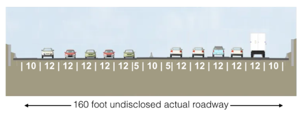
But that actually understates the true size of the project. City Observatory later obtained unreleased documents prepared by ODOT and its contractors showing that the agency planned to build a 160 foot wide roadway through the Rose Quarter–easily enough for ten highway lanes. (We’ve provided a blow-by-blow description of our efforts to pry these secrets from recalcitrant ODOT staff, and copies of the documents we obtained, below).
Still Hiding Freeway Width
In late November, ODOT released its Supplemental Environmental Analysis (SEA) for the Rose Quarter. It continues ODOT’s strategy of deception and obfuscation about the width of the roadway they are planning to build. Just as in the 2019 Environmental Assessment, they’ve published a “not-to-scale” drawing of a cross section of the freeway that entirely omits key measurements (while selectively labeling just a few features).
This illustration is plainly deceptive. The drawing is not to scale, by its own admission. It appears that there are only 3 northbound and 3 southbound travel lanes (the two central parts of the covered section). But the actual width of these portions of the project are never disclosed. By the project’s own admission, each of these spans may be 80 feet (or more), which is easily enough room for five traffic lanes in each direction, with ample provision for shoulders (five travel lanes would occupy only 60 feet of an 80 foot wide covered area). According the the Supplemental Environmental Assessment, the northernmost third of the freeway cover has spans in excess of 80 feet in length (Figure 2.7, page 19).
Massively wide: 160 to 200 feet of roadway
So how wide is the freeway, really? ODOT isn’t saying directly, but we can get a good idea by looking at another poorly labeled (but scaled) drawing included in the project’s right of way report. The diagram (Figure 4 on page 12) shows the existing streets (the grid running North-South and East-West) and the proposed widened I-5 freeway, running diagonally through the Rose Quarter from Northwest to Southeast. The individual lanes of the freeway are indicated. This diagram makes it hard to see or measure, so we’ve zoomed in and added a scale (from the original drawing).
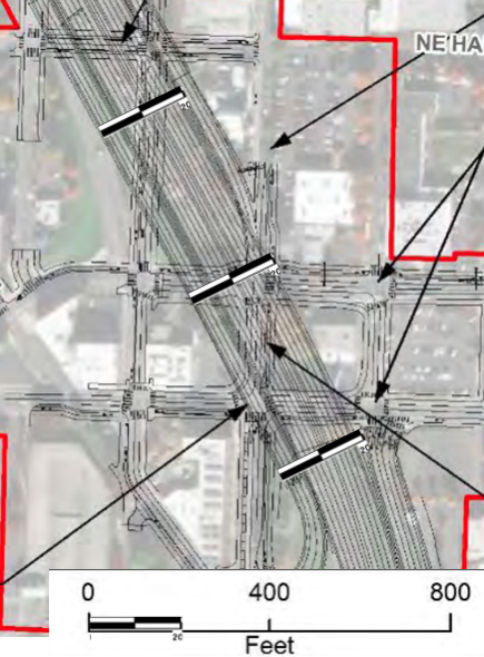
This section shows the portion of the freeway as it crosses under the NE Weidler Street Overpass. Here the freeway is divided into three parts, from West to East a two lane southbound off-ramp from I-5, an eight lane main-line section of freeway, and a two lane North bound off ramp. Including all the lengthy ramps, the footprint of this freeway is 12 lanes wide.
Again, these lane markings aren’t definitive. Let’s look at the actual width of the roadway. We’ve added a 200 foot scale at three points along the freeway. It’s evident that the freeway is more than 200 feet wide near North Hancock Street (the northernmost scale. It is nearly 200 feet wide at NE Broadway (the middle scale), and slightly less than 200 feet wide just south of NE Weidler (the southernmost scale). This width is more than enough to accommodate ten travel lanes, as well as the freeway’s proposed on and off ramps
Violating the National Environmental Policy Act
The purpose of an environmental assessment is to disclose the likely effects of a proposed action, in this case, how a wider freeway will affect the community and the environment. By concealing the actual physical width of the structure they intend to build, the Oregon Department of Transportation is making it impossible for the public to accurately understand the effects of the project, or gauge the truthfulness of claims made by ODOT that it will only add two “auxiliary” lanes of traffic. ODOT is in violation of NEPA. It needs to produce a fully detailed, accurately scaled set of plans showing the actual width of the roadway and the location of all structures. With that in hand, the public can then gauge the actual size of this proposed freeway widening, and know whether it can trust ODOT’s claims about its impacts.
A short history of ODOT’s Deceptions
We raised this issue at City Observatory, and it was also included in official comments in response to the EIS (March 2019), and in formal testimony to the Oregon Transportation Commission (April 2019). In response, ODOT said nothing.
In November 2020, the Oregon Department of Transportation and the Federal Highway Administration published a “Finding of No Significant Environmental Impact” or as its known in the trade a FONSI, essentially denying that the project had any environmental effects worth worrying about. That document, and related supporting materials still failed to answer the basic question about the width of the freeway.
So, on December 1, 2020, I appeared (virtually) before the Oregon Transportation Commission, and again asked them to answer this very basic question (as well as several others). Members of the Commission directed their staff to meet with me, which we did, again virtually, on December 16, 2020.
The December 2020 “meeting” was an extremely stilted, and one-sided conversation because the ODOT staff in attendance (nine in total), declined to answer any questions during the meeting. Instead, they simply took notes, and said they would respond, later, in writing.
On January 14, ODOT sent their response. Here, is there response to the question about the width of the freeway.
As you can see, there’s not a single number present. This, for the record, is an agency that has spent several years, and tens of millions of dollars planning and designing this project, and yet wouldn’t answer this basic question. And just for clarity about the level of detail of those planning efforts, the agency said with some certainty that it would need to take a couple hundred square feet of on hotel parking lot (the area of one good sized bedroom or one smallish living room), as part of the freeway right of way.
So, how wide is it?
In a separate e-mail to me, ODOT’s Brendan Finn, head of the Office of Urban Mobility that supervises the project, said:
“Regarding the “width of the built right-of-way of the Rose Quarter project, . . . I believe you received a response to the width of the Rose Quarter Project, it being within the EA document.”
(Finn to Cortright, February 12, 2021)
In an email to Willamette Week reporter Rachel Monahan, on January 22, one of ODOT’s public affairs persons said:
“Yes, the right of way as stated in the Environmental Assessment is 126 feet.
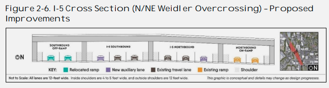
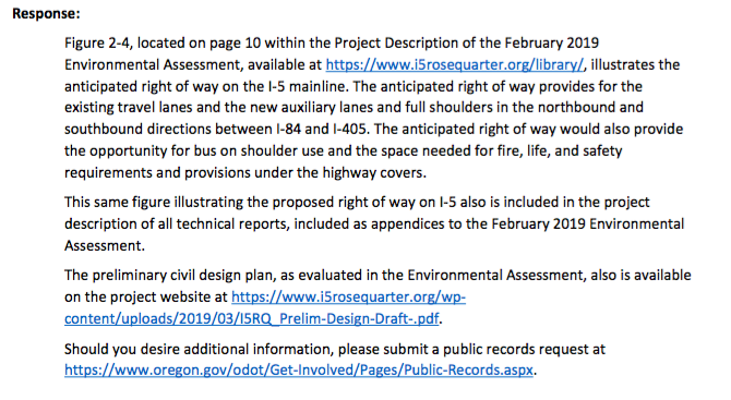
For your reference, Figure 2-4, located on page 10 within the Project Description of the February 2019 Environmental Assessment, available at https://www.i5rosequarter.org/library/, illustrates the proposed lane configuration which includes an inside and outside shoulder, two through lanes, and one auxiliary lane for the highway in each direction. All shoulders and lanes are 12 feet wide. The anticipated right of way would also provide the opportunity for bus on shoulder use and the space needed for fire, life, and safety requirements and provisions under the highway covers.”
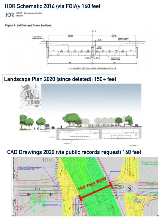
None of this, of course, was actually true. City Observatory obtained three different sets of documents prepared by ODOT contractors showing the actual width of the roadway to be approximately 150 to 160 feet. As early as 2016, the project’s contractors drew up plans for a 160 foot roadway–something that was never disclosed publicly by IBR, but which we obtained via a Federal Freedom of Information Act request. One of the project’s consultant’s drew up a landscape plan for freeway covers, clearly showing at 150 plus roadway (the contractor deleted this image from her website after we published this at City Observatory). Finally, CAD drawings prepared by the project, obtained by public records request show a 160 foot wide roadway.
What this really means is that the I-5 Rose Quarter project is easily large enough to include a ten-lane freeway. Here, we’ve adjusted the diagram contained in the original ODOT Environmental Assessment to accurately reflect the number of travel lanes that could be accommodated in a 160 foot roadway. This illustration contains generous inside and outside shoulders, as well as full 12-foot travel lanes. (Ironically, ODOT’s own design for the southern portion of the Rose Quarter project calls for 11-foot travel lanes on the viaduct section of I-5 near the Burnside Bridge).