Oregon and Washington are being asked to spend $7.5 billion on a giant bridge: Why won’t anyone show pictures of what it would look like?
The Oregon and Washington highway departments are using an old Robert Moses trick to make their oversized bridge appear smaller than it really is.
The bridge will blot out much of the reviving waterfront and downtown in Vancouver, and put Hayden Island in the shadow of a half-mile long viaduct.
The IBR has distributed misleading and inaccurate images of the proposed bridge, attempting to make it look smaller.
The agency is spending $1.5 million to create a “digital twin” computer model of the IBR, but is keeping it secret to avoid public scrutiny of its design.
Computer visualizations, complete with human-scale animations, are cheap and common for construction projects, such as Vancouver’s proposed waterfront public market–but ODOT and WSDOT have steadfastly refused to provide such visualizations for the IBR.
The proposed Interstate Bridge Replacement Project would be the largest and most expensive public works project in the Portland metro area’s history. You’d think that if you were spending $7.5 billion, you’d be proud to show the public and elected officials what it will look like. But in the case of the IBR, you’d be wrong. What do the Oregon and Washington highway department’s have to hide?
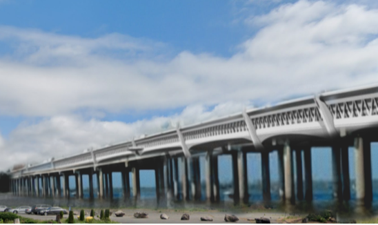
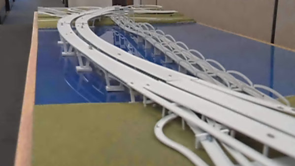
While the IBR project has only released distant aerial photos that make the project look tiny, we obtained a copy of a preliminary version of their 3D computer model, and used it to show how the view from Hayden Island changes with the construction of the new bridge. (You can use the slider to show how the view changes between the current bridge (on the left) and the proposed IBR (on the right).
[compare]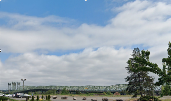
[/compare]
The striking difference in the height and scale of the two bridge images shown above contrasts sharply with the official image crated by IBR from the same digital model. They use the well-worn trick of showing the bridge, not from anywhere on the ground, or where humans are likely to see it, but from a point suspended in the sky, high above the project.
You’d have to be several thousand feet in the air to get this view of the IBR. This false perspective makes the bridge look tiny. It’s simply impossible to compare the height of the bridge, for example, to the height of buildings in downtown Vancouver, or get a sense of how much taller the freeway viaducts across Hayden Island are than any of the other structures on the island.
Blotting out the Vancouver waterfront
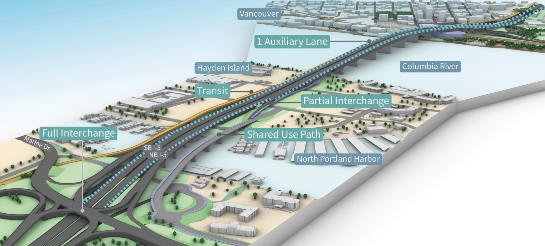
The proposed bridge will have a river clearance of at least 116 feet—the Coast Guard is asking for 178 feet—and the structure itself is a double-decker that will be between 35 and 40 feet tall, making the overall structure roughly 150 feet tall over much of the river. Because of that elevation, the bridge requires half-mile long viaduct approach ramps to get traffic from ground level north and south of the river, up to the high level of the crossing (the lengthy viaducts and elevated intersections are more costly than the bridge itself). This giant structure will tower over the Vancouver waterfront, which in the past decade has been the site of a remarkable urban redevelopment, with offices, shops, housing, and hotels.
Yet ODOT and WSDOT, who’s massive project will completely remake this part of the city has yet to provide a single illustration showing how the city would be affected. Again, using the IBR’s crude digital model, we were able to produce this image showing how the view along Vancouver’s riverfront will change if the IBR is built.
[compare]
 [/compare]
Just as a point of reference for local residents, the proposed IBR river crossing will be the size of three of Portland’s I-5 Marquam Bridges side-by-side. The massive new IBR bridge will tower over the waterfront, with associated noise and pollution. In addition, the viaducts leading to the bridge will be as high, and in some cases higher than adjacent downtown and waterfront buildings. Seattle just spent more than a decade and $3 billion to remove the Alaskan Way viaduct that blighted the city’s waterfront for more than half a century. Vancouver appears to be signing up to create the same kind of roadway scarred landscape that Seattle is trying to fix.
Using manipulated drawings to make the new bridge look smaller
The IBR project has purposely avoided providing an elevation, or profile view of the proposed bridge, in order to keep its height and bulk a secret. But a year ago, it did produce a profile drawing, but one that was purposely inaccurate. In March, 2022, when IBR as part of a navigation report with the US Coast Guard’s bridge permitting process, it produced an intentionally misleading drawing comparing the existing bridge and the new IBR. The image was dutifully published by the Vancouver Columbian (March 25, 2022):
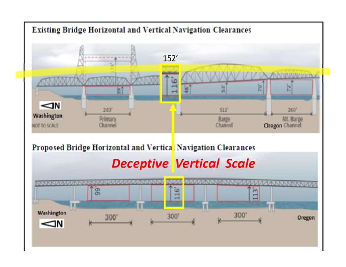
The diagram of the navigation clearance of the new bridge and old bridge, shown one-over-the-other uses different vertical scales to make the new bridge appear smaller and shorter than the old bridge. See this from CRC (yellow markings and red text are added by Engineer Bob Ortblad). The broad yellow band superimposed on the top diagram shows the true height and size of the new bridge. Notice that the top panel says “not to scale” and while the diagrams use the same horizontal scale, they use different vertical scales. This is intentional distortion.
A $1.5 million “digital twin”
This agency has no need of crude, not-to-scale drawings. It has detailed plans, and what’s more, buying a state-of-the-digital model of the bridge. IBR is spending $1.5 million to build a so-called “digital twin“—a deeply detailed computer model of every aspect of the proposed bridge, that will be used for design, construction, monitoring and maintenance. What, you might reasonably ask, is a digital twin? It’s not a mere computer model, it’s really much more complicated (and expensive) than that. IBR explains:
A digital twin, as envisioned in this project, is a portal (a 3D model of the bridge and other associated visual dashboards), through which authoritative data and information about the bridge and related road network can be accessed efficiently and quickly by authorized users along its entire lifecycle—from early project planning to real time operations. It is expected to not only serve as a digital record of the physical structure but also as a process twin whereby future “what if” scenarios related to design decisions, constructability, construction or maintenance activities, emergency operations, etc. can be simulated to a very high degree of precision
The contractor IBR hired to build the “digital twin,” WSP, touts its modeling as being an example of the “metaverse,” essentially a digital alternate reality:
Also today, we can use IoT and artificial intelligence [AI] to add data to visualizations and make decisions across departments; we can put ourselves inside of the virtual model of a city, for example, and interact with it—a process now called the metaverse; we can better relate the design to the context of the world around us We can test and validate elements of infrastructure—bridges, roadways, transit, and buildings—before construction;. we can create dynamic models that simulate and predict how these assets will perform in real-life contexts. Three-dimension reality models provide the basis for visualizing, collaboratively managing, and monitoring changes to infrastructure during the project and when the asset is in operation. (Emphasis added)
WSP has been working on the digital twin of the IBR for nearly three years, since at least June, 2020, according to company documents. WSP’s software vendor, Bentley, also flogs the IBR digital twin work in its promotional material, saying modeling tasks that formerly took months and months to do, can now be done instantly. In theory, the “digital twin” ought to be a way for the public to see exactly what the project will look like, from any angle, It is fully possible with such a model to create realistic, on-the-ground images and “walk throughs” of the project that convey exactly what it will look like. But that’s just a theory, because IBR has explicitly chosen not to create or share such images or visualizations with the public.
The digital twin is a secret
But IBR is doing its best to keep the “digital twin” and the images it would show of the IBR project a secret. At a March 16, 2023 meeting of a construction industry group in Seattle, IBR’s consultant, WSP, admitted that they were being told to keep the project under wraps so as not to provoke public outcry about the design:
Last night at Construction Management Association of America NW Chapter meeting Kevin Gilson, Director of Design Visualization at WSP USA, presented 3D/4D modeling. When he was asked about a 3D model for the Interstate Bridge Replacement (IBR), he said “Yes, but it isn’t public yet. There is a model on the website. It’s being produced by the communications team. There is a very detail 3D model. I was going to try and show it, but I am not working on that project. It’s very, very, it’s kept under wraps quite a bit, and I think it’s because of their experience with the first round, trying to tread carefully.”
Personal communication from Bob Ortblad, who attended this meeting, March 17, 2023 (Emphasis added).
City Observatory has filed a public records request to obtain a copy of the model. IBR officials have declined to provide that model until no earlier than the end of April, 2023.
Concealing images of the proposed giant bridges is a calculated PR strategy
The Interstate Bridge Project has contracted for nearly $10 million in public relations and communications consultants, and they’ve kept a tight lid on project images. A little over a year ago, the IBR project showed its first sketchy images of what the IBR project might look like. At the time, one of their public relations consultants, Millicent Williams, described the project’s desire to control the dissemination and interpretation of the images:
Thank you, Commissioner Berkman. I will share that the communications team has discussed, first of all the fact that once images like this get shared, there will be the opportunity for people to develop a narrative and we’re working to manage that— making direct contact with media outlets to ensure that they have the accurate information and are clear about what these images represent. Additionally we have asked that disclaimers drafts watermarks all the things that could make sure that folks know that this is not final. This is concept.
We recognize that there is the possibility that someone might have taken a screenshot of what we just shared and so hopefully, um, we can manage that messaging as well, and i’m sure that the team is prepared to do that but um that those are things that we’ve thought long and hard about because we want to make sure that we are not stymieing the process or the progress based on our failures to fully disclose where we are in the process and what these images represent.
IBR Executive Steering Group, January 20, 2022 (at 39:54)
Much smaller projects have sophisticated visualizations
Computer graphic simulations of new buildings and construction projects are commonplace—often as a sales and promotion tool. Developers want to let potential investors and local governments know what a project will look like before it gets built. That’s exactly what’s happening on the Vancouver waterfront—just not for the IBR project. The Port of Vancouver is building a new public market building—its take on Seattle’s Pike Place Market—at Terminal One (site of the now demolished Red Lion Hotel). The port’s architects prepared a detailed model of the public market building and the surrounding area, complete with a video “fly through” showing what the area will look like when the project is complete in a couple of years. You can even see the current I-5 bridge in their computer video.
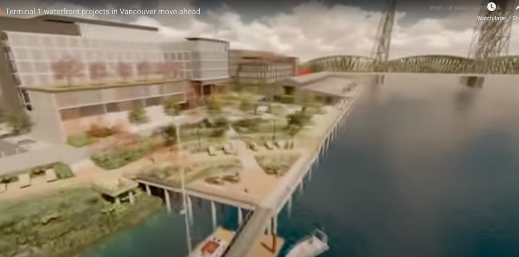
The total cost of the public market is on the order of $10 million—roughly the same as what the IBR project has spent on public relations in the past few years. Yet even though the IBR will cost about 750 times as much, and has such a copious budget for communication, it has not produced a comparable computer rendering, much less a human-level fly-through of the project.
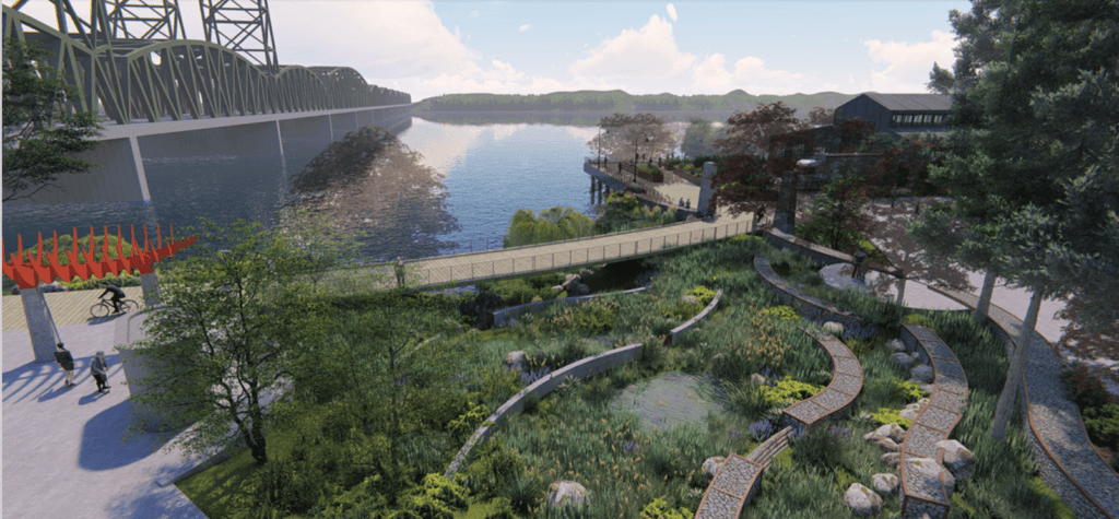
Ironically, the public market modeling doesn’t include the new Interstate Bridge, which will slice through and tower over the Vancouver waterfront. It will likely go right over the top of this particularly bucolic native garden:
The Columbia River Crossing images were hidden as well.
Hiding the images of what they are planning to build has been going on for more than a decade. In 2010, Columbian reporter Eric Robinson wrote a front page story for the Vancouver paper, noting that the project had done virtually nothing to show the visual impact of the giant new bridge on downtown Vancouver and its waterfront. He wrote:
Stand for a minute along Columbia Street near the railroad berm in downtown Vancouver.
Now look up.
A massive steel and concrete structure that today exists only in technical engineering schematics will materialize high above Vancouver’s riverfront within the decade if the proposed Columbia River Crossing sticks to its current schedule. The Interstate 5 bridge will deliver thousands of cars, heavy trucks and light rail trains into the city at roughly the height of an eight-story building.
Washington-based bridge architect Kevin Peterson is appalled.
“It looks like a big damn freeway crossing a railroad staging yard,” he said.
Vancouver Mayor Tim Leavitt acknowledged the new bridge will cast a long shadow. . . .
“It’ll be a monumental structure,” he said.
Yet, you’d scarcely know it by the tenor of public discussion.
Robinson, Erik, “Casting a long shadow.” Columbian; Vancouver, Wash. 01 Aug 2010: A.1.
City officials asked for a ground-level eye-view of the project, but were told it would be too expensive, and no renderings were produced. CRC official Carley Francis (now Southwest Washington WSDOT regional administrator), told Robinson that there was no guarantee they’d produce a street-level simulation of project before construction began in 2012, chiefly because the project—which at the time had spent about $134 million on planning—had “limited resources” to produce such a rendering.
Jonathan Maus, writing at Bike Portland (in 2013), reported much the same when he tried to find realistic and detailed images of the multi-billion dollar bridge project, as Oregon and Washington were being asked to fund the project:
You’d think that with all the support for the Columbia River Crossing down in Salem, lawmakers and their constituents would have a good idea about what their votes — and their tax dollars — will be going toward. But for some reason, CRC and ODOT staff have hidden the project from public view. Despite spending nearly $170 million on consultants and planning thus far, detailed renderings and/or visualizations of key elements of the project are nowhere to be found.
This is not typical of other large infrastructure projects across the country and it begs the question of whether or not CRC and ODOT staff are purposefully pulling the wool over our eyes. (emphasis added)
Our own work at City Observatory shows that the two state DOTs have been going out of their way to conceal what they’re planning to build, and to avoid showing how it will affect downtown Vancouver. For example, it took a public records request to learn that after promising to reduce the width of the CRC highway bridge from 12 lanes to 10 lanes, all the two DOTs did was erase all the references to the actual physical width of the bridge from the project’s environmental impact documents, while leaving in place plans to build a 180 foot wide highway bridge–enough for 12, or even 14 14 travel lanes.
At one point, the Oregon and Washington highway departments actually built a physical 3D model of the bridge. Photographs of the model were published by a local television station. But there are no photographs or other evidence of this physical model on the IBR or CRC websites.
The Long History of Using Misleading Images to Sell Urban Highways
Using this kind of illusion and creatively mis-representing the visual impact of a new construction has a long history in the world of selling highways. Robert Moses famously skewed the illustrations of his proposed Brooklyn Battery Bridge (which would have obliterated much of lower Manhattan and Battery Park); we turn the microphone over to Moses’ biographer Robert Caro, from The Power Broker:
Moses announcement had been accompanied by an “artist’s rendering” of the bridge that created the impression that the mammoth span would have about as much impact on the lower Manhattan Landscape as an extra lamppost. This impression had been created by “rendering” the bridge from directly overhead—way overhead—as it might be seen by a high flying and myopic pigeon. From this bird’s eye view, the bridge and its approaches, their height minimized and only their flat roadways really visible, blended inconspicuously into the landscape. But in asking for Board of Estimate approval, Moses had to submit to the board the actual plans for the bridge. . . .
The proposed bridge anchorage in Battery Park, barely visible on Moses’ rendering, would be a solid mass of stone and concrete equal in size to a ten-story office building. The approach ramp linking the bridge to the West Side Highway, a ramp depicted on the rendering as a narrow path through Battery Park, would actually be a road wider than Fifth Avenue, a road supported on immense concrete piers, and it would cross the entire park—the entire lower tip of Manhattan Island—and curve around the west side of the island almost to Rector Street at heights ranging up to a hundred feet in the air. Not only would anchorage and piers obliterate a considerable portion of Battery Park, they—and the approach road—would block off much of the light not only from what was left of the park but also from the lower floors of every large office building they passed; because the approach ramp was really an elevated highway that would dominate the entire tip of Manhattan, it would depress real estate values throughout the entire area.

