What City Observatory did this week
A yawning chasm in neighborhood distress among metro areas. Almost every metropolitan area has some neighborhoods that face serious economic distress, but the patterns of distress vary widely across the nation. We use data from the Economic Innovation Group’s latest distressed communities index to identify clusters of contiguous zip codes that are classified as distressed. We find that there is a more than order of magnitude difference in the degree of concentrated distress among Metro areas. The hardest hit metros have 20 percent or more of their population living in contiguous clusters of distressed zip codes. But nearly as many metros have almost no economic distress (with less than 2 percent of their population living in contiguous distressed zip codes)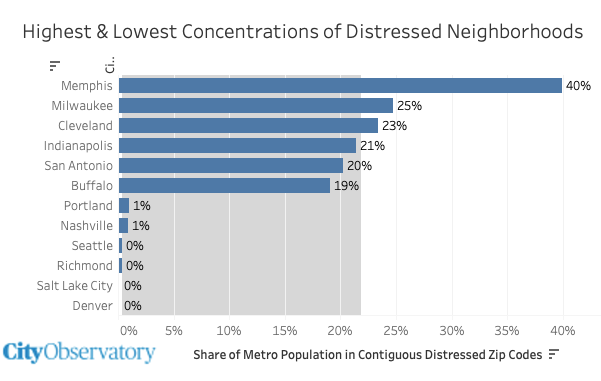 These data are a stark reminder that neighborhood level distress is a big problem in some metropolitan areas, but a much, much smaller problem in others. There’s powerful evidence that large and persistent concentrations of poverty have multi-generational effects. But in many metropolitan areas, economic distress is much more isolated, and is more about human capital than about geography.
Must Read
Housing markets explained using Legos. Governor Kotek patiently explains housing markets in terms anyone can understand. Housing economics often seem like a complex and daunting subject, but Oregon Governor Tina Kotek has a new video that succinctly explains housing affordability, the causes of displacement and how to solve both.

Using Lego’s Kotek demonstrates that when more people are seeking housing than the number of available homes, prices and rents get bid up, and those with the least resources are displaced. The solution is to add more homes, and we can do so through a variety of means: single family residences, duplexes, townhomes and apartments. For the record, City Observatory has some serious reservations about one part of the Governor’s plan: expanding urban growth boundaries around the state: the lack of housing at the urban periphery is not Oregon’s housing supply problem, and more sprawl poses a wide range of affordability, environmental and fiscal problems. That caveat notwithstanding, we applaud the Governor’s clear exposition of the importance of expanding supply, which can be done most importantly, by allowing more housing on land already designated and serviced for urban densities.
Hurray for HLA. This past week, voters in LA overwhelmingly voted to approve Proposition HLA, a measure requiring the city to implement plans to add bike and pedestrian improvements to city streets as they are rebuilt. Like many cities, LA has ambitious plans to add bike lanes and sidewalks, but these tend to get a very low priority (compared to maintaining and fixing stroads. Voters approved the measure notwithstanding a troubling opposition campaign highlighting opposition by local firefighters unions, which claimed the measure would increase response times.
 Voters didn’t buy these scare tactics, and voted almost two-to-one in favor of Measure HLA. It’s a reminder that parochial concerns of a few (usually parking spaces, or slower speeds) are much less important than addressing the profound safety deficiencies of our existing roads.
As active transportation advocates know, firefighters often claim that traffic calming measures like diverters, narrower lanes, traffic circles and bikelanes will somehow impede their over-sized vehicles. Not only is there no evidence that this is the case, but all these improvements directly reduce the number and severity of road injuries—and in virtually every community injuries and deaths in car crashes vastly outnumber the human cost of fires. Firefighters ought to know this—they respond to car crashes much more than building fires.
Your small apartment is really as big as your city. There have been social media stories rediscovering that Tokyo has many small apartments—as small as 300 square feet. To some, such small apartments are emblematic of a terrifying prospect of cramped living. But as Noah Smith—who lived in such a Tokyo apartment for a year explains, the size of the apartment is really secondary to the urban amenities that surround it. Especially if you’re young, and single, and not wealthy, being able to afford a place of your own that puts you in the middle of shops, restaurants, parks, jobs, and close to other people who share your interests, 300 square feet is an abundance of space. You spend most of your time elsewhere.
As Smith notes there’s a contrast between where we spend the bulk of our time in the US compared to Japan:
America is a place where you live INSIDE—inside your house, your car, your office, or maybe a mall.
Japan is a place where you live OUTSIDE, in public spaces that are made to provide you with both adventure and comfort.
And no one is “forced” to live in a small apartment: these micro-apartments provide choices to those who wouldn’t otherwise have them. For too long, housing policy in the US has decided that smaller and shared living arrangements, like single room occupancy buildings, were “substandard” and made them illegal—without providing affordable alternatives. A small apartment one can afford is preferable to living on the street, or being forced to live far from the opportunities, amenities and people who live in your city.

New Knowledge
City Density Gradients
One of the key measures of urbanism is density. As Economist Ed Glaeser says, cities are the absence of space between people. Jonathan Nolan has created a great new tool for visualizing the differences in density across cities and metropolitan areas world-wide. The tool features a density gradient—a line representing the average density of each city based on the radial distance from the center of the region. As a rule, densities tend to be highest in the urban center, and then taper off the further one moves away from the center.
CityDensity.Com allows you to observe the density gradient for most of the large cities around the world, and compare different metropolitan areas. Its charts are instructive in a couple of ways. First, they illustrate the absolute differences in density across metro areas. US Metro areas are uniformly less dense than their counterparts in most of the rest of the world. Second, it’s useful to compare the slope of the density gradient across cities. Some places are highly peaked, with high levels of density in the center; while others tend to be much uniform and “flatter.”
City Density lets you look at overall population density, population-weighted density (the density experienced by the average person), and density measures that exclude bodies of water.
The charts show just how different some of the world’s great cities are from typical American cities. There are more people, and in particular, much more people close to the center. Here’s a chart showing Paris, New York and Houston. In their centers, New York and Paris have high levels of density; Houston, like may US metros, is basically flat, with central densities levels basically no higher than at the periphery.
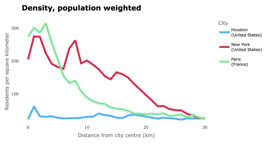
The City-Density charts also serve as an informative counterpart to one of urbanist social media’s favorite tropes: superimposing the rail network from some livable European city with a similarly sized but car-dependent American counterpart. Why can’t we, with about the same population, support a similar rail network, these comparisons ask? The density charts provide a compelling answer: cities with great rail systems also have high levels of density; car dependent sprawl is difficult or impossible to serve economically.
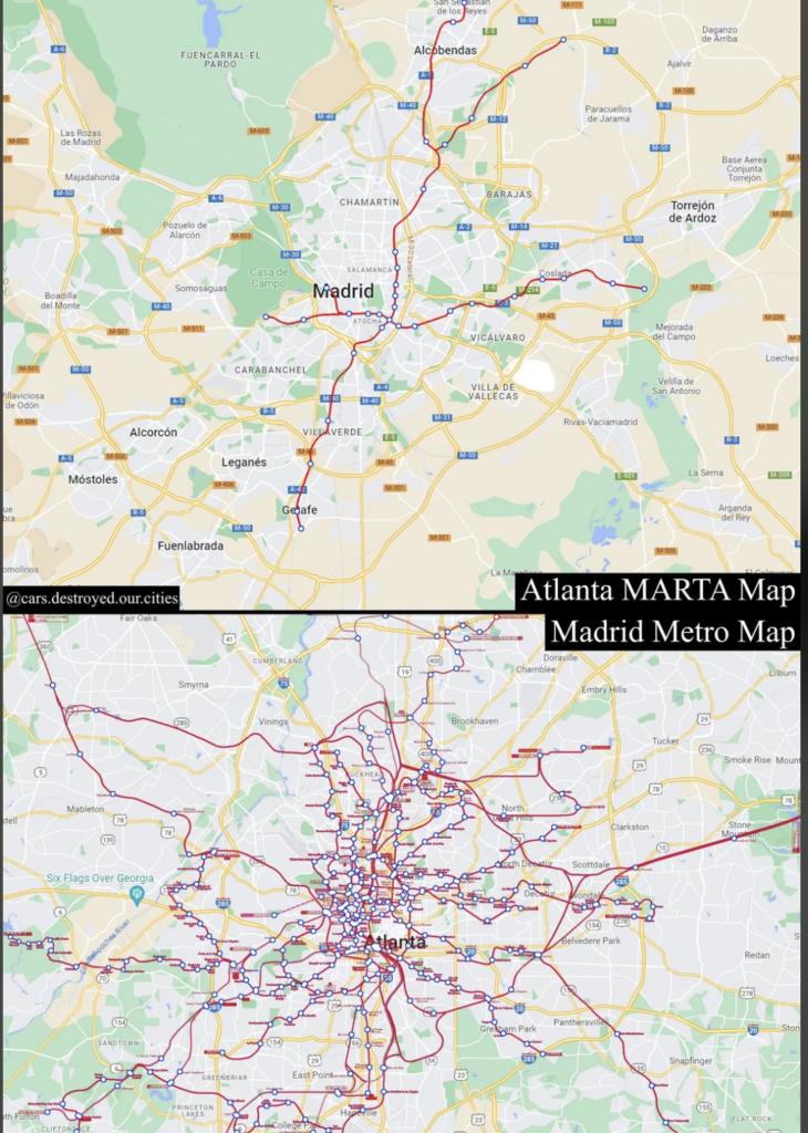
Rail Networks: Madrid and Atlanta
The implication the map posted to Reddit (below) is that Madrid and Atlanta have roughly similar populations, but that Atlanta has a tragically sparse rail network. Why couldn’t it be more like Madrid, which is covered in a dense mesh of rails?
Population Density
Comparing the population densities of the two regions provides a good explanation: Madrid has high levels of density in the center, not unlike New York and Paris, while Atlanta is flat, and less dense than Madrid even 20 miles (30 kilometers) from its center.
: Madrid and Atlanta
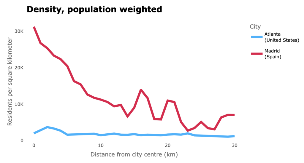
To be sure, there’s a chicken-and-egg problem here: Density makes a strong rail network viable, and a robust rail network makes density more attractive. Too many US metro areas are stuck in a place where its difficult to build rail networks and denser housing.
