What City Observatory did this week
Climate fraud in the Portland Metro RTP. Metro’s Regional Transportation Plan rationalizes spending billions on freeway expansion by publishing false estimates and projections of greenhouse gas emissions. Transportation is the number one source of greenhouse gases in Portland. For nearly a decade, our regional government, Metro, has said it is planning to meet a state law calling for reducing greenhouse gas emissions 75 percent by 2050. But the latest Metro Regional Transportation Plan (RTP) has simply stopped counting actual greenhouse gas emissions from transportation.
Inventories compiled by the state, the city of Portland and the federal government all show the region’s transportation emissions are going up, not down as called for in our plan. In place of actual data, Metro and other agencies are substituting fictitious estimates from models; these estimates incorrectly assume that we are driving smaller cars and fewer trucks and SUVs, and rapidly replacing older cars. None of those assumptions are true.
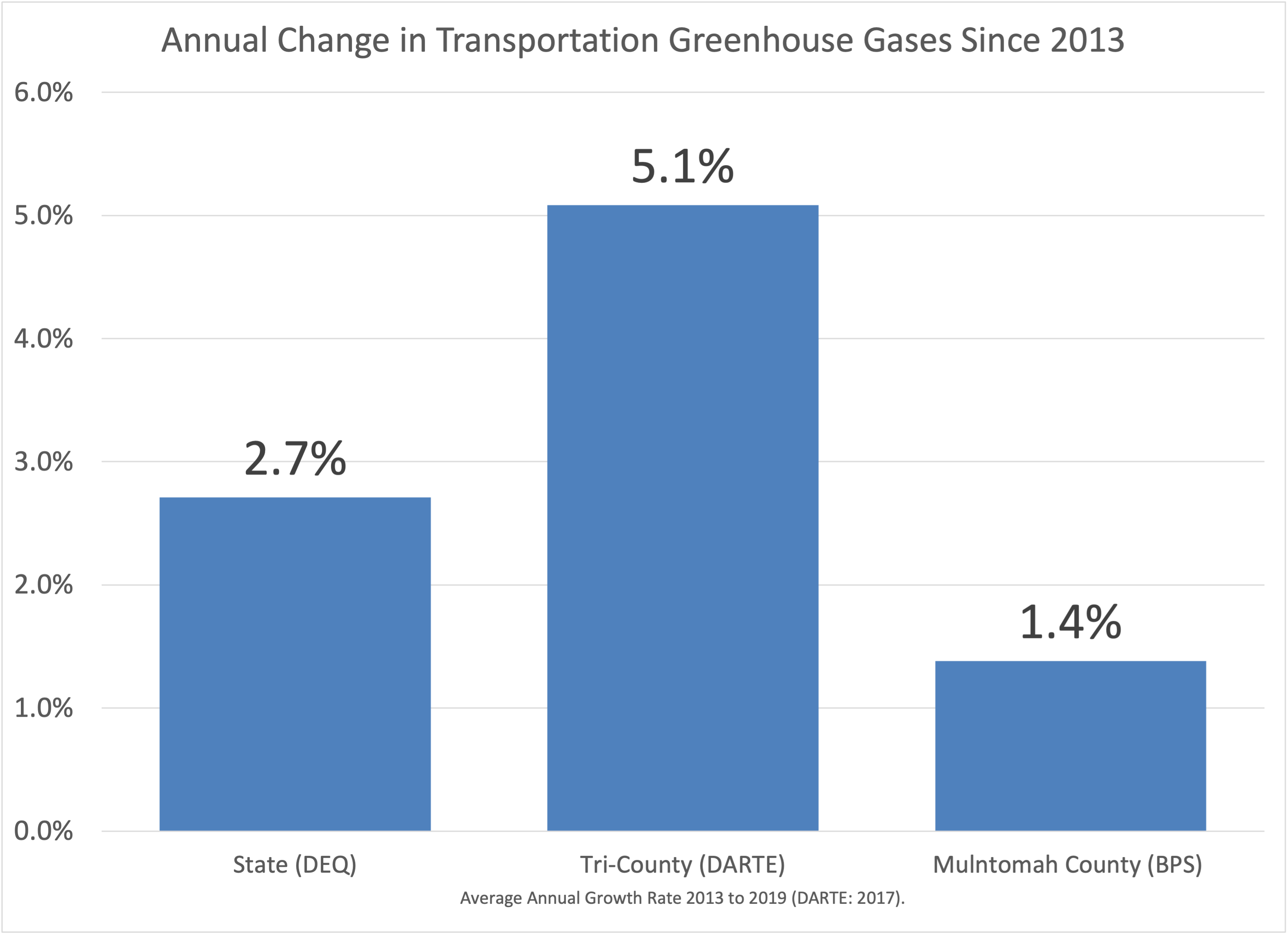
As a result greenhouse gases are going up; our plans are failing, and Metro’s Regional Transportation Plan, the blueprint for spending billions over the next several decades will only make our climate problems worse
Must Read
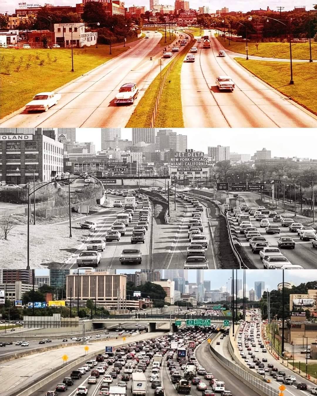
The futility of freeway expansion, in three pictures. Darren Givens (@atlurbanist) has a succinct and powerful social media post visually demonstrating Atlanta’s futile efforts to reduce congestion by widening freeways through the city. To paraphrase Don Shoup, wider freeways have been a fertility drug for traffic.
How freeways destroy urban housing wealth. Bloomberg’s CityLab reports on a new study from Transportation for America documenting the destruction of housing wealth by freeway construction in US cities. Taking a close look at the housing demolished to provide space for freeways in Washington, DC, and Atlanta, the author’s conclude that freeway construction destroyed billions of dollar in home value, based on today’s value of urban housing.
In DC, those two [the Southeast and Southwest Freeways] interstate sections eliminated at least $1.4 billion in home value based on today’s market. They also cost the city at least $7.6 million in annual property taxes (based on the 2023 residential property tax rate of 0.54%).
Other research has shown that the direct demolition of houses in the highway right of way is just the tip of the proverbial iceberg. Neighborhoods divided by urban freeways and inundated by traffic tend to go into terminal decline. Researchers at the Philadelphia Federal Reserve Bank found that the urban neighborhoods closest to freeways suffered the biggest declines in population of any urban neighborhoods. Continued spending on highway capacity in urban areas is a value destroying activity.
New Knowledge
Zoning and educational inequality. The geography of American cities both typifies and reinforces economic inequality. Higher and lower income people live apart from one another in most metropolitan areas, and the balkanization of locally provided services, especially education, amplifies these inequalities. People who live in low income communities get worse public services, and have fewer opportunities to get the education or jobs that would allow them to advance.
A new paper from Richard Kahlenberg draws a direct line between exclusionary single family zoning and the geography of inequality. Requiring large lot, single family housing, and mostly (or entirely) banning apartments in many suburban jurisdictions both precludes many lower and moderate income families from living in such places, and enables the residents of those places to enjoy a higher level of public services, especially schools, while restricting the access of lower income households to amenities jobs and education.
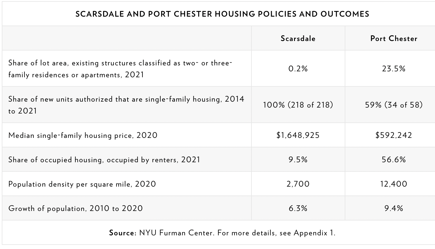
Kahlenberg looks closely at Westchester County, a suburb of New York City, and compares the zoning, schools and demographics of two of its cities, Scarsdale and Port Chester. Scarsdale is wealthier, whiter and more expensive; Port Chester is poorer, less white and less expensive. Scarsdale has little multi-family land, and large minimum lot sizes, as much as two acres, even near commuter rail stations. Little wonder that fewer than 10 percent of Scarsdale residents are renters, while a majority of Port Chester residents rent. Statistically, the contrast is striking:
Its little surprise, then that places like Scarsdale are bastions of NIMBY opposition, both to denser housing, and to statewide efforts to reform zoning, like Governor Kathy Hochul’s recently defeated housing plan. While their arguments are cloaked in an ostensible desire to protect unique local character, its clear than zoning serves as a tool of exclusion and opportunity hoarding.
As xxxx points out, Brown v. Board of Education outlawed the use of race as a basis for segregation, but since then local policies have enshrined economic status in its place.
In the news
The Oregonian published an Op-Ed—”Oregon’s funding plan for the I-5 bridge is a generational crime”—by City Observatory Director Joe Cortright, about the state’s plan to subsidize the I-5 Bridge Replacement Project with $1 billion of general obligation bonds.
KGW-TV featured City Observatory Director Joe Cortright in its reporting about the reasons for the $6 billion cost of the Interstate Bridge Replacement project (really a 12-lane wide, 5 mile long freeway, that involves rebuilding seven different interchanges).
