What City Observatory did this week
The Opposite of Planning: Why Portland’s Metro government needs to turn down the highway department request for more money to plan future freeway widenings. On paper, and to admirers, Portland has a pretty potent regional government. Metro is directly elected, and empowered to make important regional transportation decisions. It’s being asked by the Oregon Department of Transportation to bless spending a tranche of $36 million (out of an anticipated bill of $200 million) just to plan a revival of the failed I-5 Columbia River Crossing project (which will ultimately cost upwards of $5 billion). We outline the reasons Metro should say “No!;” all of them are core to Metro’s professed commitment to planning.
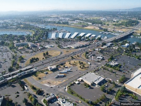
The project is based on 15-year old traffic data used to create obsolete models, it fails to incorporate what we no about induced demand, and how larger freeways simply generate more traffic and increased greenhouse gas emissions. Despite the fact that the state and region have said they’re going to use road pricing, the project’s planning has failed completely to consider how pricing will affect road use, and how it may reduce or eliminate the need for added capacity. All this spending on roads flies in the face of supposed commitments (Hello, Glasgow!) to address climate change. Finally, the Oregon and Washington DOT’s don’t actually have a serious financial plan for the $5 billion cost, and to add insult to injury, they’re asking Metro to divert money from maintaining existing roads to subsidizing the planning for this expansion. It’s the opposite of planning.
Must read
1. The problem with minimum bike parking requirements. The hegemony of the automobile in urban transportation leads some to assume that, logically, promoting other modes requires somehow repeating for bikes or walking or transit the preferential policies that have favored cars. One case in point: bike parking requirements. Some communities now look to stimulate bike use by mandating bike parking as a condition of land use approvals. While superficially that may seem fair, New American Planning argues that the trouble is the connection between biking and particular land uses varies substantially from place to place, and we don’t have a really valid baseline for judging how much parking is really needed or useful.
New Knowledge
Cities grew and and became more diverse over the past decade. Brookings Institution demographer Bill Frey has a look at the trends population growth and in the racial and ethnic composition of large US cities based on the latest 2020 Census data. In general, over the past decade, large US cities added more residents, and also became more diverse. Of the 50 largest cities, 46 gained population in the decade between 2010 and 2020; and population growth in these cities was collectively faster in the past ten years (8.5 percent) than in the ten years from 2000 to 2010 (5.6 percent). In addition to accelerating population growth, large cities led the nation in increased diversity.
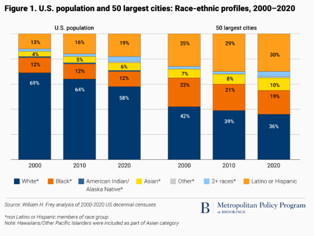
Over the past two decades, the share of the population that is Non-Hispanic white in large cities has declined from about 42 percent to 36 percent. In the aggregate the 50 largest cities are now a little more than one-third Non-Hispanic White, a little less than one-third Hispanic, about 20 percent Black and about 10 percent Asian. While the trend of increasing diversity is playing out nationally, these large cities are considerably more diverse than the nation as a whole.
Not surprisingly, increasing racial and ethnic diversity shows up most in the younger residents of cities. Among younger age cohorts, the fraction of the population that is Black, Hispanic or Asian is higher than it is for older age cohorts.
It is important to emphasize that these are data for the population inside the city limits of the largest cities. As we’ve frequently noted at City Observatory, municipal boundaries capture widely varied portions of their metro areas; some large cities encompass much of their region, including lower density suburban style development; while in other places, the largest city is just the higher density, older urban core.
William H. Frey, 2020 Census: Big cities grew and became more diverse, especially among their youth,
Brookings Institution Report, October 28, 2021
In the News
Streetsblog republished our essay calling out the one place where socialism flourishes in America: in parking.
Strong Towns republished our commentary “Ten reasons not to trust your state DOT claims about highway widening.”
