What City Observatory did this week
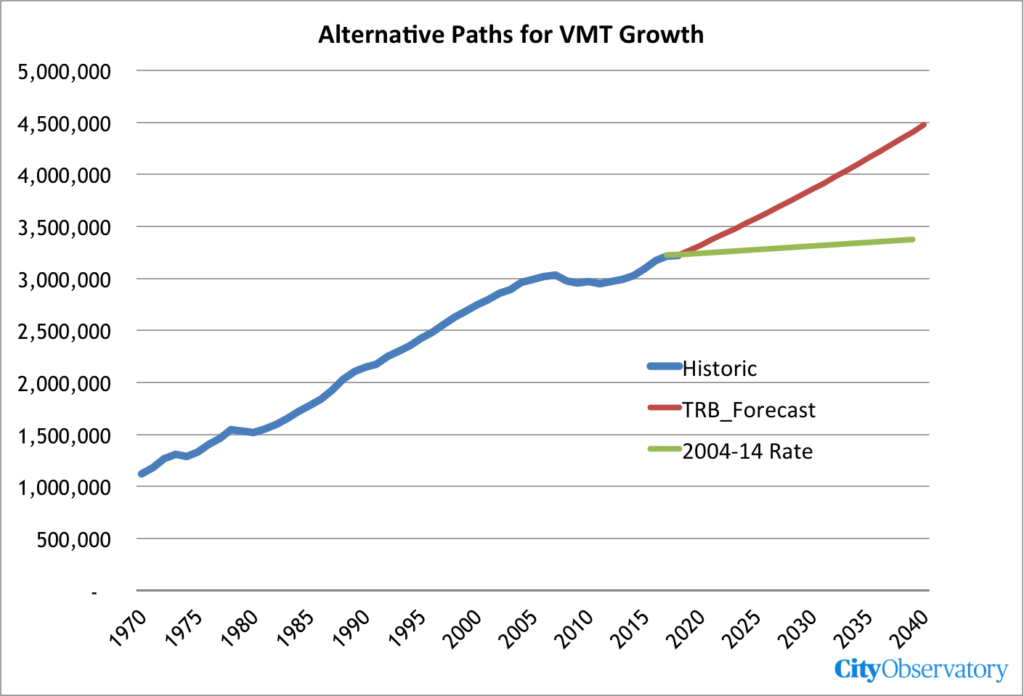
1. Highway to Hell. There’s a new report out on the the future of the Interstate Highway System, and its a shocker. It’s a shock because it shows that the National Academies of Engineering, ostensibly a pillar of the nation’s scientific establishment, is willfully blind to the problems of climate change, and unwilling to consider, even for a moment, reducing driving as a way of, you know, saving the planet. Instead, they call for doubling down on interstate highway building; doubling or tripling the amount of money spent on road construction, and facilitating an additional 1.25 trillion miles of driving per year. It’s a prescription that could just as easily have been written for the 1950s, but by 2050, is a recipe for climate disaster.
2. Seeing red. More than 900 Americans were killed by people running red lights last year. Despite our fascination with so-called “smart” technology, we’ve been loathe to apply it to the most basic tasks of promoting safety by ensuring compliance with existing laws. If we want a safe and smart transportation system, we ought to make greater reliance on well established technologies like speed and red light cameras.
Must read
1. A comprehensive debunking of the Texas Transportation Institute’s Urban Mobility Report. From that worthwhile Canadian Initiative, the Victoria Transportation Policy Institute, we have an updated, point-by-point takedown of last month’s TTI Urban Mobility Report. Todd Litman of VTPI catalogs the reports flaws: the report considers only car traffic, measures mobility, rather than accessibility (which is what people value), overestimates baselines speeds and the value of travel time savings, and exaggerates fuel savings and pollution reductions, and ignores the effect of induced demand from increased highway capacity.
2. Bruce Schaller piles on the Texas Transportation Institute. A key claim of the Urban Mobility Report is that traffic is leading to ever-lengthening commutes, as drivers face more and more delay on major roads. There’s a problem with that claim, though, simply doesn’t square with Census data on self-reported commute times. TTI claims, for example, that time lost to traffic delays have increased 42 percent in Houston in the past decade, but Census data for the same time period show that the average commute time increased just 6 percent. (Our 2010 report also showed that earlier TTI claims couldn’t be squared with independent sources of data). Schaller reflects on the calls in the TTI report (and elsewhere) for a “balanced” transportation system, but argues sprawl is the underlying cause of tedious commutes and that the key to reducing time spent in traffic is to build denser cities.
But there is really only one solution. That’s to put people—and jobs—back in the core of metro areas. Increasing the thread count in the existing fabric of people and jobs in cities and close-in suburbs will create the conditions that transit needs to thrive: lots of people going every which way, scarce parking, and bad traffic. A thick urban fabric has been the recipe for successful transit ever since horsecars, cable cars, and eventually streetcars enabled cities to expand beyond a walking radius.
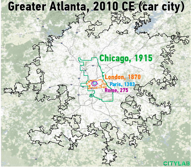
3. Marchetti’s constant, illustrated. One of the simplest and most profound observations about the connection between transportation technology and urban form is “Marchetti’s constant”–the fact that throughout history, and regardless of the available modes of transportation, the time humans allocate to daily travel works about to about 30 minutes, one-way. Early cities were smaller, denser and more compact, and as transportation improved, cities became progressively larger and less dense. In an essay at CityLab, Columbia University PhD candidate Jonathan English shows how each successive generation of technology–steam trains, urban streetcars, and the combination of cars and freeways–expanded the size of the metropolis as they increased the distance a person could travel in about 30 minutes.
The approximate boundaries of Rome (during its imperial zenith), Paris in the 14th century, London in the Victorian era, Chicago after the turn of the twentieth century, and Atlanta today, are superimposed at the same scale. Its a helpful reminder of the knock-on effects of changes in transportation technology and economics–better transport tends to induce demand to travel further, subject to the 30 minute time budget humans allot to daily travel.


