Big money “pedestrian” projects are often remedial and performative; their real purpose is to serve faster car traffic.
One of the biggest lies in transportation planning is calling something “multi-modal.” When somebody tells you a project is “multi-modal,” you can safely bet that its really for cars and trucks with some decorative frills appended for bikes and pedestrians. A four- or six-lane arterial, posted for 45 miles per hour, and with crossings every half mile or more isn’t pedestrian friendly no matter how wide the sidewalks are on either side of the road.
Much of what is labeled pedestrian infrastructure is in reality car infrastructure. In a place populated entirely by pedestrians and bicycles, for example, there’s no need for wide rights of way, grade separations or traffic signals. In even the most crowded cities, people simply walk or ride around one another. If its just people walking, there aren’t even lane markings. Humans have long had the ability to avoid collisions, using subtle visual cues. Pedestrian friendly places don’t need elaborate infrastructure.
When we build a sidewalk along a busy arterial, or put in a traffic signal or build a pedestrian overpass, we may call it “pedestrian” infrastructure, but the only reason it’s actually needed is because of the presence and primacy of cars. And its purpose is primarily to benefit cars, speeding car travel, by freeing them from the need to pay attention to or yield to pedestrians (or to only have to do so under strictly limited conditions). If a pedestrian crosses outside a sidewalk, or against a light, the law routinely exempts vehicle drivers from any penalties from hitting or killing them.
Most elaborate “pedestrian” infrastructure is really car infrastructure. As an example, lets have a look at Lake Mary, Florida, a suburb of Orlando. Like much of suburban Florida, Lake Mary is a grid of multi-lane arterials. One of the city’s highest crash locations, according to its transportation plan, is the intersection of Lake Mary Boulevard and Country Club Road. Lake Mary Boulevard is 7-lanes wide, with turn-lanes and through traffic lanes, and is a daunting obstacle for pedestrians, so the city has constructed two pedestrian bridges over the highway, with a 153-foot span.
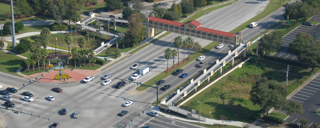
The engineering firm that built the crossing describes it as a “having a Mediterranean/Italian style.” and touts its “highly decorative safety enclosure and decorative cladding walls .” Anyone who has ever walked for five minutes in an Italian city will be hard pressed to find any substantive resemblance. The ramps needed to reach the elevated structure roughly triple the crossing distance for pedestrians, which probably explains while people still use the grade-level crosswalk.
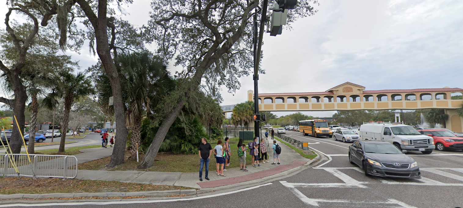
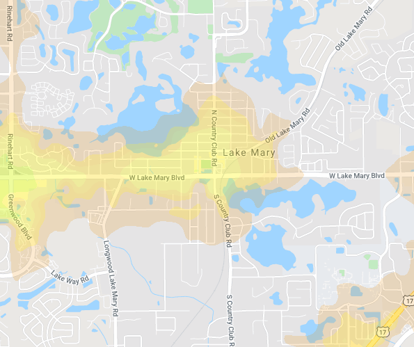
These elaborate and expensive pedestrian bridges are at best a remedial effort to minimize the danger this environment poses to anyone who isn’t in a car. They don’t really make the area any more desirable for walking. The real problem is not the infrastructure, or lack thereof, but a built environment that’s inhospitable to walking and cycling. Even the densest parts of Lake Mary get a Walk Score of 49 “car dependent” and most housing has Walk Scores of 20 or less, meaning that people need a car for almost all of their basic travel. Here’s a heat map, the yellow and red areas have Walk Scores of less than 50 (car-dependent), the gray areas are below 10.
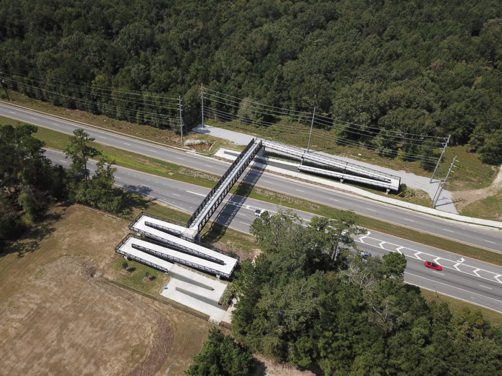
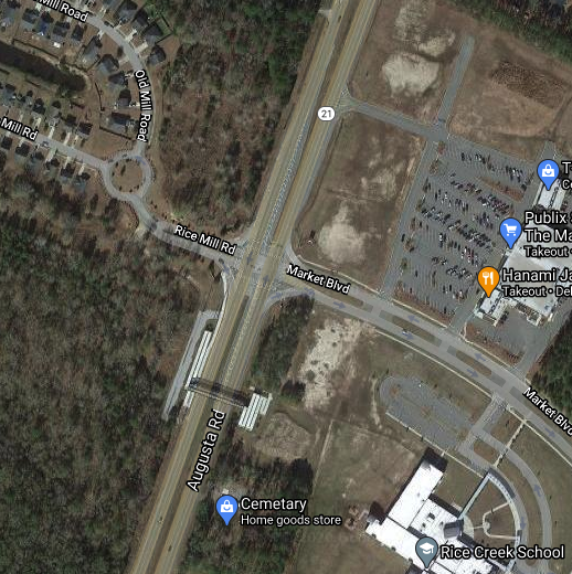
Here’s another, example, from Port Wentworth, a suburb of Savannah, Georgia. Here, the Georgia Department of Transportation has built a $4 million pedestrian overpass over a four-lane highway, Augusta Road (GA-21). The bridge’s 178-foot span connects a new residential subdivision on one side of the highway with other subdivisions and a local school on the other. The overpass features lengthy serpentine switchbacks on both sides, more than quadrupling the distance one has to walk as opposed to using the highway’s crosswalk.
The total population of Port Wentworth (in 2018) was about 8,500 persons, so the $4.1 million cost of the overpass works out to about $500 per capita. Few if any cities in the US spend so much per capita on “walkability.”
But Port Wentworth is anything but walkable. Redfin calculates the city’s overall Walk Score as 20. Of the apartments for rent on either side of Augusta Road, a handful have scores in the low teens; most are under ten, and several have a Walk Score of “1” the lowest possible score. Even with a prodigious investment in “pedestrian” infrastructure, this is not a place for people walking or biking.
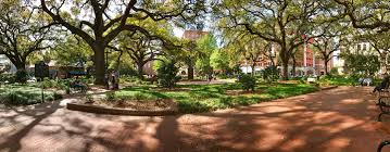
The irony of course is that Port Wentworth is a suburb of one of America’s most delightfully walkable cities, Savannah. The indelible imprint of its 18th Century town planning with regular squares, tree-shaded streets and a mix of housing, all laid out for walking–no $4 million highway over-crossings to be seen. Hundreds of thousands of tourists come to Savannah each year, mostly just to walk around, in a way that’s impossible nearly anywhere else in North American city, in neighborhoods that are illegal to build in almost every municipality.
“Pedestrian infrastructure” is an oxymoron. In a place that’s hospitable to people and walking pedestrians don’t need separate “infrastructure”—they can use the streets as a place to walk, just as humans have done for the several thousand years in which there were cities but no cars.
Much of what purports to be “pedestrian” infrastructure, is really car infrastructure, and is only necessary in a world that’s dominated by car travel, in places that are laid out to privilege cars. It’s telling that the “level of service” provided to pedestrians (nominally for their safety) would never be tolerated in any freshly built or “improved” highway project: The the ramps to reach overpasses double, triple or quadruple the distance a pedestrian must travel to cross a roadway, and require them to ascend and descend a substantial grade. No highway engineer would build a bypass that doubled or tripled travel times for cars, but they regularly do this for people on foot.
A somewhat better form of pedestrian “infrastructure” if we actually could create such a thing, might look more like raised crosswalks. Sandy James has a nice definition. Raised crosswalks, she writes:
. . . are walkable speed humps that are at the same grade as the sidewalk on either side of the street. The raised crosswalk serve to elevate the pedestrian, and slow vehicular traffic . . .

Raised crosswalks make a space more comfortable for pedestrians, and marginally slower for cars. But perhaps most importantly the raised crosswalks redefine the “ownership” of space; they signal to drivers and pedestrians alike that the walkers have priority: that cars are driving across a sidewalk, rather than pedestrians are walking across a road. Curbs (and curb cuts) signify to everyone that pedestrians are stepping out of “their” space, and into the space “owned” by the driver. But in the US, raised crosswalks are extremely rare. Again, though, raised crosswalks are really only necessary because of cars, so they are actually car infrastructure, not pedestrian infrastructure.
The takeaway here is that real pedestrian infrastructure is about a dense, mixed use area that shuns or at least slows private automobiles. A place with a mix of housing types (apartments, duplexes or triplexes and single family homes), local-serving businesses, and a grid of streets, rather than the rigid, hierarchical arterial/collector/cul-de-sac model of most post WWII US suburbs. It’s about neighborhoods like old Savannah, where people don’t have to cross multi-lane arterials to shop, attend school or visit a public park. Walkability and pedestrian safety are really about building great places, not more infrastructure.
And that, it a nutshell, is one of the big problems with Portland Metro’s proposed $5 billion transportation ballot measure. It proposes spending lots of money on “pedestrian” improvements to a series of highway corridors, the multi-lane, car-dominated arterials that slice through the region. They are undoubtedly a safety menace. But money for wider sidewalks, better illuminated crosswalks, and even grade separated crossings like those shown above won’t do much, if anything to make these areas or the region more walkable, because in the end, these corridors are still dedicated to moving lots of cars as fast as possible. If the region really wants to promote walkability, it needs to focus on building places, especially town centers and main streets, where car traffic is shunted or shunned, and people on foot or on bikes are the dominant and prioritized use. Its about place—not “infrastructure.”
