ODOT’s proposed relocation of the I-5 Southbound off-ramp at the Rose Quarter will add 1.3 million miles of vehicle travel to local streets each year.
Moving the I-5 on ramp a thousand feet further south creates longer journeys for the 12,000 cars exiting the freeway at this ramp each day.
The new ramp location requires extensive out-of-direction travel for all vehicles connecting to local streets.
With more miles driven on local streets, and more turning movements at local intersections, hazards for all road users, but especially persons biking and walking, increase substantially.
More driving on neighborhood streets increases local pollution and greenhouse gas emissions.
In an effort to get more space to expand a proposed freeway cover, the Oregon Department of Transportation is proposing to move the southbound off ramp from I-5 at the Rose Quarter nearly half a mile south. The new location’s awkward location in relation to the city’s established street grid creates a hazardous hairpin turn, and also lengthens the trips freeway exiting travelers will take, regardless of the direction they travel.
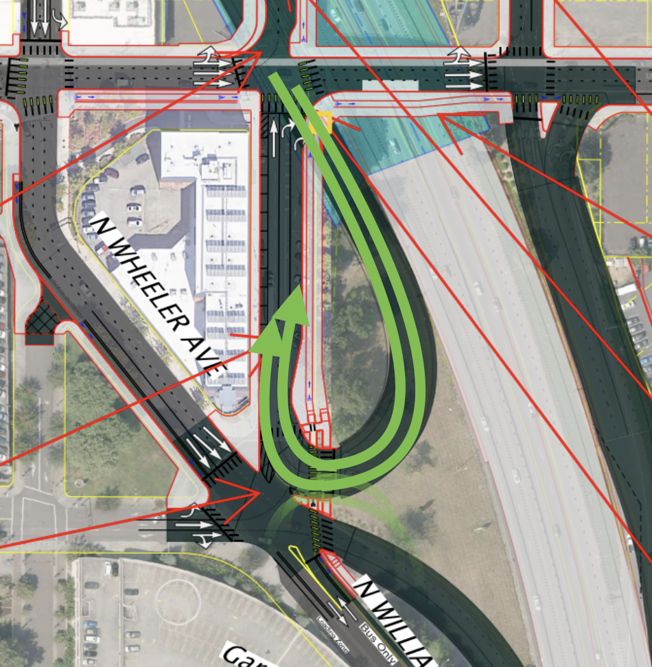
The underlying problem is that the major arterial streets leading away from the freeway are all considerably north of the new proposed off ramp location, meaning that all travelers will have to travel further to connect with these arterials than they do today. Once they transit the hairpin turn, all vehicles have to travel northbound on Williams Avenue as far as N. Weidler in order to go east, and a block further to N. Broadway in order to go west.
We estimate that the additional travel associated with the new off-ramp location will result in more than a million additional miles of vehicle travel in the Rose Quarter neighborhood each year.
Estimating additional travel
Vehicles leaving I-5 can travel in four cardinal directions: North on Williams Avenue, east on Weidler Avenue, west on Broadway, or south on Wheeler the two-way segment of Williams Avenue. The new ramp configuration requires a longer and more convoluted routing to reach each of these arterials.
We’ve used Google maps compute distance function to compute the additional distance vehicles must travel from the proposed new I-5 southbound off-ramp to each of these streets. Eastbound and northbound vehicles exiting I-5 southbound will have to travel an additional 1,000 feet from the new ramp location. Westbound and southbound vehicles exiting I-5 southbound will have to travel an additional 2,000 feet from the new ramp location. (We show the computation of the net added travel distances for each route in the maps below).
Data collected by the Oregon Department of Transportation show that about 12,530 vehicles per day exit Interstate 5 at the existing southbound off-ramp (Exit 302A). ODOT’s data don’t differentiate traffic according to their turning movements subsequent to leaving the freeway. For simplicity, we assume that one-fourth of this total exits in each of the four cardinal directions, or about 3,100 vehicles per direction.
The following table shows the additional distance traveled due to the proposed new I-5 southbound ramp location. For example, about 3,133 vehicles traveling northbound travel an additional 1,000 feet each day, for total additional vehicle travel of about 3.1 million feet (or a little less than 600 miles). Aggregated across all four cardinal directions, the new ramp location leads to an additional 18.8 million feet or 3,600 miles of vehicle travel per day in the Rose Quarter neighborhood. On an annual basis, this works out to more than 1.3 million additional vehicle miles of travel.
| Direction | Traffic | Added Distance (feet) | Total Distance (feet) |
| North | 3,133 | 1,000 | 3,132,500 |
| South | 3,133 | 2,000 | 6,265,000 |
| East | 3,133 | 1,000 | 3,132,500 |
| West | 3,133 | 2,000 | 6,265,000 |
| Total | 12,530 | 18,795,000 | |
| Miles/Day | 3,600 | ||
| Miles/Year | 1,300,000 |
More Traffic, More Turns, More Crashes, More Pollution
Adding 1.3 million miles of vehicle travel to the already congested Rose Quarter area will have predictable negative effects on the environment, safety and walkability. As we’ve noted, the ODOT’s plans call for closing some crosswalks, and cutting back corners on 13 blocks to create a wider turning radius to speed cars. Those wider intersection will have longer crossing distances, and pose greater dangers for people walking in the neighborhood. This problem is amplified by both the additional travel, and the increased number of turns required to leave the freeway to reach any arterial—and each turning movement creates additional dangers for pedestrians and cyclists. These safety problems are in addition to the likely increase in crashes due to the dangerous hairpin turn exit created by the new I-5 southbound ramp location.
The increase in driving also means an increase in pollution. Each mile of vehicle travel produces about 411 grams of greenhouse gases. That means the added driving on local streets in the Rose Quarter will add more than 500 tons of greenhouse gas pollution each year. There is no indication that the project’s Environmental Assessment contains any analysis of this increase in greenhouse gases as a result of this project.
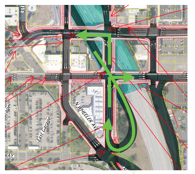
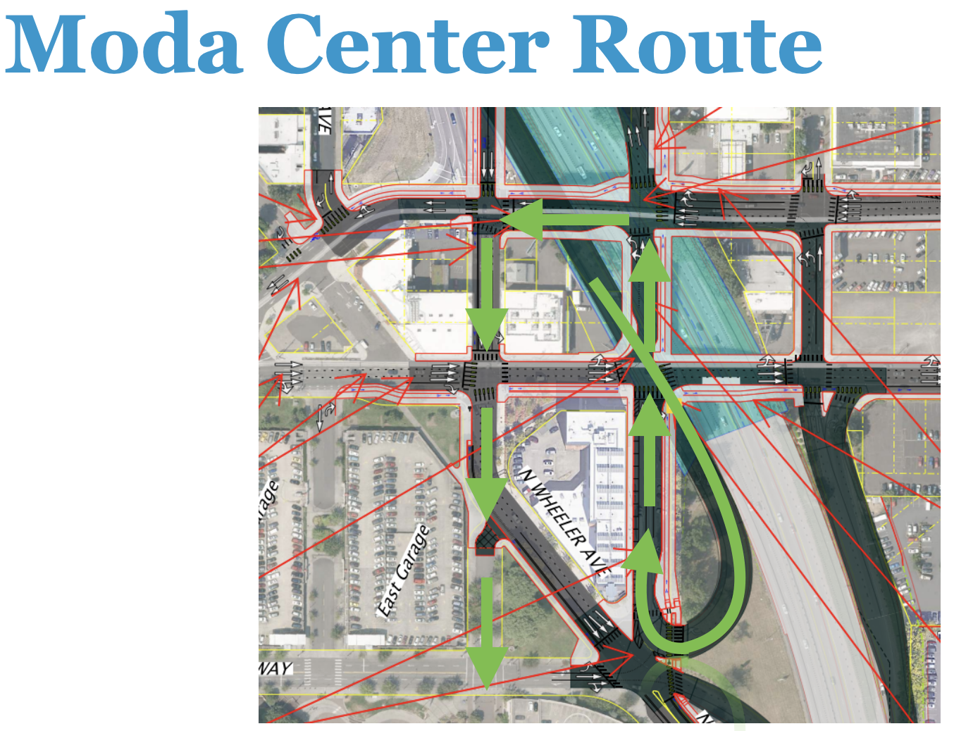
A convoluted route to the Moda Center
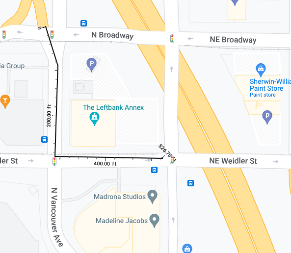
Many Portland residents visit the Rose Quarter to attend concerts and sporting events. Many of them will have to travel much further, and cope with much more local traffic as a result of the ramp re-orientation. The new ramp configuration creates a very convoluted route for traffic traveling from I-5 south to the facilities parking garages. From I-5 South, vehicles have to travel north on Williams, then west on Broadway and then south of Vancouver, traveling a distance of almost half a mile and traveling through five intersections to reach the parking garages.
Computing added travel distances
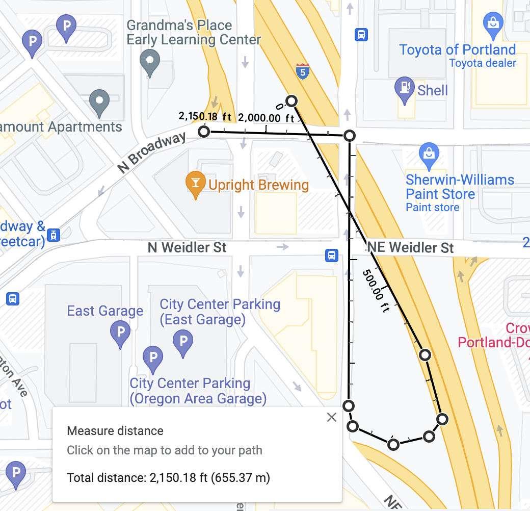
North and East Bound Added Travel Distance: 1,000 feet per trip (net). Vehicles exiting I-5 and proceed eastbound on NE Weidler must travel an 1,500 feet to reach the intersection of NE Weidler and N.Williams,. Similarly, vehicles traveling northbound on Williams must also travel an additional 1,500 feet to reach this same intersection. These vehicles save approximately 500 feet of travel that would otherwise occur traveling south on N. Vancouver and East on N. Weidler to reach this same intersection. The net additional distance per northbound and eastbound trip is 1,000 feet (1,500 feet via the proposed new ramp location compared to 500 feet for the existing ramp location).
Distances for northbound- and East Bound Trips (New Ramp): 1,500 feet
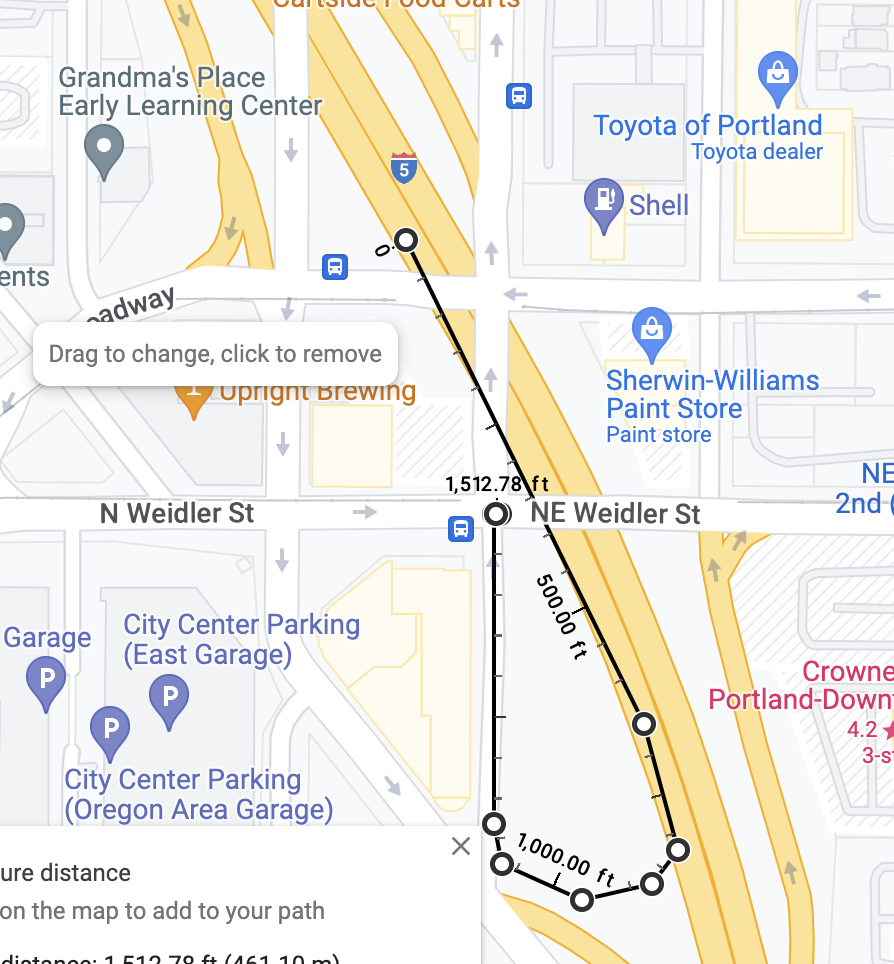
Distance saved by northbound and eastbound trips (500 feet)
Westbound and southbound added trip distance: 2,000 feet. Vehicles exiting I-5 and proceed westbound on N. Broadway must travel an 2000 feet to reach the intersection of N .Broadway and N. Vancouver,. Similarly, vehicles traveling southbound on Vancouver must also travel an additional 1,500 feet to reach this same intersection. All of this distance is in addition to the distance that those same movements would require at the existing intersection location. (Note that because all traffic exiting I-5 southbound must travel north on Williams; there is no option to directly continue southbound on NE Wheeler, because that movement is blocked by traffic traveling onto the southbound I-5 on-ramp, immediately adjacent to the new relocated off-ramp).
A