Interstate 5 “Meat Axe” slashed through the Albina Neighborhood in 1962
This was the second of three acts by ODOT that destroyed housing and isolated Albina
Building the I-5 freeway led to the demolition of housing well-outside the freeway right of way, and flooded the neighborhood with car traffic, ending its residential character and turning into an auto-oriented landscape of parking lots, gas stations and car dealerships.
New York City’s Robert Moses is cast—accurately—as the villain who routinely rammed freeways through city neighborhoods. Freeways, Moses said “. . . must go right through cities, and not around them, . . . When you’re operating in an overbuilt metropolis you have to hack your way with a meat axe.” (Moses, 1954, quoted in Mohl, 2002).
And Moses, the subject of Robert Caro’s epic biography The Power Broker, actually wielded his meat axe in Portland. The original route of the Interstate 5, which at the time was called the “Eastbank Freeway” was recommended by none other than Moses, who came to the city in 1943 with a group of his “Moses Men,” to recommend a public works program for the region, which recommended the city be carved up by a series of freeways.
As part of its efforts to sell a $800 million I-5 freeway widening project in Portland, ODOT, the Oregon Department of Transportation, has made quite a show of acknowledging its complicity in destroying the Albina neighborhood, which six decades ago, was the segregated home of a plurality of the city’s Black residents. But its role didn’t start with the construction of I-5 in the early sixties, nor did it end then. ODOT has made repeatedly hemmed in and destroyed Albina, starting more than seventy years ago.
In part I of this series, we unearthed the largely forgotten—and entirely unacknowledged—role the Oregon Department of Transportation played in triggering the downfall of Portland’s Albina neighborhood in 1951, with its decision to build a mile-long extension of Highway 99W (Interstate Avenue) along the Willamette River. Of all the public “investments” that dismantled Albina, this was the first, but not the last.
1962: ODOT’s I-5 cuts through Albina
Less than a decade later, the Oregon State Highway Department was back, with another apply another meat axe to the Albina neighborhood, in the form of the construction of Interstate 5. It chose a route for the new Interstate 5, largely parallel to and less than a mile east, cutting through the heart of the Albina neighborhood. And in true 1960’s freeway fashion, the right of way wasn’t just a narrow slice of land, the highway department condemned and demolished businesses and housing for several blocks on either side of the land eventually used for the roadway.
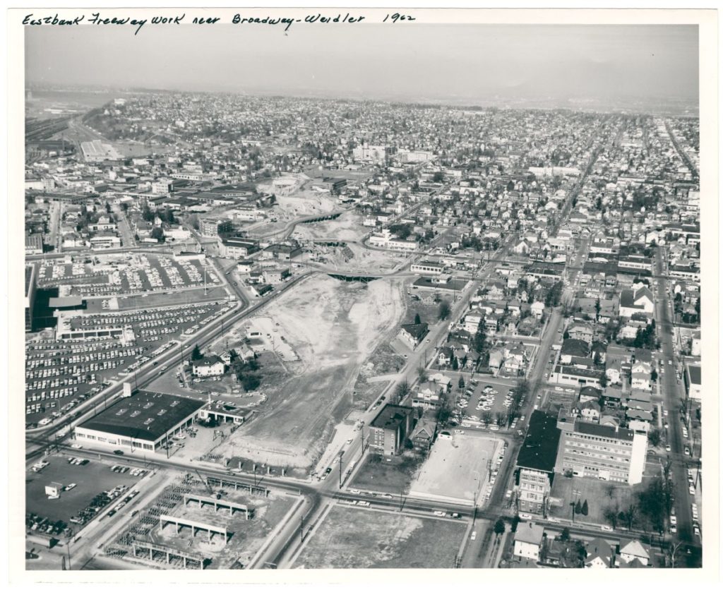
That’s apparent in this 1962 photo showing the project’s construction:
In its effort to sell a new $800 million widening of the I-5 freeway through what’s now called the Rose Quarter (to build, as we’ve shown a ten lane freeway), ODOT has made a conspicuous show of apologizing for the original construction of the freeway. But in our view, the apology has been glossed over ODOT’s role. Their public relations materials have dramatically understated damage done to the neighborhood.
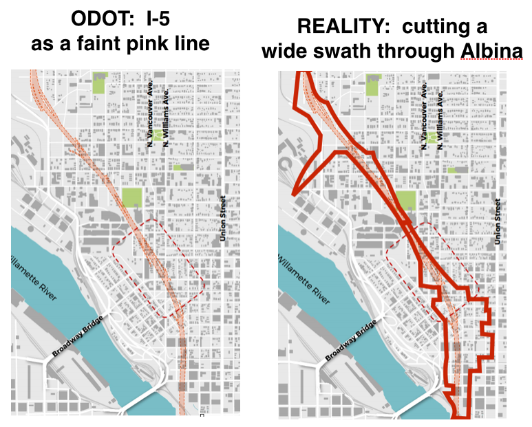
Here’s a diagram prepared by ODOT consultants, to show how the freeway affected the Albina neighborhoods as it appeared in 1954 (i.e. after ODOT had already built Highway 99W). ODOT’s historical map shows the homes and businesses as they existed in 1954, and then overlays the I-5 freeway itself as a pair of slender pink lines. But this significantly understates the scale of the demolition in Albina. The freeway’s true footprint involved acquiring and demolishing property on both sides of the roadway, as shown in the solid red lines on the right. Critically, I-5 disconnected much of the Albina street grid.
The area outlined in red on the right hand side of this diagram shows blocks where multiple structures that existed in 1948 had been demolished by 1962, as shown in aerial photographs (see below). This includes both the land occupied by the freeway itself, as well as land cleared as part of the construction process.
The I-5 Freeway Construction Footprint
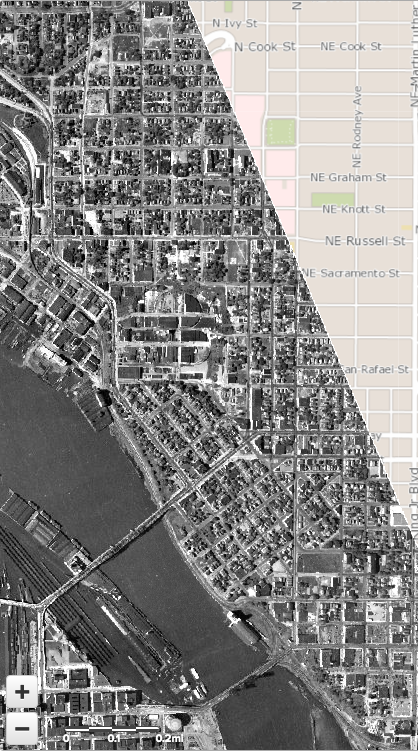
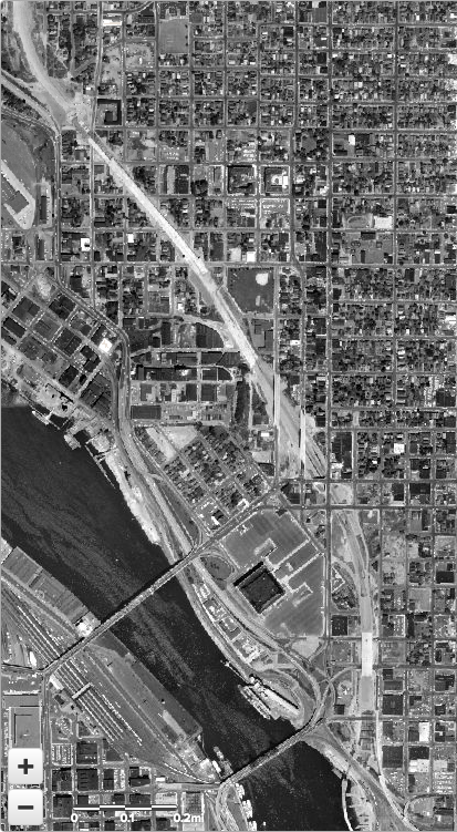
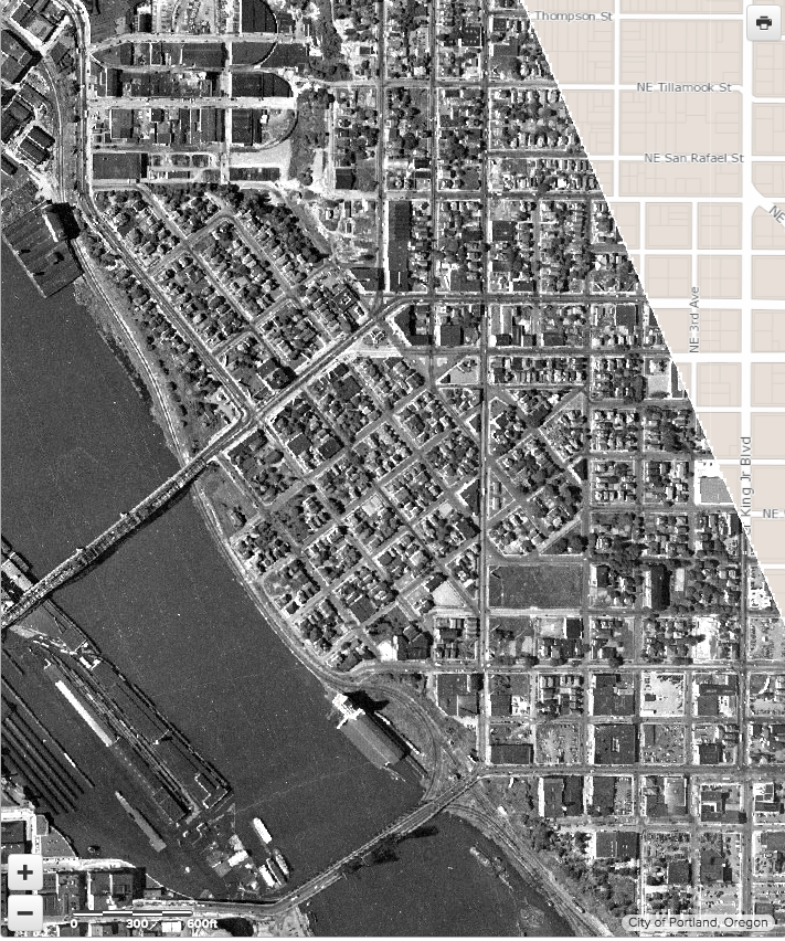
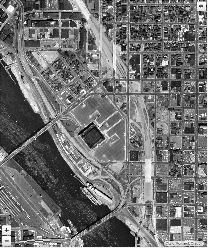
To get a closer look at this reality, compare these pairs of aerial photographs taken before and after I-5 construction. The reality is the I-5 freeway leveled whole city blocks on either side of the right of way. This pair of images allows you to see a “before” and “after” view of the neighborhood. The before image from 1948 shows the housing and businesses that existed prior to freeway construction; the after shows what was demolished by 1962. We haven’t been able to obtain data showing a complete list of the properties ODOT acquired and demolished, so we’ve relied on photo interpretation to identify blocks where housing or buildings that existed in 1948 had been demolished in 1962. It may be that some privately owned homes adjacent to the freeway were abandoned by their owners and demolished.
Albina: From the Steel Bridge to N. Cook Street
Our first pair of aerial photographs shows the entirety of Albina from the Steel Bridge on the South to N. Cook Street (just near the Boise-Eliot School) on the North. (The original 1948 photograph is truncated on the East)
[compare]
[/compare]
1948 ↔ 1962
Close Up: The southern part of Albina
The damage done by the construction of the I-5 freeway is even more apparent when we zoom in to the southern portion of the neighborhood, the area between the Broadway and Steel bridges, and between the Willamette River and Martin Luther King Boulevard (called Union Avenue in 1962).
1948 ↔ 1962
Freeway traffic, not just the roadway, is what doomed Albina
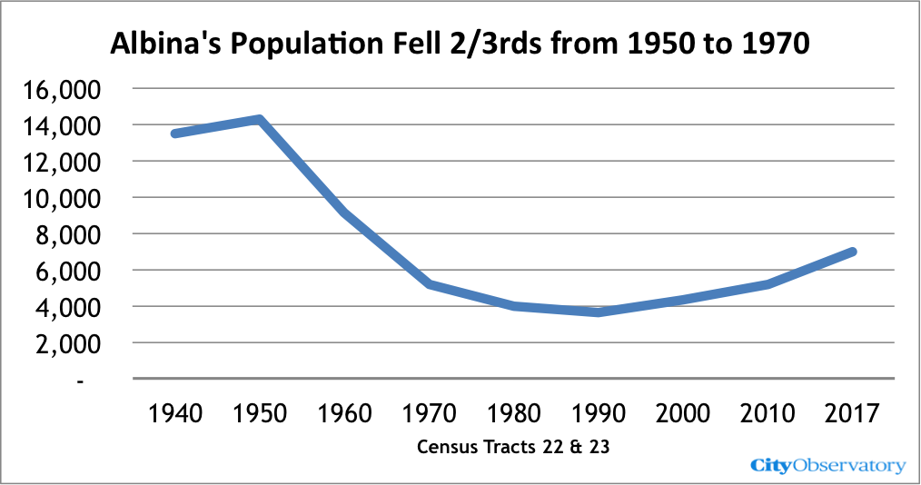
The result of ODOT’s highway construction was to obliterate much of Albina, and to isolate the remaining parts of the neighborhood. Predictably, the neighborhood’s population collapsed between 1950 and 1970, as the area was given over to the automobile. Much of the decline in population in Albina happened years after the freeway was built. The flood of cars undercut neighborhood livability, and population steadily declined in the 60s, 70s and 80s. As people moved away, neighborhood businesses that served local residents, many owned by African-Americans, died. More cars, fewer people, fewer businesses, and a shrunken impoverished neighborhood Building the freeway clearly privileged the interests of those driving through the area, especially suburban commuters, over the people who actually lived here.
The construction of I-5 was the second act in a three-part tragedy that doomed the Albina neighborhood. The first was the construction of Highway 99W in 1951, cutting the neighborhood off from the River. The I-5 freeway construction in 1962 demolished a huge share of the neighborhoods housing, and irrevocably turned this residential area into an auto-dominated sea of parking lots, roadways, gas stations and car dealerships. But as we’ll see, there was a third act in the early 1970s that largely completed the encirclement and destruction of the neighborhood by ODOT highways.
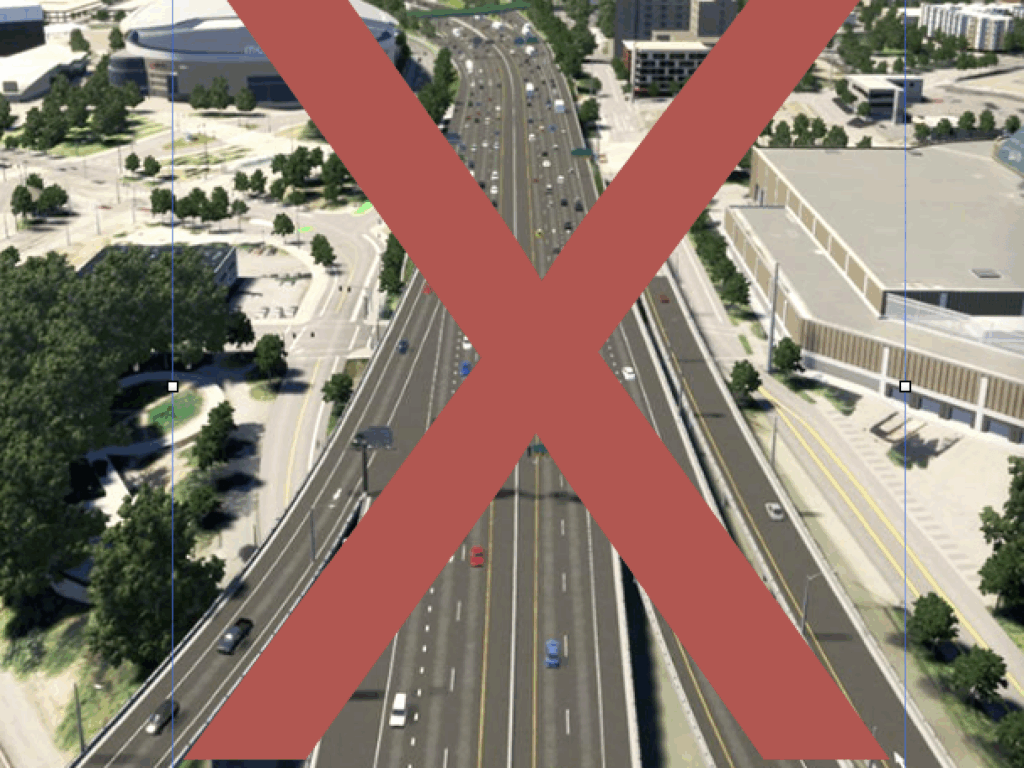
It’s sometimes said that what’s past is prologue. The ODOT public relations campaign for the $800 million Rose Quarter I-5 freeway widening project aims to portray it as a mere minor tweak to the existing roadway, the addition of a couple of inconsequential “auxiliary lanes.” They’re implying that if the footprint of the freeway isn’t expanded much there are no impacts. Not only is that not true—the hidden plan is to build a 10-lane freeway through—the Rose Quarter, but the real impacts are driven by the flood of cars this would enable. The real problem with the Rose Quarter freeway is not so much that the project increases the freeway’s footprint—which it does, in ways that ODOT has actively concealed—but rather that by adding additional road capacity, the I-5 Rose Quarter freeway widening project repeats the damage to the neighborhood by injecting even more vehicles into this car-dominated environment. If we learn anything from history, this is not an error that we should allow to be repeated.

