ODOT’s Fremont Bridge wiped out multiple blocks of the Albina neighborhood
A freeway you’ve never heard of leveled dozens of blocks in North and Northeast Portland
The stub of a proposed “Prescott Freeway” still scars the neighborhood
This is the third of a three-part series looking at how ODOT freeways wiped out much of the Albina neighborhood in a little over two decades. Part I showed how the Oregon State Highway Department cut the neighborhood off from the Willamette River in 1951 by the construction of Highway 99W (Interstate Avenue). Part 2 looked at the construction of Interstate 5 in the early 1960s, which slashed through the middle of Albina. Today, in Part 3, we show how an unfinished freeway dealt a third major blow to the neighborhood in the early 1970s.
Portland’s unfinished Prescott Freeway
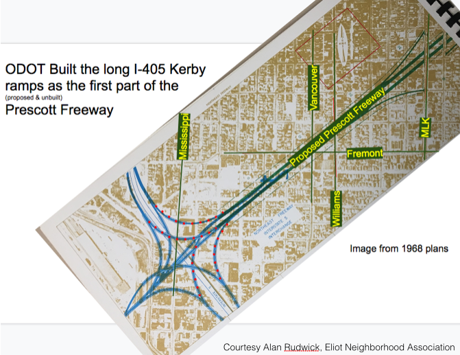
Back in the 1960s, Portland, like many cities had grandiose plans for freeways everywhere. Portland’s plan, called PVMTS (the Portland Vancouver Metropolitan Transportation Study) called for the city to be carved up by a grid of freeways every few miles. One of those freeways was the so-called Prescott or Rose City Freeway, running from Swan Island to 82nd Avenue. Even though it was never completed, this ODOT roadway had (and continues to have) a devastating effect on the Albina neighborhood.
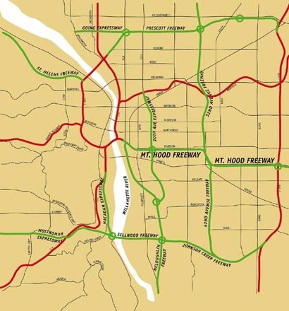
The Prescott Freeway (shown top center in the map above) was designed to connect I-5 and I-205. the freeway would have cut diagonally from the Fremont Bridge, across North Portland, and East to (an unbuilt) 52nd Avenue Freeway and then to I-205 near Portland Airport. As the plan below shows, the segment in North Portland’s Albina neighborhood would have connected to Interstate 5 at a massive cloverleaf intersection at the East end of the Fremont Bridge.
Plans for the Prescott Freeway weren’t abandoned until work on the Fremont Bridge and its approaches were well underway. The Oregon Department of Transportation built about a third of a mile of expressway at the East end of the bridge, but with no freeway to connect to, the expressway was simply truncated to connect to NE Kerby Street.
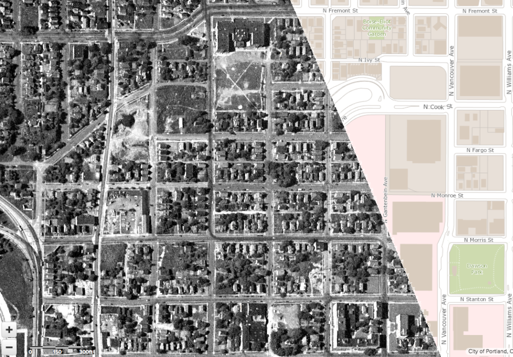
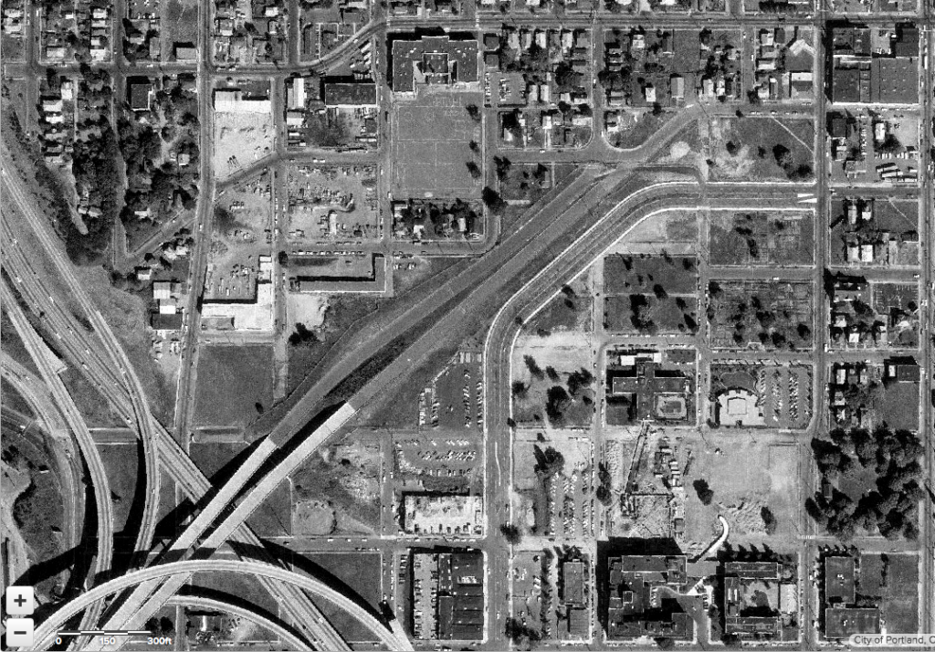
Because the Prescott Freeway angled diagonally across the neighborhood, it tore apart the pre-existing street grid. These two overlaid photographs show the neighborhood as it appeared in 1948 (a nearly continuous street grid, filled with homes and businesses) replaced by a newly constructed freeway in 1975 (with much of the housing demolished and the street grid broken). You can move the slider left and right across the photo to see how the neighborhood looked before and after freeway construction.
[/compare]
The effect of freeway construction wasn’t confined just to the area paved for traffic. Because the intersection was designed for a full set of ramps connecting all the freeways (I-5, I-405 and Prescott), several blocks on either side of the roadway were acquired or demolished. Local streets were truncated and North Kerby Avenue was re-routed into a wide new boulevard, ultimately forming the border for the Emanuel Hospital campus, which expanded onto blocks leveled near the freeway.
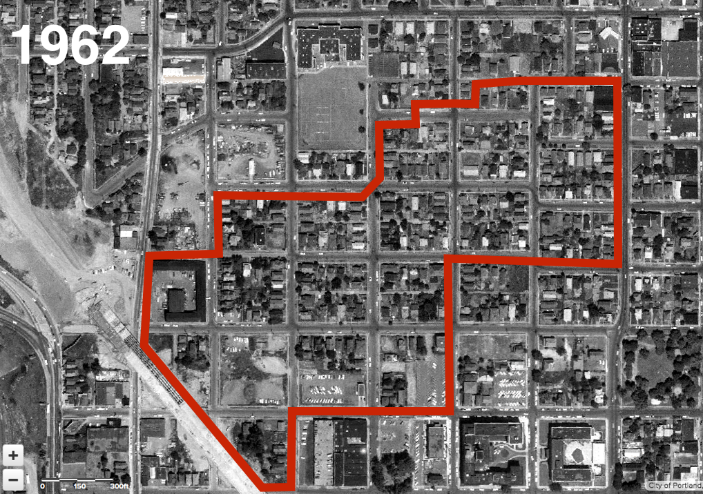
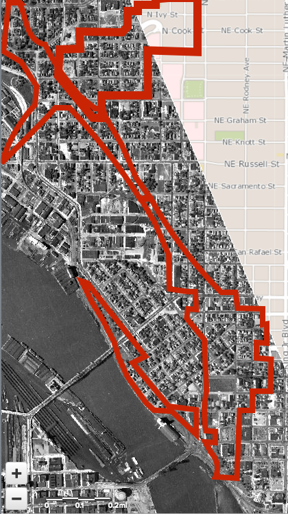
The following map shows the area altered in the wake of freeway construction around what is now the Kerby Avenue off ramp from the Fremont Bridge. This 1962 image shows the ongoing construction of I-5 at the left hand side of the photo. The area taken or demolished at the time of the Fremont bridge ramp construction in the early 1970s is bounded in red.
As the photographic evidence makes clear, this part of the Albina neighborhood had a well-connected street grid, and hundreds of intact houses, at least until ODOT’s freeway construction efforts played out.
A Tragedy in 3 Acts: ODOT highways decimated Albina
Over the course of a little more than two decades, the Oregon Department of Transportation’s highway building wiped out much of Albina. Adding together the land taken by the Highway 99W construction in 1951, the building of I-5 in the early 1960s, and finally the Fremont Bridge and stillborn Prescott Freeway in the 1970s, ODOT’s road-building left a huge scar on the Albina neighborhood. The following aerial photo shows the neighborhood in as it existing in 1948; the areas bordered in red show blocks where housing and businesses were demolished when each of these three highways were built.
The effects weren’t confined to just the buildings knocked down for the roadway itself. Construction efforts directly acquired and demolished a considerable amount of adjacent property (some of which was never used as freeway plans were abandoned). The wholesale demolition of housing deprived the neighborhood of critical mass to support local businesses and schools, population declined by two-thirds in Albina, and property values plunged. Much of the neighborhood’s former housing was given over to surface parking lots. The freeways eviscerated the local street grid, dividing the neighborhood into isolated pockets of remaining housing, in an area increasingly given over to a handful of large institutional uses (an arena, a hospital, a school headquarters), and dominated by large flows of car traffic, mostly from outside the neighborhood. ODOT’s highways were pivotal in the devastation of Albina neighborhood.

