What City Observatory did this week
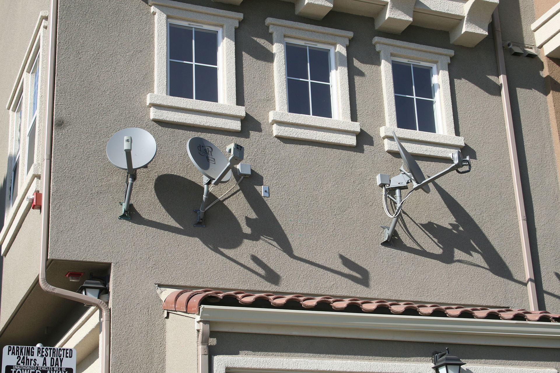
1. Why don’t we have a powerful federal agency who can pre-empt local laws that drive up housing costs? Last week, the Federal Communications Commission took action that invalidated a City Of Philadelphia ordinance that would have regulated the location of satellite antennas and required their removal once they were no longer used. The FCC ruled that Philadelphia’s ordinance might drive up costs and reduce access for TV subscriptions. That got us thinking: Why don’t we have a similarly powerful federal agency that could take a critical look at local land use requirements that drive up housing costs, and restrict access to housing? Apparently, it’s because our nation puts a higher priority on watching television than on housing people.
2. No exit from housing hell. Post-mortems of the defeat of California’s Senate Bill 827 (a measure that would have preemptively legalized apartments in areas with good transit service), highlight a schism between the economics and politics of upzoning. While YIMBYs, economists and a wide range of urbanists support the measure, it foundered, both from the predictable opposition of cities and some homeowners, but also because of a lack of trust among the measure’s intended beneficiaires: low income renters. In many respects, its because these groups cling to the highly transactional view of the land use planning process, implicitly acting as if low income communities can achieve equity only if they can be just as NIMBY as high income ones.
Must read
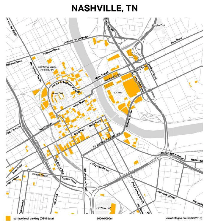
1. Parking craters, writ large. We’ve just finished another of Streetsblog’s annual “Parking Madness” competition, in which readers vote for the city that has the most egregious, life-sapping surface parking lots. (Congrats to Lansing, Michigan for bringing home the Golden Crater). But as we all know, the effects of a parking crater aren’t individual, they’re cumulative; it’s the profusion of surface parking lots that eats away at the fabric of urban vitality. A new set of maps from Reddit user “Afrofagne” shows how surface parking lots dominate parts of of the urban center of each of the nation’s 50 largest metro areas. Using Open Street Maps, they’ve highlighted the size and location of surface parking lots, and by using a common 5 kilometer (roughly 3 mile) square to depict each city, you get a sense of which places are most (and least) dominated by parking craters. By its nature, the maps rely on the completeness of the Open Street Maps database, which isn’t perfect (it appears that data peters out in some peripheral neighborhoods), but this is a useful picture of how parking truly dominates urban space in most cities.
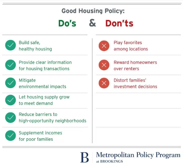
2. Nine rules for better housing policy. The Brookings Institution’s Jenny Schuetz neatly summarizes the principles that should guide all policy-makers–federal, state and local–as they think about how to address housing. She’s boiled her arguments down to a series of do’s and don’ts, all of which are worth remembering. We especially like items four and five on the “do” list (let housing supply grow to meet demand, and reduce barriers to high-opportunity neighborhoods), and the second don’t “don’t reward homeowner’s over renters.”
3. How grocery stores reduce traffic. Nick Magrino on CityPages has a great story from the Twin Cities. Along with new apartment development in Minneapolis, there’s been a raft of new grocery stores opened in urban neighborhoods–Whole Foods, Target, Trader Joe’s and Aldi–as well as local operators. Magrino makes the point that the profusion of shopping opportunities close at hand means that city residents have shorter shopping trips and the opportunity to more easily bike or walk to the store, rather than to drive. This perspective turns the usual traffic engineering perspective on new commercial uses on its head: building a grocery stores is assumed to generate trips and traffic. It’s a paradox: each individual store can be thought of a generating its traffic, but the more stores there are for a given population, the likelier it is that they’ll be fewer (and shorter) car-based shopping trips.
New Knowledge
Using ‘R’ to get American Community Survey. OK, we’re going to get a bit wonky this week. If you want to take the measure of American cities or neighborhoods, the American Community Survey is your go to source of information. The Census Bureau’s standard American Fact Finder is a user-friendly, if workmanlike way to find your way to just the data you need. But if you’re doing large scale analysis, it’s a bit clunky and involves a lot of pointy-clicky. The go-to software package for large scale statistical analysis is R, which despite a daunting command-line interface, gives you extremely powerful tools for analyzing data. But how to get ACS data into the R for analysis? Well, as is often the case with great open source products, someone’s built exactly what’s needed. In this case its Texas Christian University professor Kyle Walker who’s created a package called “tidycensus” which automatically extracts ACS data from the Census web server and ports it to an R data-frame for analysis. If you’re a regular user of ACS data, its well worth your time to learn to use this great–and free–tool.
In the news
1. The Sacramento Bee‘s Foon Rhee reported on Joe Cortright’s presentation to Sacramento’s Project Prosper meeting on April 26, including an analysis of Sacramento’s retention of college graduates.
2. The California Office of Planning and Research cited our commentary “Adding highway capacity is not a GHG reduction strategy,” in its CEQA Technical Adivsory on evaluating transportation impacts.
