Has Louisville figured out how to eliminate traffic congestion?
By Joe Cortright
Louisville is in the transportation world spotlight just now. It has formally opened two big new freeway bridges across the Ohio River, and also rebuilt its famous (or infamous) “spaghetti junction” interchange in downtown Louisville. A story at Vox excoriated the decision to rebuild the interchange rather than tear out the riverfront freeway as a “a testament to how cars degrade cities.” In our first story about the Louisville area’s new $3 billion bridge project, we described how a bizarre toll structure will actually encourage wasteful driving, and probably lead to periodic congestion
But there’s another problem with the Louisville bridges: Only half the highway crossings are tolled. The main, north-south I-65 crossing, now encompassing twelve traffic lanes (split between the new Abraham Lincoln Bridge and a renovated Kennedy Bridge) will be tolled as will a new “East End Crossing,” about eight miles to the north. But two other highway bridges, the Sherman Minton bridge carrying I-64 from the West, and the venerable 1920s era Clark Memorial Bridge (usually referred to as the Second Street Bridge) continues to be free.
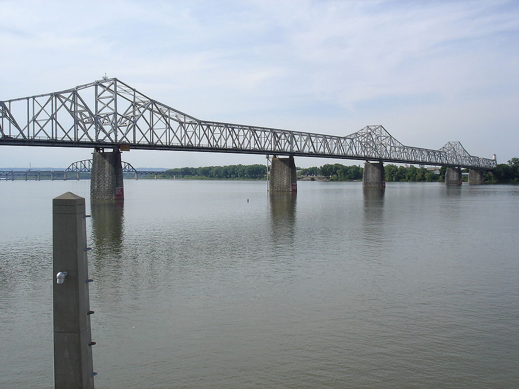
The other tolled route is the East End Bridge new crossing, far from existing routes. But the I-65 crossing–carried on the parallel Kennedy and Lincoln bridges–is just a few hundred feet upriver from the Second Street Bridge. While regular commuters will pay just a dollar a trip to use I-65 (provided they cross it at least forty times a month), occasional users will pay three or four dollars each way if they don’t sign up for a transponder, and instead, rely on toll-operator RiverLink to capture an image of their license plate.
According to Google Maps, taking the Second Street Bridge rather than the I-65 bridge adds about two minutes to a car trip from Jeffersonville Indiana, across the river to Louisville. So the question many motorists will face is: is it worth $3 or $4 to save two minutes on their trip.
The big question here is: How many commuters will take the Second Street Bridge to avoid paying tolls on the new Lincoln and Kennedy I-65 bridges? Of course, it will be months–or longer–before we get the detailed and definitive traffic counts that will enable us to answer that question, but given our curiosity about the results of this economic experiment, we decided to take a quick peak at the traffic cams for the two facilities. This is of course an inexact and unscientific comparison, but the results are interesting.
In Louisville, Kentucky’s Transportation Cabinet operates a website called “TRIMARC“–”Traffic Response and Incident Management Assisting the River City”–which has a network of traffic cameras monitoring the region’s principal arterials and freeways. On January 17, shortly after 5pm we captured images of the traffic on the Second Street Bridge and the Kennedy and Lincoln Bridges from this website. Tuesday, January 17th was an ordinary business day, following Monday’s Martin Luther King Day holiday, and the weather was clear and dry, with temperatures in the mid-50s. Tolls had been in effect on the bridges for almost three weeks–since December 30.
First, here’s an image of traffic just North of the Kennedy and Lincoln I-65 bridges at milepost 0.1 in Indiana. This view is from Camera 3869, looking North toward Indiana, with the Southbound travel lanes (entering Louisville) on the viewer’s left and and the Northbound travel lanes (leaving Louisville) on the viewer’s right. The metal lattice structure stretching across the freeway in the foreground is the gantry holding the bridge’s toll collection cameras and sensors. This picture was taken at 5:07 pm EST.
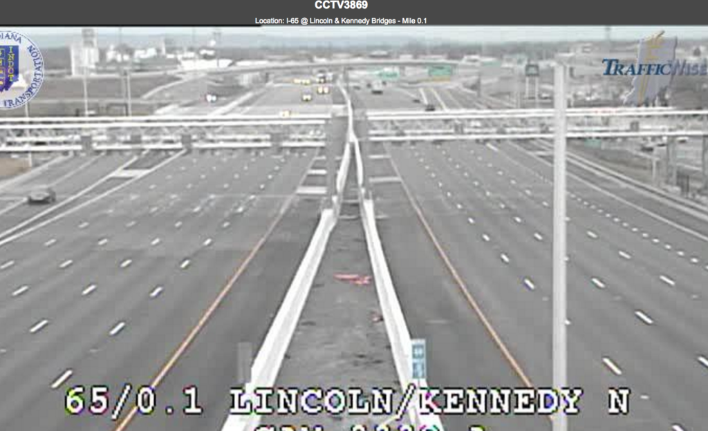
Each of these bridges is striped for five lanes of traffic at this point. As you can see there traffic is extremely light. (For you highway buffs, this is Level of Service “A”).
Next, here’s an image of traffic coming off the Second Avenue Bridge as it enters downtown Louisville. The vehicles on the left are Southbound into the city, the vehicles on the right are Northbound leaving the city. This picture was captured at 5:05 pm EST.
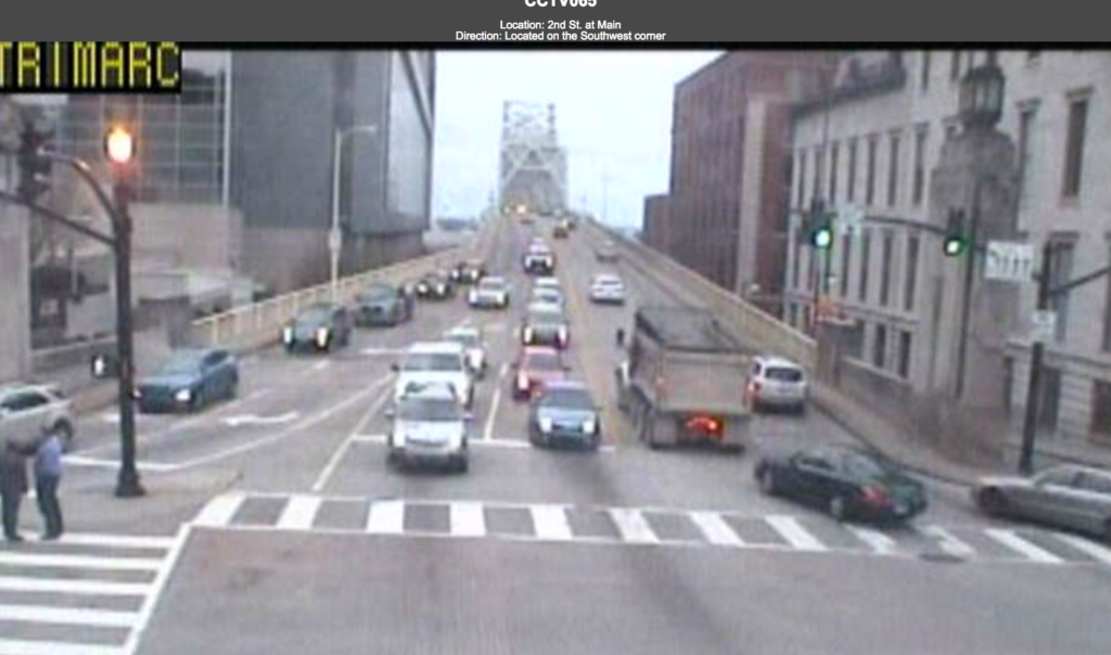
The Second Street Bridge has four travel lanes–two in each direction. As the two Southbound lanes enter downtown Louisville (on the left of this image) they branch into two right turn lanes and two through lanes. Although this camera is set at a much lower height, and therefore shows a shorter segment of roadway than the I-65 camera above, there are clearly more vehicles shown crossing the Second Street Bridge than are crossing the I-65 bridge at nearly the same time. (The truck in the center of the picture is saving $12 compared to the cost of driving over the nearby I-65 bridge).
This very anecdotal, if visual, information suggests a couple of hypotheses. First, it does appear that a fairly large segment of traffic crossing the Ohio River in Louisville on this particular afternoon chose the older, slower and non-tolled route over the newer, faster and more expensive tolled freeway bridges. Second, it seems like there is plenty of capacity crossing the Ohio River at this particular point to accommodate all these vehicles. Not only is the freeway nearly deserted, but traffic appears to be well below capacity on the Second Street Bridge as well.
Of course, this is a small sample and a highly unscientific set of observations. But taken at face value, these pictures call into question the decision to spend several billion dollars to increase highway capacity over the Ohio River. If so few cars are actually crossing the river at peak hour on a typical business day, and if such a relatively large proportion of them apparently prefer to use the older, slower route rather than pay to use the fancy new crossing, did the states of Kentucky and Indiana have any reason to spend so much to build a giant new bridge? And will the two states, who are counting on toll revenues to pay back a major share of the cost of the project, be able to cover their debts?
There may be some very good news here. The image of I-65 is compelling evidence of how to alleviate, if not completely eliminate peak hour traffic congestion: Charge a toll. When faced with a positive price for driving (the toll is $1 each way for regular commuters) apparently very few people want to drive on the freeway. As we’ve long maintained at City Observatory, traffic congestion is a direct consequence of charging too low a price to road users. Kentucky and Indiana have apparently demonstrated that a very modest level of tolling can work wonders for alleviating traffic congestion. It’s just too bad that they also had to spend several billion dollars for highway capacity that motorists apparently don’t want in order to find that out.
Has Louisville figured out how to eliminate traffic congestion?
Louisville is in the transportation world spotlight just now. It has formally opened two big new freeway bridges across the Ohio River, and also rebuilt its famous (or infamous) “spaghetti junction” interchange in downtown Louisville. A story at Vox excoriated the decision to rebuild the interchange rather than tear out the riverfront freeway as a “a testament to how cars degrade cities.” In our first story about the Louisville area’s new $3 billion bridge project, we described how a bizarre toll structure will actually encourage wasteful driving, and probably lead to periodic congestion
But there’s another problem with the Louisville bridges: Only half the highway crossings are tolled. The main, north-south I-65 crossing, now encompassing twelve traffic lanes (split between the new Abraham Lincoln Bridge and a renovated Kennedy Bridge) will be tolled as will a new “East End Crossing,” about eight miles to the north. But two other highway bridges, the Sherman Minton bridge carrying I-64 from the West, and the venerable 1920s era Clark Memorial Bridge (usually referred to as the Second Street Bridge) continues to be free.
The other tolled route is the East End Bridge new crossing, far from existing routes. But the I-65 crossing–carried on the parallel Kennedy and Lincoln bridges–is just a few hundred feet upriver from the Second Street Bridge. While regular commuters will pay just a dollar a trip to use I-65 (provided they cross it at least forty times a month), occasional users will pay three or four dollars each way if they don’t sign up for a transponder, and instead, rely on toll-operator RiverLink to capture an image of their license plate.
According to Google Maps, taking the Second Street Bridge rather than the I-65 bridge adds about two minutes to a car trip from Jeffersonville Indiana, across the river to Louisville. So the question many motorists will face is: is it worth $3 or $4 to save two minutes on their trip.
The big question here is: How many commuters will take the Second Street Bridge to avoid paying tolls on the new Lincoln and Kennedy I-65 bridges? Of course, it will be months–or longer–before we get the detailed and definitive traffic counts that will enable us to answer that question, but given our curiosity about the results of this economic experiment, we decided to take a quick peak at the traffic cams for the two facilities. This is of course an inexact and unscientific comparison, but the results are interesting.
In Louisville, Kentucky’s Transportation Cabinet operates a website called “TRIMARC“–”Traffic Response and Incident Management Assisting the River City”–which has a network of traffic cameras monitoring the region’s principal arterials and freeways. On January 17, shortly after 5pm we captured images of the traffic on the Second Street Bridge and the Kennedy and Lincoln Bridges from this website. Tuesday, January 17th was an ordinary business day, following Monday’s Martin Luther King Day holiday, and the weather was clear and dry, with temperatures in the mid-50s. Tolls had been in effect on the bridges for almost three weeks–since December 30.
First, here’s an image of traffic just North of the Kennedy and Lincoln I-65 bridges at milepost 0.1 in Indiana. This view is from Camera 3869, looking North toward Indiana, with the Southbound travel lanes (entering Louisville) on the viewer’s left and and the Northbound travel lanes (leaving Louisville) on the viewer’s right. The metal lattice structure stretching across the freeway in the foreground is the gantry holding the bridge’s toll collection cameras and sensors. This picture was taken at 5:07 pm EST.
Each of these bridges is striped for five lanes of traffic at this point. As you can see there traffic is extremely light. (For you highway buffs, this is Level of Service “A”).
Next, here’s an image of traffic coming off the Second Avenue Bridge as it enters downtown Louisville. The vehicles on the left are Southbound into the city, the vehicles on the right are Northbound leaving the city. This picture was captured at 5:05 pm EST.
The Second Street Bridge has four travel lanes–two in each direction. As the two Southbound lanes enter downtown Louisville (on the left of this image) they branch into two right turn lanes and two through lanes. Although this camera is set at a much lower height, and therefore shows a shorter segment of roadway than the I-65 camera above, there are clearly more vehicles shown crossing the Second Street Bridge than are crossing the I-65 bridge at nearly the same time. (The truck in the center of the picture is saving $12 compared to the cost of driving over the nearby I-65 bridge).
This very anecdotal, if visual, information suggests a couple of hypotheses. First, it does appear that a fairly large segment of traffic crossing the Ohio River in Louisville on this particular afternoon chose the older, slower and non-tolled route over the newer, faster and more expensive tolled freeway bridges. Second, it seems like there is plenty of capacity crossing the Ohio River at this particular point to accommodate all these vehicles. Not only is the freeway nearly deserted, but traffic appears to be well below capacity on the Second Street Bridge as well.
Of course, this is a small sample and a highly unscientific set of observations. But taken at face value, these pictures call into question the decision to spend several billion dollars to increase highway capacity over the Ohio River. If so few cars are actually crossing the river at peak hour on a typical business day, and if such a relatively large proportion of them apparently prefer to use the older, slower route rather than pay to use the fancy new crossing, did the states of Kentucky and Indiana have any reason to spend so much to build a giant new bridge? And will the two states, who are counting on toll revenues to pay back a major share of the cost of the project, be able to cover their debts?
There may be some very good news here. The image of I-65 is compelling evidence of how to alleviate, if not completely eliminate peak hour traffic congestion: Charge a toll. When faced with a positive price for driving (the toll is $1 each way for regular commuters) apparently very few people want to drive on the freeway. As we’ve long maintained at City Observatory, traffic congestion is a direct consequence of charging too low a price to road users. Kentucky and Indiana have apparently demonstrated that a very modest level of tolling can work wonders for alleviating traffic congestion. It’s just too bad that they also had to spend several billion dollars for highway capacity that motorists apparently don’t want in order to find that out.
Related Commentary