Should your city build a headquarters hotel?

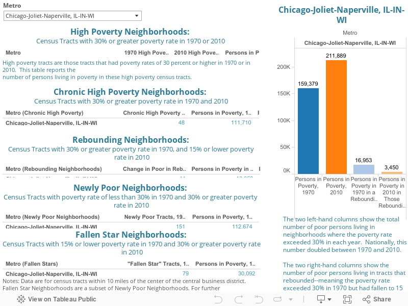
Around the nation, tourism officials are pushing the construction of publicly subsidized “headquarters” hotels to help fill publicly subsidized convention centers. One person who has tracked this industry carefully is University of Texas at San Antonio professor Heywood Sanders, author of the recent book, Convention Center Follies. In this commentary for City Observatory, Woody shares his insights on the lofty expectations and less than optimal outcomes that plague many of these economic development schemes.

by Heywood Sanders

Des Moines wants a convention center hotel. With the argument that its “convention space is not able to live up to its potential due to the lack of an attached hotel,” Des Moines and Polk County officials are seeking a $39 million grant from the state to partially finance a $101 million, 330 room hotel. Des Moines officials are certain that a new hotel will produce a boom in local convention business, based on a consultant study. In Sioux City, they want a convention center hotel too, one with 150 rooms, as part of a planned entertainment and retail district downtown. Armed with a 173-page consultant study, Sioux City wants a piece of the same state grant funds. In Muscatine, city officials are seeking state grant dollars for a 112-room hotel and conference center in the heart of their downtown.

Savannah, Georgia wants a convention center hotel too. They have a consultant study that proves it will bring an increase in convention business. Atlanta wants a really big one, circa 800 to 1,200 rooms. Ft. Lauderdale wants one, and so does Irving, Texas, Pittsburgh, and Portland, Tacoma, and Salt Lake City. With a host of cities around the country, large and small, struggling to fill their convention centers in an overbuilt market, local officials have been told the same tale—in order to compete as a convention destination, in order to make your convention center perform, you need a big “headquarters hotel” next door. As one consultant recently put it, “Convention centers without one need one. Those without enough [hotel rooms] are planning more.”

These cities would join a long list of other communities, from Baltimore and Washington, to Columbus and Cleveland, to Omaha and Denver that have received the same consultant advice and have pursued their own efforts to develop a major new hotel. And when attempts at securing private investment in a convention center hotel have failed, these communities have then gone into the hotel business, financing a new hotel with tax-exempt municipal bonds usually backed by tax revenues. The promise from the expert consultants is that a new hotel will boost the city’s convention business, neatly filling the new hotel rooms and thus a sure bet as a public investment. Then there is the story of Phoenix.

The new, 1,000-room Phoenix Sheraton, financed by the city and backed by a city tax revenue stream, was supposed to be neatly filled by the over 220,000 additional convention attendees brought to Phoenix each year by its $600 million convention center expansion. By 2014, the Sheraton hotel was forecast to hit an occupancy rate of 69 percent, at an average daily rate of just under $200. Things didn’t quite work out that way. Last year the hotel only managed occupancy of 57.5 percent, at a rate of $146.93. Looking at the hotel’s bottom line is even grimmer. The new Sheraton was forecast to generate net revenues in 2014 of over $29 million—more than enough to cover the $22.2 million in debt service. But the hotel actually produced only $11.9 million in net revenues, forcing the city to use more than $12 million in other tax dollars to support the hotel.

Things in Phoenix went wrong for a series of reasons, including the Great Recession. But perhaps the most central (and pervasive) problem for Phoenix lay in a series of overly optimistic consultant studies on the performance of the expanded convention center and adjacent hotel.

A 1999 study by PriceWaterhouseCoopers forecast that a bigger convention venue would boost annual convention attendance by 85 percent, giving Phoenix the ability to host two large conventions at one time. A March 2003 analysis by Ernst & Young promised that the bigger center would see convention attendance grow from the then 125,000 to a forecast 376,861 each year. Hotel consulting firm HVS then took that forecast of 375,000 annual attendees to project 289,282 new hotel room nights in the downtown Phoenix hotel market annually. That new room demand would be more than enough to fill up the proposed 1,000 room Sheraton, and spill over to other downtown hotels.

Unfortunately, things did not work out quite as the consultants had assumed. The expanded Phoenix Convention Center held its grand opening in December 2008, two months after the new Sheraton opened for business. Just two years later, in December 2010, the Moody’s bond rating agency downgraded the hotel bonds. The early portents on the center’s performance had been good, hosting the NBA All-Star Game’s Jam Session in February, followed by the National Rifle Association’s national convention in May. But for fiscal year 2009 (ending June 30), the center managed to attract 284,586 convention attendees—decidedly fewer than 375,000 but a sizable increase nonetheless. It would stand as a high water mark.

The center reported convention attendance of 229,097 in fiscal 2010, and 156,126 the next year. For 2013, the reported attendance was 165,370, with an estimated 173,000 in fiscal 2014. At a cost of $600 million, the expanded Phoenix Convention Center was producing about the same attendance levels Ernst & Young had reported for its predecessor in 1996 and 1997.

Without the boom in convention attendees to fill the Sheraton, the hotel has struggled, with occupancy rates in the 50 percent range since 2010. Even as the impact of the Great Recession has ebbed since 2009, the hotel’s average daily rate has not budged at all, with the 2014 rate of $146.93 still below the $163.90 it managed in its first year.

The Phoenix tale is not unique. A great many publicly-financed hotels, including those in Baltimore, Myrtle Beach, Overland Park, KS, and Omaha have seen faltering performance and downgrades by bond rating agencies. One hotel, the St. Louis Renaissance Grand, failed so spectacularly that it went into default and was ultimately sold for a fraction of its development cost, at substantial loss to the bondholders.

The notion, whether in Des Moines or Pittsburgh or Boston, that a big new hotel is some kind of magic elixir to make a city more successful in the enormously competitive convention business, is based far more on hope than reality. Even with a consultant study.

Urban Employment: How does your city compare?

As chronicled in our report here and commentary here, we are seeing evidence of a shift in employment back to city centers. We believe that this is driven by a number of forces, including the increasing preference of young, talented workers for urban living; some of this shift is cyclical and coincides with the fact that more decentralized industries (construction, warehousing) bore a greater brunt of the pain of the Great Recession. Some of the success has to do with cities gaining competitive advantages over their peripheral counterparts. Regardless of the causes, we are seeing that from 2007-11, aggregate performance of city centers was better than that of their more decentralized peripheries.

Still, there are always outliers– as well as cities that exemplify the trend– so we thought we’d present the following dashboard displaying results for individual metros. It shows the annual growth of employment in the city center (a 3 mile radius from the center of the central business district), as well as in the periphery (defined as the area outside the 3-mile radius).  Data are for two time periods:  2002-07 and 2007-11. Use the dropdown menu to select a metropolitan area.

Our dashboard also allows you to compare, side-by-side, the performance of a selected metro area with the aggregate performance of the 41 metropolitan areas included in our study.  To see this comparative summary, select the right-hand tab at the top of the dashboard.

Best Bar Cities

Great public spaces make great cities. But so do great private spaces. They provide opportunities for people to socialize, and provide the character that make a city more livable and unique. We have already talked about how restaurants add value to a city– but thought we’d look at bars in the same way.

Now, what makes a great bar depends on who you talk to- but regardless of if you prefer a wine bar with small plates, a gastropub, or a dive bar with ski ball (or without ski ball)—bars contribute to a city’s livability and an individual’s experience within a city. Trying to argue that one is better than another is, well, a way to start a barroom brawl. So while we can’t resolve which cities have the best bars, we can at least count which cities have the most bars.

We used County Business Patterns data to analyze the number of bars per 10,000 workers each the top 51 most populous metro areas. (The latest data is from 2012, reflected below):

It’s no surprise that New Orleans comes up first—it is renowned for its bars. (In case it wasn’t on your calendar, Mardis Gras is right around the corner..) There’s no particular rhyme or reason for the rest of the ranking; a variety of things can influence bar culture, such as policy and availability of licenses, availability and strength of public transit, age of residents (younger residents will desire more bars than older ones), and weather (colder places have seen higher consumption rates of alcohol).

Of course, the number of bars per capita isn’t a measure of quality (much like it isn’t for restaurants, either). More bars may reflect loose regulations, a higher city-wide per capita income, and of course, a desire for variety. For example, Pittsburgh’s historical blue-collar workforce may desire its older dive bars, but its new population of young engineers and medical workers allow for hip and more expensive wine, whiskey, and champagne bars to flourish.

Bars are just one way in which a city can make itself more livable for its residents. Livability is important—it attracts residents, and therefore tax payers, and helps to retain younger, talented workers. Ed Glaeser, Harvard economist and author, has encouraged the city of Boston in its efforts to allow bars to stay open later. He sees it as a matter of making Boston “livelier.” A city’s liveliness, to which bars certainly contribute, may not be of the utmost importance to all residents—but it’s clear it’s important to some, and can be a strategic advantage to cities. (To read more about how city distinctiveness and its placemaking efforts can benefit cities, go here and here.)

Happy New Year from City Observatory

15534635544_199daf52aa_z

Those of us at City Observatory wish you all a Happy New Year.

Its been just three months since we launched in October, and its been a busy period for us.  We’ve released two major reports–Young and Restless and Lost in Place.

We’ve been gratified at the reception that this research has received with media coverage in the New York Times, Bloomberg, the Washington Post, Vox, and Time.

But we’re even more excited about the conversations that are proceeding on both these topics at cities around the country. We’ll continue to follow up on both these topics, giving you updated and in-depth research, and exploring the policy options cities have for tackling these challenges.

We’re just getting started.  We expect 2015 to be an even bigger year.  We’ve got several more research projects in the pipeline, starting with a close look at the health and prospects of city center economies–look for it early in the New Year.

We’ll also continue to regularly comment on current issues in cities, and share with you the latest data-driven insights, both from our work and from around the web, on what’s driving city success.

Finally, as the old year draws to a close, we want to acknowledge the strong support we’ve received from the John S. and James L. Knight Foundation in establishing City Observatory .

Wishing you all the best in 2015,


Joe, Patty & Dillon

The City Observatory Team


Photo courtesy of dickdavid and Flickr Creative Commons.

How Poverty Has Deepened (part 2)

Recently, we discussed the growth in the number of urban high-poverty neighborhoods, which we illustrated by examining the distribution of poverty rates among census tracts. This analysis showed that high poverty neighborhoods are becoming more common in urban areas. Today we will use this distribution to discuss what few of us have directly experienced: extremely concentrated poverty. There is a small but growing segment of the population that lives in significantly differently conditions than the rest of the population; this group is one that sees extreme hardship and the highest rates of poverty nationally.

As you can see, while next to no one lived in urban census tracts had an 80% or higher poverty rate in 1970, over 72,000 people lived in neighborhoods with an 80% or higher poverty rate 40 years later. 20,000 lived in tracts with a 90% or higher poverty rate. It is extremely difficult for many to imagine living in a neighborhood where 1 in 2 people live in poverty (notice that this number tripled 1970 to 2010), but to live in a place where almost no one lives on more than $22,050 a year- for a family of 4- has profound implications for those residents.

While 72,000 is not a lot in the scope of the millions of residents of urban neighborhoods nationwide, it is still deeply concerning to have that many live in pockets of such highly concentrated poverty. To understand more about what 80% poverty means, I examined a census tract in Cleveland with an 83% poverty rate. It is census tract # 39035109801, and it is part of the Central neighborhood in Cleveland. In 1970, it had over a 50% poverty rate. Google Earth shows this picture of it:

cleveland google maps

It is a mix of empty land, industrial warehouses, and low-income housing units. The 2010 Census data provides the following demographic breakdown:

These are extremely atypical demographics. For example, the national median household income was $50,046 in 2010, compared to $7,654 in this neighborhood. Even with pictures, numbers, and demographic profiles, it is very difficult for most people to understand how difficult it can be to live in a place with this level of poverty.

We know that high poverty rates– even at the levels of 30% instead of 50% or higher- can have long-lasting implications for residents. Specifically,

“Concentrated poverty is associated with negative social effects (higher crime, worse mental and physical health), and lower economic prospects (both for current residents now and their children over their lifetimes). Concentrated poverty tends to be self-reinforcing: low-income communities have fewer fiscal resources (despite greater needs), producing low-quality public services. A lack of strong social networks undercuts the political efficacy of these citizens. There are a number of studies that review the extensive literature on the negative effects of concentrated poverty (Jargowsky & Swanstrom, 2009; Sard & Rice, 2014; Kneebone, Nadeau, & Berube, 2011).”Lost in Place: Why the persistence and spread of concentrated poverty—not gentrification—is our biggest urban challenge.

Most troubling is the direct impact on children in poverty. 26% of children are living in poverty, almost double the national rate (14.5%). In the neighborhood I just highlighted, 897 children 14 and younger—or 45% of the population according to the census—grew up in a place where if they were not impoverished, almost all of their neighbors were. The effects of a poor neighborhood, including sub-standard public services, worse schools, a lack of social ties necessary to get better jobs, and the many other well-noted direct social and economic impacts of living in concentrated poverty all mean that a growing number young children are growing up with less of a chance than they would have had 40 years ago.

More unfortunately, this also means that demographically, the growing concentration of poverty and income segregation has resulted in lower opportunities for people of color. Poverty and lowered income mobility disproportionately affects children of color; 71% of black infants and toddlers are low income, as are 67% of Hispanic infants and toddlers. (The Central neighborhood above is an even more extreme example of this disproportionality.) New evidence by Reardon, Fox and Townsend (2014) examines economic integration and racial segregation, noting that:

“The racial disparities in neighborhood income distributions are particularly troubling because these are differences that are present even among households with the same incomes. If long-term exposure to neighborhood poverty negatively affects child development, educational success, mental health, and adult earnings (and a growing body of research suggests it does, as noted above), then these large racial disparities in exposure to poverty may have long-term consequences. They mean that black and Hispanic children and families are doubly disadvantaged—both economically and contextually—relative to white and Asian families.

Given the self-reinforcing nature of poverty and its effects, this is a very concerning trend for black and Hispanic communities. The more common experience of urban poverty, and its concentration and deepening, doesn’t add up to a promising future- for any of us.

(At CityObservatory, we will continue to explore themes of poverty, economic integration, and policy solutions aimed at alleviating these issues. We also hope to illuminate growing evidence that increasing the welfare of low-income citizens has positive implications for middle and higher-income citizens. To read more about income segregation and economic opportunity, go here. For some links to articles we find particularly relevant go here and here.)

How Poverty Has Deepened (part 1)

Many talk about poverty—its causes, its effects, and its possible remedies. There is literature on this issue from almost every social science, and no one can summarize it all in one blog post. However, there’s one aspect of our most recent report that I wanted to highlight: the deepening of poverty. Not only are we seeing much more highly concentrated poverty than we used to–but this has the most profound effect on children.

As a quick background if you haven’t read it: the report looks at concentrated poverty in urban neighborhoods (census tracts within 10 miles of the central business district), and concludes that a full three-quarters of neighborhoods that were high-poverty neighborhoods 40 years ago are still mired in poverty today. Additionally, the number of new high poverty neighborhoods has tripled, and the number of poor people in them has doubled, a figure that amounts to 3.2 million people.

smaller infographic

Another way to look at this change is to examine the distribution of poverty rates across both neighborhoods (or census tracts), and population within those neighborhoods. (For those of you that aren’t stats-oriented: a distribution– generally graphically shown as a histogram—gives you an idea of what ‘normal’ looks like, and what kind of variation you would see. The highest point on the histogram is the most common  outcome of any given variable.) The following histograms chart out the poverty rate both in terms of population and census tracts. (So, there were 15 million people in neighborhoods with a 0-5% poverty rate in 1970, 5,000 neighborhoods with a 5-10% poverty rate in 1970, and so on.)


As you can see, the general shape is the same across both time periods, and both peak at the 5-10% poverty rate range. However, there seems to be a spreading of both distributions in 2010. That is, while the majority of urban census tracts were in the 5-10% poverty range, the height of this norm was smaller, and there were more people and neighborhoods in the 10% and over bins. This is an indicator that not only are more people in poverty—and economically segregated into high-poverty neighborhoods—but that the experience of high poverty had become more common. The Equality of Opportunity Project has found that intergenerational income mobility is much lower in places with high levels of income segregation; the growing income segregation that we see over this time period means that millions of Americans will not be able to achieve the American dream.

To see the extent of this shift, we examined the tail end of the distribution—basically, the most impoverished neighborhoods. We will discuss this—and its implications—in a post later this week.

How we build our cities: What’s at stake

Guest Commentary by Carol Coletta

It’s a glorious moment to be in the business of promoting the built environment. I use “built environment” to encompass the way we build our buildings, arrange our neighborhoods and public spaces, and interact with one another in place. We’re all consumers of place as individuals, and we are constantly aware of our surroundings. But there’s something bigger going on:

The evidence is mounting that the built environment is hugely important to the success of cities.

We should start by acknowledging this key fact: 64% of the most mobile people in our society – college-educated 25-34 year olds – say, first, they choose the city they want to live in, then they look for a job.

What this means is that quality of life is now more influential than having a job offer when people are deciding where to live. Livability seems to be the new competitive advantage.

Just to put a point on it: 25-34 college-educated year-olds make up the demographic all cities are fighting over.

Now, the built environment is not the whole of quality of life – for 25-34 year-olds or anybody else. But the built environment is a substantial part of how people value cities today.

Let me give you three powerful examples.

First: The growing strength of the center city. You can see evidence of it in cities everywhere.

Over the past four decades, there has been a steady increase in the relative preference of young adults (ages 25 to 34) for close-in neighborhoods – that’s the central business district in metropolitan areas and the 3-mile radius around it. In fact, college-educated young adults today are more than twice as likely to live in these close-in neighborhoods than are other Americans.

This is a 40-year trend that just keeps accelerating.

85% of millennials say they prefer urban-style living, and the numbers prove that they are acting on their preferences.

What is it about the built environment that makes the core city newly valuable to millennials? You know the profile: this part of the city is typically dense, walkable, bikeable, mixed use, mixed age, mixed-type building stock. These are the kinds of neighborhoods we forgot how to build for the past 50 years. Then all of a sudden, we woke up to a back to the future moment.

Now, jobs are following millennials (and increasingly boomers) to core cities. Companies like Google, Biogen, Coca Cola and Visa are moving their offices downtown to tap into the growing talent pool living in cities. It’s happening even in struggling cities like Detroit—where Quicken Loans is explicitly working to promote downtown revitalization.

It’s also true that since the recession, housing prices in America’s most walkable neighborhoods – the ones with higher WalkScores that have more daily destinations nearby — have recovered far more quickly than housing in neighborhoods where you have to drive to get to everything.

See the pattern here? These are no longer anecdotes. This is happening in cities all over the U.S.

The right built environment attracts and keeps mobile talent. The right built environment attracts jobs. And the right built environment adds real estate value.

But there are other ways the built environment Increases the value of cites.

Think about most neighborhoods in your community. They are probably like neighborhoods in Miami or in my hometown of Memphis. The rich live in enclaves, and poor people live in a different part of town. That’s the pattern in cities all over the U.S.

But new research is showing us how deadly that approach is to opportunity… specifically the opportunity to improve your economic status. It turns out that growing up poor in an economically segregated neighborhood significantly lowers the chance that you will improve your financial circumstances.

If zip code is destiny, then the American Dream is dead.

Having people of different incomes living in close proximity to one another and, in effect, sharing their lives in public as people in a community naturally do, results in far more upward mobility for people than does growing up in an economically segregated neighborhood.

Having a civic commons – libraries, parks, rec centers, and the like — that welcomes and delights people of different incomes augments and accelerates the advantages of economic integration. (This is not easy, by the way.)

Consider this: America is becoming ever more bifurcated by income – the rich are getting richer and there is more difference in the incomes earned by those with more and less education. People with less money and less education are getting stuck in place.

If the right built environment can help tackle that problem –delivering even a modicum of progress by bringing rich and poor people into closer physical proximity — that is significant, because today, we are going in the opposite direction.

The right built environment delivers more opportunity to Americans. That’s the second big value-add to cities.

There’s one more piece to the puzzle. The right built environment delivers the kind of engagement that actually moves cities forward.

You may know that Knight Foundation is built on the premise that informed and engaged communities are essential to strong democracies. And the sad fact about engagement is that we’re not doing a very good job of it in most of our communities.

How many of you have been to a public meeting lately?

How many of you enjoyed it? (Count the masochists.)

How many of you think it was a productive discussion about the future of your community?

Clearly, something is wrong here. I’ve run public meetings. I’ve participated in public meetings. I am on a public board that has publicly commented – twice – in each meeting. And it is mind numbing, right? There must be a better way.

Well, a few weeks ago, that better way revealed itself in a most unexpected way. I was interviewing the founders of modern day Portland – the people who became mayors, aides to mayors, state legislators, transit officials, and architects who led important citizen initiatives. They kept using the terms “civic involvement” and “citizen engagement”, and finally I stopped the conversation and asked, what do you mean specifically? What did that look like in Portland?

Their answer stopped me cold.

Here’s what they told me: “For too long, decisions about the future of Portland were made by a few people in the basement of a downtown hotel. We decided that we had to lure people out of the comfort of their living rooms and into public life so that they would engage in an ongoing conversation about the future of their city.”

That was their aim: Get Portlanders to live life in public.

To support that, they began changing policies to allow sidewalk cafes, music in parks, music in taverns, stop the building of expressways through neighborhoods… and you can see the result of that today in Portland: vibrant, compact neighborhoods demarcated by relatively narrow, slow through-streets filled with small commercial enterprises mixed with mid-rise housing.

It is so different from what you see in most American cities, and it all resulted from a desire to get and keep citizens engaged – continuously — in shaping the future of their city.

As the Portland experience shows, citizen engagement is not an event. It is not a process run by consultants. It’s a culture. It’s a constant. It is, crucially, an ongoing conversation about the future of the city. And the built environment, as Portland shows, either supports that kind of ongoing conversation by encouraging people to live life in public, or it discourages it. In fact, in too many places, the built environment actually makes such a conversation impossible.

So why are we surprised when the pitiful processes we create for “engagement” don’t work?

The good news is that we are building smarter and better today than we have in 50 years. The bad news is that we still get it wrong too often. When you get the built environment wrong, you have to live with your mistakes for a very long time.

So growing an engaged citizenry that understands what good design is, why it matters, and will advocate for it forcefully is urgent if we want our cities to be successful. We can’t win this one battle at a time. We can’t treat advocacy for good design as an event. We have to make it part of the culture – the “way we do things around here.” – the rule, not the exception… what we expect for our community.


Carol Coletta is Vice President and leads Community and National Initiatives for Knight Foundation.  You can follow her at @ccoletta.

Is your city or neighborhood poorer than 40 years ago?

We recently released our latest report, Lost in Place: Why the persistence and spread of concentrated poverty–not gentrification–is our biggest urban challenge. It speaks to a national trend that’s been largely ignored– that urban poor are being concentrated into poorer neighborhoods, and that those neighborhoods are increasing in number. We speak here about some of those implications, and here and here we provide references to what others are saying about gentrification and poverty; here we address economic segregation.

Neighborhood change is by definition a highly local process, and everyone wants to know how their city is performing:  What about their city? Their neighborhood?  Nationally, the number of high-poverty neighborhoods tripled, and the number of people in poverty in those neighborhoods have doubled, but this is not the pattern in every city. In Detroit, the numbers are even more staggering–the population living in poverty is more than 228,000, from less than 40,000 40 years previous.  A few places like Virginia Beach saw an actual decline in concentrated poverty.  Rebounding neighborhoods have been more common in some metros like New York and Chicago.

If you want to see the data for individual metros, we’ve created a city-specific dashboard. Just select the city of interest, and you’ll see a comprehensive set of indicators showing how your metro performed between 1970 and 2010.

As you look at individual cities, keep these overall trends in mind:

  • Most cities only had 1 or 2 “rebounding” neighborhoods, or neighborhoods that were previously high poverty, and by 2010 were below the national average rate of poverty (15%).
  • Nationally, the number of high-poverty tracts tripled.
  • Overall, the number of poor people in those high-poverty tracts doubled.
  • High-poverty neighborhoods that didn’t rebound weren’t stable: they lost, on average, 40 percent of their population over 40 years (both of poor and non-poor persons). This means most “chronic high poverty” neighborhoods saw a dramatic reduction in population by 2010.
  • The majority of the increase in those living in high poverty were in newly poor or “fallen star” neighborhoods. (Fallen stars are neighborhoods that had poverty rates below the national average in 1970, but have poverty rates of 30 percent or higher today).  The number of fallen stars exceeded the number of rebounding neighborhoods 12 to 1.

The process of neighborhood change is often difficult and disruptive, and poverty and gentrification are sensitive topics. Each city is different and has unique challenges; however, most cities follow the national trend of increasing concentrated poverty.  If we are serious about bettering the lives of the poor (and we should be), we need to carefully examine the data about change and look for solutions that are fully grounded in the facts of neighborhood change.

If you want to look at each city’s specific tract-level data, go to the report here and scroll to the maps. We will also be sharing an informational post about how these were made soon- check back in a couple days!


How distinct is your city?

Every city has its own unique characteristics. We know that industrial and occupational specializations can be measured using standard economic tools like location quotients. But some of the more intangible characteristics of cities are harder to measure. We’re always on the look out for new and interesting ways of discerning city distinctiveness. The Internet search engine Google provides one window into the way people think about cities.

Unless you’ve been using AOL out of spite, you’ve at least seen Google’s auto fill capability. As you start typing your query, Google tries to guess what you are searching for drawing on its database of the most common search queries.

Some have used this capability as a way to create a natural experiment on human perceptions. Renee diResta hit on the idea of using the Google auto fill function to tease out stereotypes of states. She Googled a state name, and let Google suggest answers, asking for example “Why is [California] so…?”. She noted which words Google suggested and tabulated the results for states. Nate Shivar then took up the mantle, looking at cities instead of states.

We thought this was extremely interesting– if unscientific — and could illustrate how different cities are perceived. Here are Nate Shivar’s results for 50 cities, which we’ve sorted according to the most commonly searched terms. The most Googled term was “expensive” (14 of 50 cities) followed by boring, dangerous, ghetto, and bad. Some search terms were idiosyncratic to a single city, such as “Why does Salt Lake City have such wide streets?” Some places, like Raleigh or Indianapolis registered only one or two descriptors; perhaps they don’t trigger any distinctive characterizations There were some that were clearly not about the city, like Why is Charlotte so uneasy about being on a ship? (Readers of The True Confessions of Charlotte Doyle will know why).

We built the following map to illustrate the geographic patterns of the most common city descriptors. In order to see where apparently the most “ghetto,” polluted or boring places are, all you have to do is click the drop down below for the description of your choice, and select “Y.” (As a side note, if you choose “N” for no, the map will show all of the places that Google users don’t describe as boring, bad, etc. To reset the map, just choose “All” for whatever descriptions you have selected.) To see what the top 4 descriptions are for each city, hover your mouse over the location.

Some of the more interesting observations are:

  • Apparently, Google searchers don’t worry about cities in the Western half of the country as being “bad” or “dangerous.”
  • Many Northern cities you expect to be cold are listed as such, but places like Atlanta and San Diego are seen –by the Google masses– as cold, too. (We didn’t add hot into the map, because there weren’t any surprises there.)
  • Either people simply expected their east coast (…and Midwest … and southern..) cities to be polluted, or one pocket in the West/Southwest — the cities Los Angeles, Denver, Phoenix and Salt Lake City– has particularly bad pollution problems. (While this may be true, big industrial cities like Pittsburgh don’t have people asking why they’re polluted, so we think some of this may be the surprise associated with a city like Denver being polluted.)
  • Concerns about racism are most frequently expressed in three cities: Boston, Philadelphia, and Cincinnati. Interestingly, none of these cities is among the most racially segregated, a group that is led by Detroit, Milwaukee and New York (detailed list is here)
  • With the exception of Minneapolis, if you want live cheaply, don’t live on a coast.
  • The more unusual descriptions follow: Jacksonville is smoky; Portland is white; Detroit is black; Tampa Bay is trashy; Philadelphia is either bad or great; Providence/Rhode Island is corrupt; and, apparently, Google often confuses Columbus — the city in Ohio — with the 15th century explorer.

Thanks very much to Nate Shivar investigating auto fill for cities. Based on his later revisions, like Providence and Rhode Island as a whole are synonymous to many, we updated the descriptions for this analysis. To dig in more to distinctiveness and our take on it, go here. For questions regarding this analysis or anything else, feel free to email info@cityobservatory.org.

Gender Differences in Unemployment

To celebrate the Census Bureau’s release of the 5-year American Community Survey estimate, we decided to do a quick analysis of some of its information. So for some light Friday afternoon reading, we present you with an analysis of unemployment rates by gender throughout the country.

The 2009-2013 data spans the Great Recession and its aftermath, and as such much of its data reflects trends during that time. It has been widely noted that female unemployment rates were actually lower during the recession (although, men caught up at the end, and it’s important to note that lower unemployment rates don’t necessarily mean higher incomes). We decided to look at this phenomenon in the country’s 51 biggest metros to see if we could find any patterns. We also examined how poverty and the women’s share of the overall workforce intersected with gender differences in unemployment.

Our main findings were that generally, female unemployment rates were lower than male unemployment rates. Women experienced higher unemployment rates in the south, and where poverty rates were higher.. While higher unemployment rates were associated with higher poverty, this holds for both men and women. Finally, it is worth noting that female labor participation rates mean that even while women had higher employment rates than men, it is likely that any given metro had higher numbers of employed men than women. See the full analysis below:

Some technical details: We examined unemployment rates for those 16 and over. Poverty rate was defined as percentage of all people in the metro below the poverty level.

This was just one snapshot of the data the ACS has to provide- you can explore it more here — it has information on demographics, employment, housing, social characteristics, and much more.

Why Black Friday Just Isn’t Worth It

If you’ve ever contemplated getting up at 3, 4, or 5 am only to brave large crowds to fight over scarce merchandise, well, think again. Instead of looking into census data this Thanksgiving, we thought we’d look at more “fun” data, specifically, Black Friday shopping habits– and whether or not they make sense.

Recently, several articles have talked about whether or not it’s worth it to brave the early morning ritual, especially given the widespread use of online shopping and success of “Cyber Monday.” Why go out when you can line up your shopping cart in your PJ’s, and hit a button to order and send? Moreover, especially since the Great Recession, many of the best times to go seasonal shopping haven’t been during Black Friday. Some years, when volume lags below expectations, retailers offer even bigger discounts later in the season. While it’s impossible to know for sure when to get the best deals, there are a few things we do know.

First, I went online to several large retailers to see what sales they were promoting for the day. I found several items popular amongst multiple retailers, such as an iPad, Beats headphones, tv’s, and an Xbox One. Prices were largely similar across retailers, and on average were discounted about 21-23% from regular prices. (Keep in mind these are on big ticket items- Beats headphones can be on sale for more than 50% off, but an Xbox One has a max savings of 17%. While that’s still significant given the price of an Xbox, it is likely that smaller-ticket items will have less than 20% savings.)  IBM reports that last year the average amount spent on Black Friday was $120 ($200 for consumer electronics) — meaning a typical shopper saved approximately $25 according based on our estimate of average Black Friday discounts.

But what about those things that detract from Black Friday– how do you account for the “cost” of going? The answer to an economist may be obvious, but to others, probably not: your time, in the classical sense, is worth money. Every minute you spend shopping, watching tv, or generally spending your leisure time, you are not spending time on work. In theory, the time you don’t spend on work is costing you the money you could be making if you were working. Hence, time is money. Frankly, however, our behavior doesn’t seem to to imply that people believe their time is worth much; people drive 20 minutes to get a slightly better deal on gas, spend days repairing a car when a mechanic could fix it in under an hour … or shop for hours to get the best price. A person earning $25,000 a year, working 50 weeks for 5 days a week and 8 hours a day, makes $12.50 an hour. By the same logic, someone making $50,000 a year nets $25 an hour, and someone making $75,000 earns $37.50 an hour. If people actually valued their time at these rates per hour, it wouldn’t make sense for them to spend hours getting to the store, shopping, and getting home on an early Friday morning. Basically, if someone saved $25, but spent 3 hours (at $12.50 an hour) shopping, they effectively lost $12.50. If you spend $200 (the average electronics bill), your net savings are only $4.50.

Check it out for yourself: at what point does it make sense for you to go out on Black Friday?

(Just slide the amounts to the right and left to estimate how much you believe your time is worth, how much you typically spend, etc.)

What’s worse: this doesn’t account for basic costs like gas and mileage, or more rare costs such as getting into a wreck because you’re too tired, or the occasional (but real) occurrence of injury due to in-store conflict like trampling. It doesn’t account for psychic costs like aggravation with other shoppers or crowds, or include the fact that actually being leisurely on vacation time– instead of spending it at a crowded store– can make you more productive at work. Finally, it doesn’t allow for the fact that very often, the items that Black Friday shoppers most want are taken by the first few shoppers, and the items with the biggest savings are then no longer available. (As an aside: we could build this into the model with relative ease- and you could too! Contact us if you want more information on how we built this.)

Of course, many like the ritual– and it’s hard to quantify happiness associated with that. So even if you value your time anywhere close to your wage, you could still value the time with your family (or away from them) more than that time.

Whether or not you go out on Black Friday is of course your prerogative. But remember that your time is valuable- and frequenting your local stores could save you time and effort. Happy Thanksgiving!

Focus: Detroit’s Young and Restless

Last month, we released our Young and Restless report, tracing the growth of well-educated young adults in in the nation’s largest metro areas. We found that across the nation, college-educated 25 to 34 year olds were much more likely than other metro area residents to choose to live in close-in urban neighborhoods.  While the trend has been strongest in the cities that are well known as talent magnets, our research shows that the pattern holds even for cities that have been struggling.

One of the cities that has experienced the greatest outflows of talent over the past decade or more has been Detroit.  But there are hopeful signs that well-educated young adults are playing a key role in helping to revitalize that city’s urban core.  In this week’s Time, columnist Rana Foroohar describes some of the unfolding efforts in Detroit to tap into the growing demand for urban living.

In the article, Quicken Loans’ CEO Dan Gilbert explains that in order to compete for talent, his firm couldn’t be located in the suburbs.  Detroit is turning up as Foroohar explains because talented young workers increasingly want to live in cities, and the companies that look to employ them are drawn to these same places.

timescreenshot

The full article is available in the November 24 edition of Time, and for subscribers is available online here.

Boo! The annual Carmaggedon scare is upon us.

A new report detailing the “costs” of congestion twists the data to become little more than talking points for the highway lobby.

1565335417_2f43fd9a6f_z

For transportation geeks, Halloween came early this year.

A new report claims that traffic congestion is costing us $124 billion a year and is “draining” our economy.  But just as those ghoul and zombie trick-or-treaters are actually the annoying but harmless kids from the neighborhood, the claimed cost of congestion is just an annual prank aimed chiefly at scaring the bejeezus out of the gullible.

Stealing a page from the Texas Transportation Institute, which has been flogging this same scare tactic for the past thirty years, a new report entitled “The future economic and environmental costs of gridlock in 2030,” claims that congestion will impose huge economic costs on the world’s cities.  Sponsored by Inrix and written by British economic consultancy Cebr, the report says traffic congestion now costs the US $124 billion and that this will grow to $186 billion by 2030.  And in case those numbers aren’t big and scary enough for you, the press release announcing the study adds together twenty years of estimates for the US and other countries in order to be able to push the total cost into the trillions.

The report has had its predictable impact on the media:

Money magazine shouted:  Traffic Costs You Even More Than You Think—and It’s Getting Worse

MSN chimed in with “Car-maggedon-the $4.4 trillion traffic problem”

Forbes uncritically echoed the study’s headline claim: “Traffic congestion costs Americans $124 billion a year”

These traffic horror stories are of course hardy perennials. Prompted by a similar report five years ago, Time wrote “America:  Still Stuck in Traffic” warning that traffic problems would only get worse.

But the truth is that there’s little evidence that congestion is costly, and if anything, traffic and congestion-related time losses are declining.

Congestion cost claims are based on a discredited methodology that takes some useful data and twists in in ways that produce seriously misleading conclusions. The Inrix/Cber report uses a “travel time index” to compute how much longer trips take in peak hours than non-busy times, and then claims that the number of additional hours that those trips take—valued at a certain number of dollars—represent a “drain” on the nation’s economy.

tombstone img

But this study is flimsier than a cardboard tombstone. Like earlier scare stories, it is riddled with flaws. The details are spelled out in a new CitySubjects card deck at City Observatory.com.  Here are the highlights:

  • The travel time index used to compute costs treats the inability to drive faster than the speed limit due to congestion as a “cost” to commuters.
  • The report predicts a trivial increase in congestion between now and 2030—delay in the average daily commute will be about 25 seconds longer than it is today.
  • Predictions of increases in driving and congestion have repeatedly been proven wrong.
  • Driving is down: the US experienced “peak car” in 2005, and the average number of miles driven per American has fallen seven percent since then from 27.6 miles to 25.6 miles per day.
  • Inrix’s own data shows that time lost to congestion in the United States has fallen 40 percent since 2010.
  • Time lost to traffic congestion is so small for most travelers that it isn’t noticed and has little economic value.
  • Building enough capacity to eliminate rush hour congestion would be virtually impossible and cost many times more than the supposed value of time lost to congestion.

Sadly, while the Inrix report generates plenty of heat, it sheds very little light on the true nature of our transportation system’s performance and how it contributes to—or detracts from—our economy.

But we know how the Inrix/Cber report will be used: as talking points for the highway lobby to plead for additional public subsidies for expanding road capacity.  Decades of experience have shown us that investments in additional roadway simply trigger more demand—and no matter how fast we run on the highway construction treadmill, we still end up with congestion, plus more expensive roads to maintain, and generally, greater levels of sprawl.  The result is so well understood that its come to be called “The fundamental law of road congestion.”

One of the ironies here is that this year’s report is sponsored by the company Inrix, which operates the technology to track traffic speeds in real time, providing everyone who owns a mobile device with clever, helpful maps showing current traffic levels color-coded for delay. These maps helps us cope with congestion; and the data they’ve gathered show we’ve actually made huge progress in reducing it in the past few years.  It’s a shame they aren’t sharing that good news, instead of trying to scare us.


Top photo courtesy of Jackie at Flickr Creative Commons

Young and Restless: How is your city doing?

We just released our first CityReport looking at the “Young and Restless,” detailing where young talent is going in the U.S.- and why it matters. (Download the report here.) Here we show how the nation’s largest cities do with this important demographic.

The Young and Restless–25 to 34 year-olds with a 4-year degree or higher–play a critical role driving local economic development. “The most successful economic development policy is to attract and retain smart people and then get out of their way,” Edward Glaeser, Harvard economist, recently told the New York Times.

So how is your metro doing? Our data show how the nation’s largest metro’s are performing in three dimensions:

1. How well educated are your young adults?

2. How large is the Young and Restless cohort in your city?

3. How well are your urban core neighborhoods doing in attracting young adults?

The interactive data presented below provides the answers to all these questions.  The first tab shows the four-year attainment rate of 25 to 34 year-olds in each of the nation’s 51 largest metro areas (those with one million or more in population). You can sort by columns to see the differences among the metros. For example, Boston, Washington D.C., and San Francisco have the highest rates of college attainment in both 2000 and 2012, but Riverside, Buffalo, LA and Pittsburgh all had the greatest change in educational attainment over the time period.

The Young and Restless make up a much larger fraction of the adult population and workforce in some cities than in others.  The second tab shows the percentage of the adult population between 25 and 34 years of age with a four-year or higher degree, which is a good indicator of the economic impact of this group in your metro area. Washington D.C., Boston, and San Francisco top the 2012 list, as expected, but up and coming cities like Austin, Denver, Minneapolis and Seattle make the top 10.

Our third tab drills down to the city center and looks at how well urban core neighborhoods attracting young adults. Over the last several decades, well-educated young adults have become increasingly likely to locate in the urban cores of cities–those places within 3 miles of the center of each metropolitan area’s primary central business district. It has also been clear that much of this migration has been by young people. So how many of these talented young adults are moving to urban cores—and where are they going? The number of young adults in the core shows how strong the ‘critical mass’ of young adults is—and overall measures how well the core itself is doing. Some cities like St. Louis and Miami have more than doubled the number of these talented young adults in their urban cores in just the last decade, with L.A., Baltimore and San Diego very close to doing the same.

Finally, the fourth tab presents a map showing for each metro area, the number of 25 to 34 year olds with a 4-year degree or more living in close-in neighborhoods in 2010, as the percentage increase from 2000-2010. (Hover over any city to see how well it did in attracting talented young adults!)

So what does this all mean? We know that talented young workers are a strong indicator of strong urban economies. Because young workers are highly mobile, and become less so as they age, attracting young workers today is one key to increasing metro educational attainment. To see more information on how talent drives development, see our Talent & Prosperity card deck.

Finding your way around City Observatory

The City Observatory homepage is designed to provide you with access to the latest in urban policy analysis and research, and the background to make sense of it all.

At the top of the site, you will find navigation links that will take you to the all of the content that we post on City Observatory: Subjects, Reports, and Commentary. Below, you’ll see the most recent CityCommentary posts in orange, our CityReports in green, and our constantly updated CitySubjects in blue.

CityCommentary

CityCommentary is the voice of the site – it’s where you’ll find explanations of complex policy topics, thoughtful opinions, and insightful responses to urban analysis from across the world. CityCommentary posts will come from a variety of authors, including Joe Cortright, Carol Coletta, and guest writers.

CitySubjects

The subject cards are the backbone of City Observatory – they are the topics the site follows most closely. Each subject has a series of cards that will be updated with the latest information and data – each card starts with a common question and addresses a different facet of that topic. For example, the cards for the subject “Kids in Cities” answer questions like “Are young people with children actually staying in cities?” and “What can cities to do accommodate families with children?” Check back to these subjects at any time for a primer about the issues that matter to the success of cities.

CityReports 

A hallmark of City Observatory will be our CityReports—in-depth explorations blending data analysis, survey research, and policy narratives to explain the ways our cities are changing. CityReports will cover topics like resurgence of core economies, the shifting demand for travel, neighborhood change, and migration. City Observatory will publish the first report, The Young and Restless and the Nation’s Cities, on October 20. This report will examine the attitudes and location preferences of the nation’s mobile young workers, and how they are shaping, and re-shaping city economies.